
AirAsia Flight 8501
Preliminary meteorological analysis
NOTE: If anyone believes they have a more accurate fix on the last transmitted position, please pass it along with citations and I will consider making adjustments to the data here. The position here is based on the last ADS-B packet that was given earlier this evening from the FlightRadar24 data log.
NOTE: A typo has been fixed where the latitude of S2.8195 was accidentally printed as N2.8195. This has been fixed (12/30/14, thanks to Eugene Tan).
On 28 December 2014 (27 December 2014 UTC), AirAsia Flight 8501 was reported missing during a flight from Surabaya, Indonesia (ICAO: WARR) to Singapore Changi (ICAO: WSSS). According to ADS-B collected by FlightRadar24, the aircraft (an Airbus A320) took off at 2235Z, and disappeared from ADS-B plots at 2324Z near S2.8195 E108.8762 while in cruise at FL320. This location is about 42 miles east of the island Pulau Belitung.
The purpose of this highly abbreviated investigation was to make an initial determination if weather was a factor. As ground weather radar was not available for this area, we used infrared satellite imagery.
Sunrise for the location was 2237 UTC, therefore this was a daylight incident.
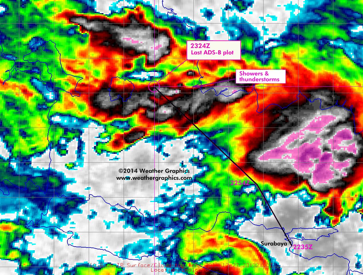
Infrared (10.8 micron) image for 2332 UTC, about 8 minutes after the aircraft disappearance. The image shows conclusively that the aircraft had been flying through deep convective shower and thunderstorm activity prior to the disappearance time. The last ADS-B signal was located about 8 nm northwest of a "cold spot" which is consistent with the signature of mature shower or thunderstorm updraft cores. As this was not a particularly strong cold spot in the storm cluster, it may not have appeared hazardous enough on airborne radar to warrant a deviation.
This shower activity was embedded in a zone of deep easterlies coincident with the intertropical convergence zone (ITCZ). The cells in particular that the aircraft had traversed originated from a multicellular cluster that had developed overnight on the southwest coast of Borneo. The original cells were formed into an east-west line that was dissipating, with a new line of forward flank cell growth and intensification about 30 nm north of the original line between 2332 and 0132 UTC, which is what the aircraft traversed. This cluster then showed dissipation starting with the 0132 UTC image.
Cloud radiance at the aircraft's last location was 201K, which corresponds to a cloud top altitude of 47,000 ft. Coldest cloud tops within 20 nm were 191K (52,000 ft), with the stratified anvil mass for this cluster later measuring 189K (about 53,000 ft). This corresponds fairly well to the sounding parcel lift below and suggests deep, weak instability.

Visible image for 2332 UTC, about 8 minutes after the aircraft disappearance. Numerous shower and thunderstorm tops appear here. Due to the depth of the troposphere in this area, the tops of cumulonimbus and cirrus layers shown here range anywhere from 45,000 to 55,000 ft, and new convective tops are partially obscured by anvils and extensive cirrus debris. The latitude-longitude grid shown here is 1 degree and measures about 60 nm on a side.
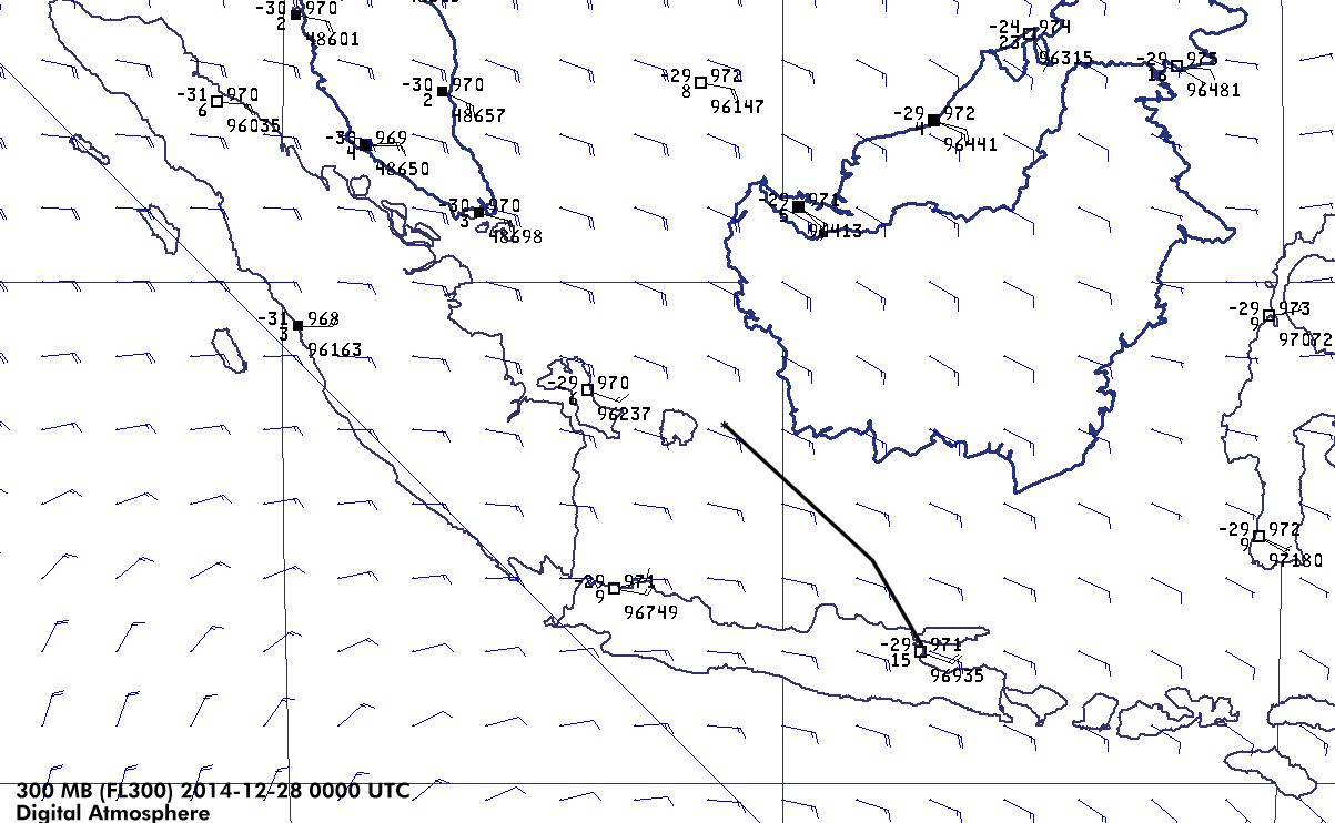
300 mb chart for 0000 UTC as a base reference for flight level conditions. Gridded wind barbs are objectively analyzed estimates from raw data.

Surface chart for 0000 UTC for collecting best representative parcel for sounding data. The onshore flow onto southwest Borneo was likely the original cause of initiation of the cell complex during the previous evening.

Sounding for 0000 UTC, Pangkal-Pinang, about 80 nm west of the aircraft's approximated location. This is a best guess of conditions. Satellite imagery did not suggest convective contamination of the radiosonde launch and this is suggested by the dry conditions in the 1000-800 mb layer. The sounding suggests weak, stratified instability, so the likelihood of turbulence or storm-scale circulations is doubtful. However the strong bulk shear (70 kt) between the lower and upper tropopause was significant and was conducive to long-lived cells, and probably explained the sustained overnight activity in the presence of numerous outflow boundaries across the Java Sea.
Due to the extremely high tropopause (56,000 ft), cloud tops almost certainly extended to above 50,000 ft. The critical icing layer extends from 17,000 to 23,000 ft, with the -20C layer at 27,000 ft. Flight level temperature was -29C. However as evidenced by Air France 447 incident (temperature at flight level -33C), clear icing can occur in much colder temperature regimes given high levels of water loading in the cloud, and the Air France incident raises questions of whether tropical convection is particularly efficient at bringing supercooled water to higher levels.
Conclusion: Based on the available data and a close correlation of thunderstorm activity at the last received location, it appears that weather was a factor, or was a compounding factor. The most likely hazard, if weather was a factor, appears to be icing. This is only an assessment of best available meteorological information, and is not a final determination on the cause of the incident.
© 2014 Tim Vasquez / Weather Graphics
This article may be updated at a later time or date.