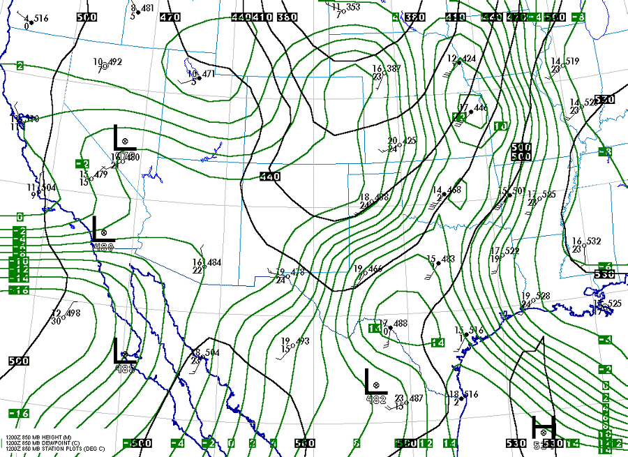
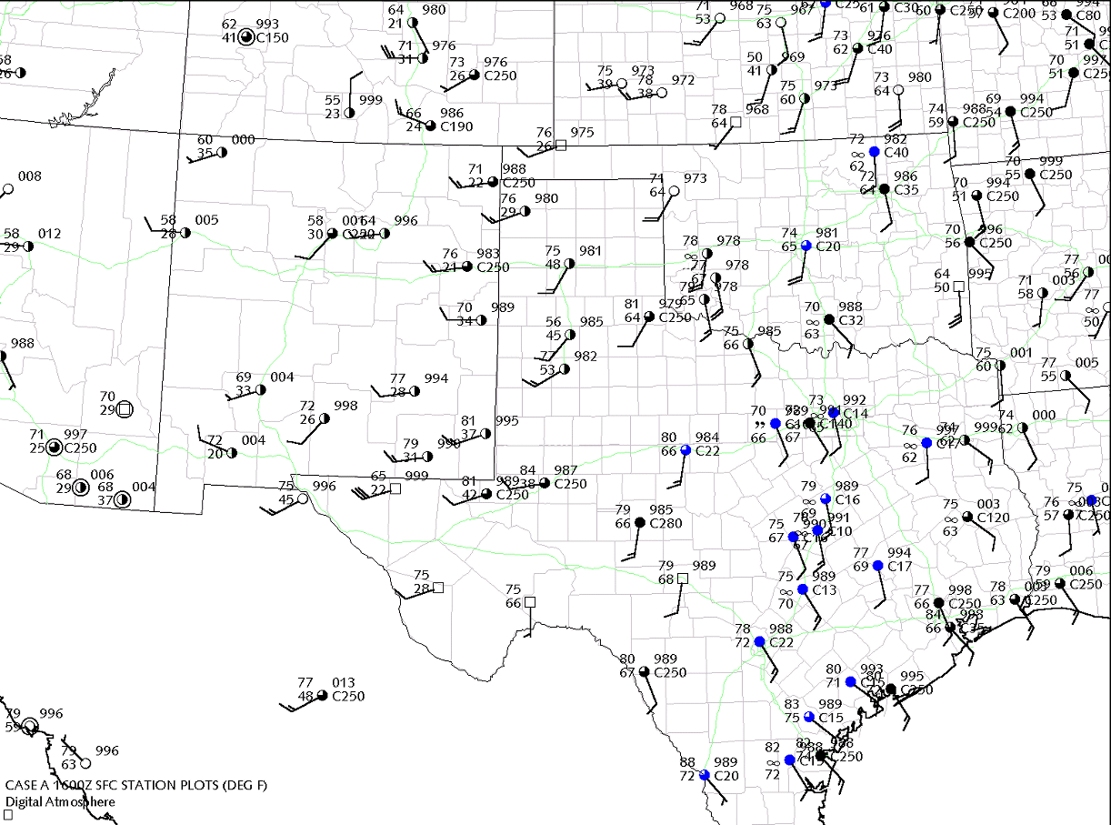
Target Tornadoes occurred in the Cordell-Binger area in west central Oklahoma. 12Z First Glance What follows is a summary of and notes about each chart. This is the general order that I have followed in looking at the patterns (the "top down" approach", then building back out through the soundings). 300 mb chart: What we see is a large trough... in fact one that's right on the doorstep of the Great Plains. Therefore it is going to be a key player in the day's events. We also note strong jet energy riding through the trough from California to Arizona then up to Kansas and Iowa. This strong jet energy confirms that a frontal system is going to be emerging from the Rockies (near the base of the trough). One thing that is unusual about this pattern is that the stronger jet energy is departing the trough (out over Kansas and Nebraska). This means that the Great Plains is in a rear quadrant of the jet, so the right rear quadrant (see map sketch) may couple with lift ahead of the trough axis itself. This may erode the cap over a large area, perhaps lowering the convective temperature a few degrees by afternoon. 500 mb chart: We begin picking up a weak jet axis extending from southern Arizona to Amarillo TX to Omaha NE. This is manifested by the parallel banding of vorticity isopleths coincident with the jet axis (most notable from NE New Mexico to NE Kansas). There is also the suggestion of weak short waves existing through New Mexico and northern Mexico, however the extent of this is not clear due to the limited data resolution (model initializations might pick up on this a bit more). 700 mb chart: Note the weak flow across the Rockies, which hints at a lack of large-scale baroclinicity (fronts, etc). Therefore we shouldn't find any fronts on the surface chart unless we were up in the central Plains at the top of the map. This isn't our area of interest though. However we do note significant crossing of isotherms against the contours throughout the southern Rockies, which indicates baroclinicity and disturbed balance of the geostrophic wind flow. We can expect to find an upper-level disturbance, jet max, or short wave in this area, which would likely lead into our Great Plains area of interest by afternoon. 850 mb chart: What is important here is the EXTENT and DEPTH of the moisture. Here, the dewpoint depressions on the plots have been converted over to dewpoint, shown by the green isopleths. It's important to remember that this is a horizontal SLICE through the atmosphere, at about 5000 ft, and it may not be representative of conditions just below or above it. However we do see a definite moisture axis extending from Del Rio TX to Oklahoma City OK to Kansas City MO. Note how the axis follows the stations reporting the deepest moisture, yet the axis COULD extend just west or east of these stations without violating the data shown. We'll explain this after looking at the surface chart, and will demonstrate proper integration of all the data. Surface 12Z: The 1200Z analysis shows a dryline extending from Hays KS - Canadian TX - Plainview TX - Hobbs NM - Marathon TX. Note the cool, dry conditions west of this dryline, which is a classic example of dry sector air early in the morning. Also note the moist axis, better defined by the low cloud mass, which extends from Austin TX - Abilene TX - Woodward OK. Note how this contrasts with the axis shown on the 850 mb chart, where there is coarser data involved. When considering deep tropical moisture, we usually don't factor in fog (reported here near the southeast corner of New Mexico), since its origins are more related to radiational cooling and ground moisture than to deep tropical moisture. Soundings: A quick summary of the soundings: 16Z Target 16Z surface chart. The dryline now extends from Salina KS - Canadian TX - Big Spring TX - Marathon TX. Note the very strong punch of winds that has developed in the dry sector in the Texas Panhandle. This may be associated with the direct transverse circulation that exists in the rear half of the polar jet. Also note the slight backing of winds at Hobart, OK and Wichita Falls, OK. It would be important for this to continue. 20Z Refinement 20Z surface chart. References ©2003 Tim Vasquez |
