Forecast Center
July/August 2001
by TIM VASQUEZ / www.weathergraphics.com
|
This article is a courtesy copy placed on the author's website for educational purposes as permitted by written agreement with Taylor & Francis. It may not be distributed or reproduced without express written permission of Taylor & Francis. More recent installments of this article may be found at the link which follows. Publisher's Notice: This is a preprint of an article submitted for consideration in Weatherwise ┬® 2001 Copyright Taylor & Francis. Weatherwise magazine is available online at: http://www.informaworld.com/openurl?genre=article&issn=0043-1672&volume=54&issue=4&spage=62. |
PART ONE: The Puzzle
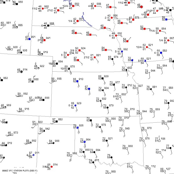
A forecast is literally impossible without a detailed analysis of the current state of the atmosphere. The following puzzle is actual data for a day in April 2001, and youÆll find fronts and important weather features.
Draw isobars every four millibars (992, 996, 1000, 1004, etc) using the plot model example at the lower right as a guide. If we use ōxxxö to represent the plotted pressure, the actual millibar value is 10xx.x mb if xxx is below 500, and if above 500 the value is 9xx.x mb. For instance, ō027ö represents 1002.7 mb and ō892ö represents 989.2 mb. Naturally when a station shows ō073ö and a nearby one shows ō086ö, the 1008 mb isobar will be found halfway between the stations. Locate and sketch in fronts. By convention they are found on the warm side of strong temperature contrasts. There may be other clues, such as a difference in wind direction, wind speed, and observed weather.

Click to enlarge

* * * * *
Scroll down for the solution
* * * * *
PART TWO: The Solution
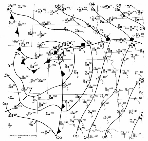
April 6, 2001 was a day where strong upper-level dynamics in the southwestern United States led to rapid pressure falls and development of a vigorous frontal system in the central Plains. By sketching in isobars you will have found an area of deep low pressure in southwest Nebraska.
By looking for a contrast between warm and cool air, you will have found a sharply-defined warm front in Nebraska and Iowa. ItÆs indicated by the line with round semicircles pointed into the cold air mass, showing that warm air is replacing cold air. It divides 70-degree air from frigid, cloudy 40-degree air further north.
You will also have found a cold front, shown here extending from western Kansas into Texas. The sharp barbs point into the warm air mass, showing that cold air is replacing warm air. ThereÆs a weak cold front nosing southward into eastern Colorado. This is a common occurrence when Great Plains cyclones draw colder Canadian air southward through the high Plains region. A pressure trough is shown in New Mexico, indicating an axis of low pressure but no air mass contrast.

Click to enlarge
©2001 Taylor & Francis
All rights reserved