Forecast Center
September/October 2006
by TIM VASQUEZ / www.weathergraphics.com
|
This article is a courtesy copy placed on the author's website for educational purposes as permitted by written agreement with Taylor & Francis. It may not be distributed or reproduced without express written permission of Taylor & Francis. More recent installments of this article may be found at the link which follows. Publisher's Notice: This is a preprint of an article submitted for consideration in Weatherwise © 2006 Copyright Taylor & Francis. Weatherwise magazine is available online at: http://www.informaworld.com/openurl?genre=article&issn=0043-1672&volume=59&issue=5&spage=82. |
PART ONE: The Puzzle
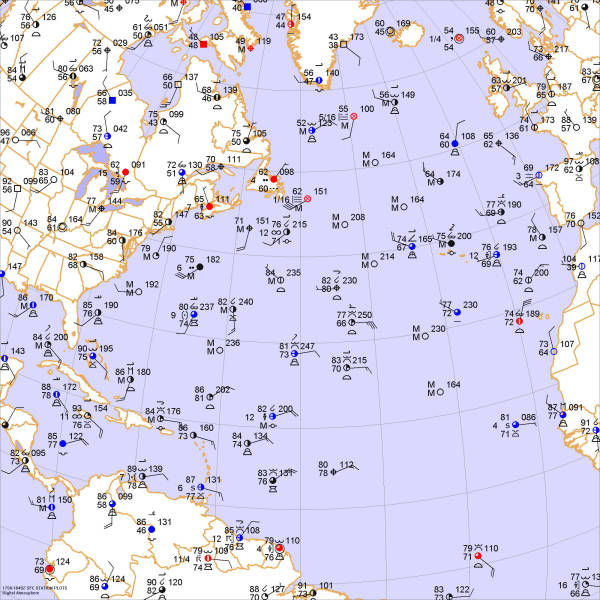
One of the mainstays of summertime weather in the United States is not found on the continent itself, but rather out to sea! Not only does it closely regulate the wind patterns, humidity, and temperatures from Texas to New England, but it also influences the motion of hurricanes and tropical disturbances. To get a closer look, we'll examine the weather data and draw isobars: lines of equal pressure, then identify highs, lows, and fronts.
Draw isobars every eight millibars (1008, 1000, 992, etc.) using the plot model example at the lower right as a guide. As the plot model indicates, the actual millibar value for plotted pressure (xxx) is 10xx.x mb when the number shown is below 500, and 9xx.x when it is more than 500. For instance, 027 represents 1002.7 mb and 892 represents 989.2 mb. Therefore, when one station reports 074 and a nearby one shows 086, the 1008 mb isobar will be found halfway between the stations.

Click to enlarge

* * * * *
Scroll down for the solution
* * * * *
PART TWO: The Solution
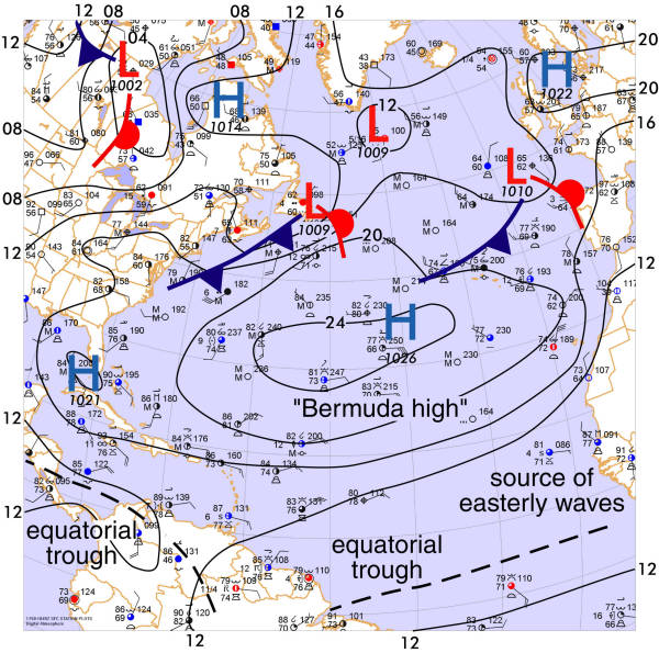
The afternoon of July 24, 2006 was dominated by a subtropical high pressure area centered on the western Atlantic Ocean. The area of closed isobars reached from the Rocky Mountains to near Portugal: a distance of 4000 miles! This feature is not a oddity but is a common sight during the summertime months. It is often referred to as the "Bermuda High", since it stays anchored near the island of Bermuda. A counterpart in the Pacific is typically found north of the Hawaiian Islands.
Subtropical highs develop from two primary influences. One is the relatively cool temperatures over oceanic regions during the summer months. Air over the heated land masses is comparatively less dense, and as a result, barometers show a lower pressure. Furthermore, air flowing northward in the upper troposphere from hot equatorial regions tends to deflect eastward due to the Earth's rotation as it moves poleward. The result is a "pileup" of air around the 20th or 30th parallel, and the accumulated mass of air aloft results in high pressure at the surface. Air sinks to the surface and flows outward to compensate, bringing fair weather to a large region. This is the subtropical high.
The periphery of the subtropical high, however, brings several important weather types. The equatorial regions of the subtropical high contain easterly surface winds known as trade winds. Disturbances known as easterly waves are often embedded in the trade winds. An important source of easterly waves for the Atlantic basin is west Africa. As these waves encounter warm ocean waters, they tend to organize. Given the right atmospheric conditions, as are found in the Caribbean region from July to November, the disturbances may grow into tropical storms or hurricanes. These move westward and then may recurve around the subtropical high towards the United States.
West of the subtropical high, warm, humid tropical air is advected poleward. Since the Bermuda high is such a permanent fixture, this gives the eastern United States its characteristically hot, monotonous weather. North of the subtropical high, the prevailing westerlies are active but in a much smaller belt that largely remains in Canada and the northern tier states. These westerlies contain extratropical storm systems which are much weaker than those that occur during the winter months. In this issue, two such systems are in the process of crossing the Atlantic from Newfoundland to France.
As winter arrives and ocean waters become relatively warm, the subtropical high weakens and shifts equatorward. It is periodically reinforced by stagnating polar air masses which reach the tropics. The temperate latitudes become stormy and American forecasters turn their attention to the west and north.

Click to enlarge
©2006 Taylor & Francis
All rights reserved