Forecast Center
November/December 2006
by TIM VASQUEZ / www.weathergraphics.com
|
This article is a courtesy copy placed on the author's website for educational purposes as permitted by written agreement with Taylor & Francis. It may not be distributed or reproduced without express written permission of Taylor & Francis. More recent installments of this article may be found at the link which follows. Publisher's Notice: This is a preprint of an article submitted for consideration in Weatherwise © 2006 Copyright Taylor & Francis. Weatherwise magazine is available online at: http://www.informaworld.com/openurl?genre=article&issn=0043-1672&volume=59&issue=6&spage=74. |
PART ONE: The Puzzle
Anyone who's done a little forecasting is well-versed with the cold front and the warm front. The reputation of cold fronts are built largely on showers and rapid change, while warm fronts are associated with foggy, dreary conditions that improve with a warming trend. However, a relatively unknown feature is the occluded front. It's a familiar friend to weather enthusiasts in the Great Lakes and Canada, but in other regions it is a rare visitor. In this puzzle we'll learn how to spot occluded fronts and review the different types of weather that occlusions bring.
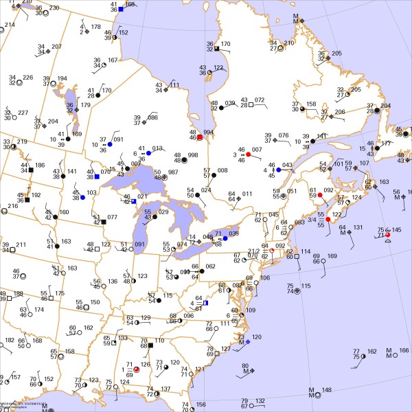
This weather map is for a September evening at midnight. Draw isobars every eight millibars (1008, 1000, 992, etc.) using the plot model example at the lower right as a guide. As the plot model indicates, the actual millibar value for plotted pressure (xxx) is 10xx.x mb when the number shown is below 500, and 9xx.x when it is more than 500. For instance, 027 represents 1002.7 mb and 892 represents 989.2 mb. Therefore, when one station reports 074 and a nearby one shows 086, the 1008 mb isobar will be found halfway between the stations.

Click to enlarge

* * * * *
Scroll down for the solution
* * * * *
PART TWO: The Solution
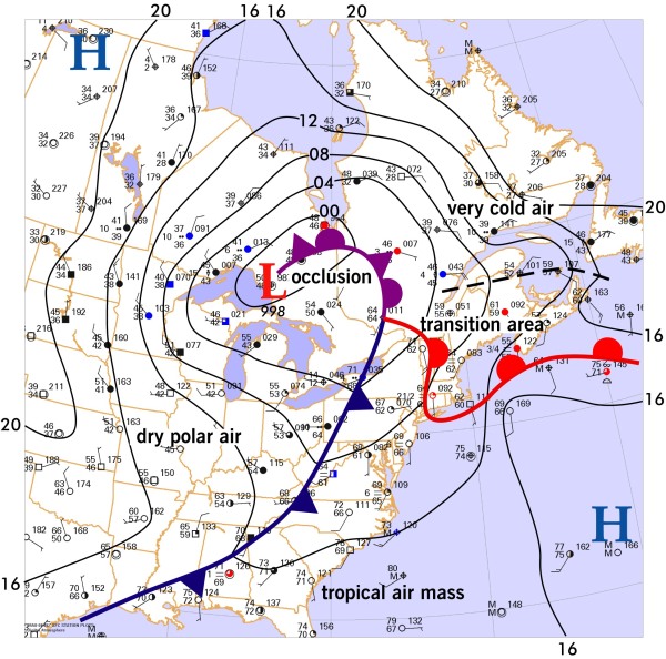
The midnight hours of September 18-19, 2006 showed a cold front moving through the eastern United States, with a cold air mass sweeping into the Great Lakes region and Ohio River Valley. Though wind fields were very weak along the tail end of the front, isobaric analysis clearly showed the associated pressure trough, which extended through the Appalachian regions into Georgia. A tropical air mass covered much of the Atlantic seaboard, reaching all the way into New York.
A third air mass was present in Maine, Nova Scotia, and New Brunswick, where fog, low clouds, and cool temperatures lingered. This was separated from the tropical air mass by a warm front that crossed through New England. The warm front and the cold front joined together in far southern Quebec.
Some readers might find it astonishing that the surface low is not found at this junction but rather quite a distance away near Lake Superior. It's certainly surprising since weather maps quite often show surface lows at the spot where warm fronts and cold fronts connect. So, then, why is the surface low 500 miles away?
When frontal systems are in their developing phases, the surface low is always along the frontal boundary. But as air masses spiral together around the low, the cold front quite often "catches up" with the warm front, forcing one of the air masses aloft. This creates a new front at the surface called an occluded front. The junction of all three air masses, in other words where the occluded front meets the cold front and warm front, is known as the triple point. As more and more occlusion takes place, the triple point shifts farther and farther away. The low pressure area becomes what is known as a cold-core low, then slowly begins filling as the two air masses along the occluded front wrap around each other and homogenize. Occluded systems are always in a process of decay. New cyclogenesis may occur at the triple point, thus on this issue's puzzle, the hot spot for new development is in the Montreal area.
Occlusions may take one of two forms. If a very dense cold air mass catches up to a less dense cold air mass, it behaves like a cold front and is called a cold occlusion. The deepest warm air aloft is found just behind the surface front. This is the most common type of occlusion in North America and is depicted in this issue's puzzle. If a less dense cold air mass catches up to a very dense cold air mass, the result is called a warm occlusion. The characteristics of such an occlusion are much like that of a warm front, and the deepest warm air aloft is aligned ahead of the surface front. Warm occlusions are typically only seen in the polar North Pacific region and off the Norwegian coast.
The basic weather pattern along occluded fronts depends on which type of occlusion is present, as described above. With sufficient instability, embedded showers and thunderstorms can develop in the deepest warm air aloft and sometimes within the cold-core low itself. However these weather patterns usually improve as the system decays, and attention soon refocuses on the triple point, where new development takes place.

Click to enlarge
©2006 Taylor & Francis
All rights reserved