Forecast Center
September/October 2007
by TIM VASQUEZ / www.weathergraphics.com
|
This article is a courtesy copy placed on the author's website for educational purposes as permitted by written agreement with Taylor & Francis. It may not be distributed or reproduced without express written permission of Taylor & Francis. More recent installments of this article may be found at the link which follows. Publisher's Notice: This is a preprint of an article submitted for consideration in Weatherwise © 2007 Copyright Taylor & Francis. Weatherwise magazine is available online at: http://www.informaworld.com/openurl?genre=article&issn=0043-1672&volume=60&issue=5&spage=82. |
PART ONE: The Puzzle
During the summer months, the polar front jet retreats northward into Canada. The United States comes under the influence of subtropical high pressure, and storm tracks begin following a path that extends from the Canadian Prairie provinces eastward to Ontario and Quebec. In this puzzle we'll take a rare excursion from United States weather and examine a random summer day in these northern areas.
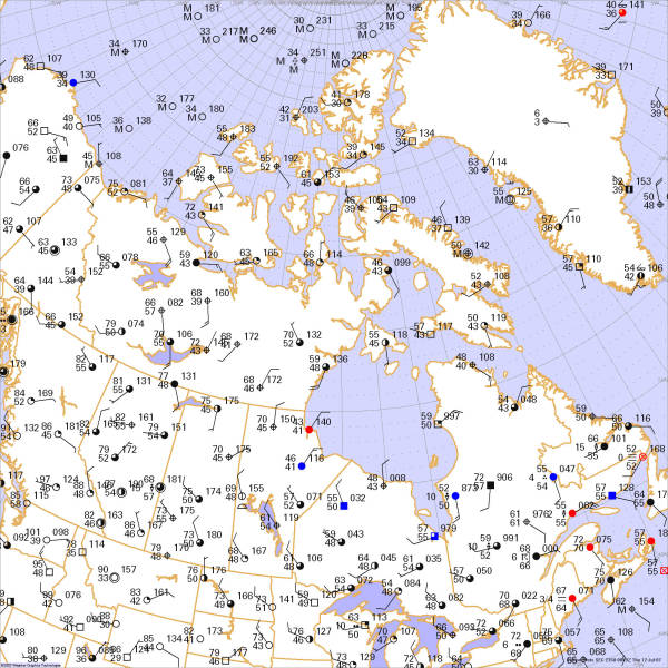
This weather map is for the afternoon hours in July. Draw isobars every four millibars (1008, 1004, 1000, 996, etc.) using the plot model example at the lower right as a guide. As the plot model indicates, the actual millibar value for plotted pressure (xxx) is 10xx.x mb when the number shown is below 500, and 9xx.x when it is more than 500. For instance, 027 represents 1002.7 mb and 892 represents 989.2 mb. Therefore, when one station reports 074 and a nearby one shows 086, the 1008 mb isobar will be found halfway between the stations. Then try to find the locations of fronts, highs, and lows.

Click to enlarge

* * * * *
Scroll down for the solution
* * * * *
PART TWO: The Solution
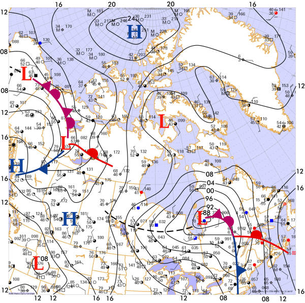
July 11, 2007 brought a heat wave to much of southwestern Canada, especially across British Columbia. The town of Chilliwack saw temperatures climb to 102°F, and the coastal city of Victoria reached 97°F. The utility company BC Hydro, suffering from an overloaded infrastructure, began asking commercial users in Vancouver's main business district to conserve energy.
Unfortunately, cool relief from the Pacific Ocean was bypassing this area and heading into northern British Columbia and Yukon, riding underneath southwesterly upper-level flow. In this area, mild temperatures and southwesterly winds signalled the arrival of a cold front, but it would make little eastward progress.
Further northward, large-scale high pressure covered much of the Arctic Ocean ice pack and Greenland. In the winter, the coldest temperatures are found in the continental regions of northern North America and Asia, but during the summer as land masses heat up, the "cold pole" moves to the polar ice pack. High pressure dominates this area, and as a result wind directions along the Arctic Ocean coast are often northerly or northeasterly during the warm season.
In southeast Canada, the polar front jet was active and a powerful weather system was on the march. This frontal system was no different from those which usually affect the United States during the transition seasons. Environment Canada issued severe thunderstorm warnings for eastern Ontario and western Quebec early in the afternoon, predicting rain accompanied by powerful winds, large hail and intense lightning. Lightning strikes in the Ottawa area sent seven people to hospitals.
Finally, a weak low can be found in northern Hudson Bay. This area, especially eastward towards Greenland, is a "dumping ground" for weather systems that have moved across eastern North America and occluded, especially during the winter months. Numerous surface lows may be found in this region, slowly filling until they are no longer found on surface charts. The lack of dense surface data makes them hard to predict, and they are often the source of sudden, unforeseen weather changes.
Computer programs do not produce the Forecast Center solutions. All fronts and isobars are drawn by hand using illustration software.

Click to enlarge
©2007 Taylor & Francis
All rights reserved