Forecast Center
November/December 2010
by TIM VASQUEZ / www.weathergraphics.com
|
This article is a courtesy copy placed on the author's website for educational purposes as permitted by written agreement with Taylor & Francis. It may not be distributed or reproduced without express written permission of Taylor & Francis. More recent installments of this article may be found at the link which follows. Publisher's Notice: This is a preprint of an article submitted for consideration in Weatherwise © 2010 Copyright Taylor & Francis. Weatherwise magazine is available online at: http://www.informaworld.com/openurl?genre=article&issn=0043-1672&volume=63&issue=6&spage=68. |
PART ONE: The Puzzle
For those of us in the United States, the transition to fall conjures images of autumn leaves, windy days, and brisk evenings, much of this caused by the arrival of cold Canadian air. But what happens elsewhere in the northern hemisphere? Do the cold outbreaks come from the north pole, Siberia, or elsewhere? In this puzzle we'll take a look at fall patterns in Europe and western Asia.
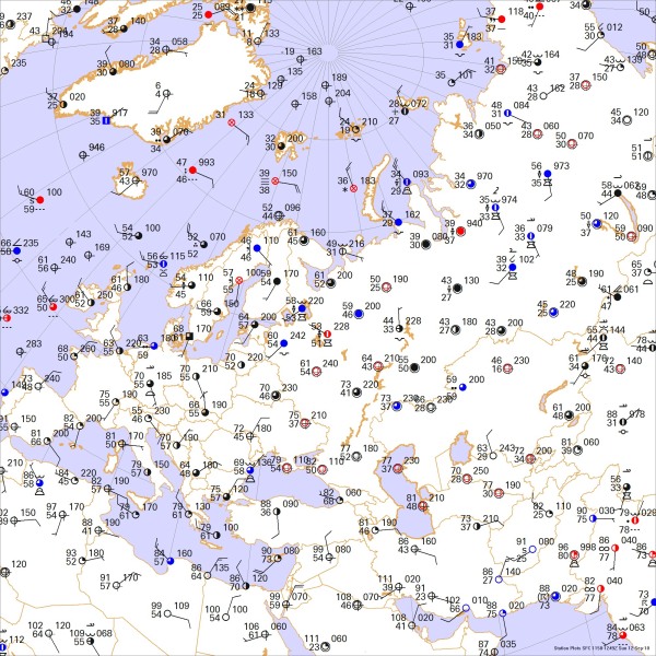
This weather map depicts a daytime situation in September. Draw isobars every four millibars (996, 1000, 1004 mb, etc) using the plot model example at the lower right as a guide. As the plot model indicates, the actual millibar value for plotted pressure (xxx) is 10xx.x mb when the number shown is below 500, and 9xx.x when it is more than 500. For instance, 027 represents 1002.7 mb and 892 represents 989.2 mb. Therefore, when one station reports 074 and a nearby one shows 086, the 1008 mb isobar will be found halfway between the stations. Then try to find the locations of fronts, highs, and lows.

Click to enlarge

* * * * *
Scroll down for the solution
* * * * *
PART TWO: The Solution
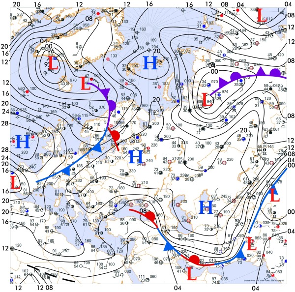
The afternoon of September 12, 2010 showed a broad high pressure area covering much of western Russia. This is indeed a cold air mass caused by a combination of gradual expansion of cold air in the polar regions, new areas of snow cover in far northern Siberia, and pronounced nighttime radiational cooling. In the northern latitudes, September brings five new minutes of darkness each night, translating to even more lost thermal energy.
The cold air mass on this date was large enough to cover all of the former Soviet states, with a very strong pressure gradient in the Middle East where isobars packed close together. In the Persian Gulf region, the solar heating is still quite strong, as shown by the 100-degree temperatures. This causes tremendous erosion of the edges of the cold air mass, which is already dammed by the mountainous terrain of Pakistan, Iran, and Turkey. As a result, the cold front stalls and becomes a stationary front. If the upper-level patterns and cold air depth is favorable, the cold air can invade Iraq, Saudi Arabia, and the Persian Gulf area, though this tends to happen mostly later in the fall.
But the stalled front is not insignificant. Where it impinges on humid tropical air, as shown in Pakistan and India where dewpoints show a sultry 75 degrees, the front and the convergence zone that accompanies it can serve as a potent source of lift. Showers and thunderstorms are the result. This is an unfortunate pattern, as Pakistan had already been deluged with torrential rains during the previous few weeks, causing thousands of deaths and extensive agricultural damage.
The map shows strong northerly winds in Africa, especially in Egypt and Libya. This is partly due to the influence of stagnant European air masses, the relatively cool temperatures of the Mediterranean Sea, and strong heating in the Sahara Desert region. Here a thermal trough can be detected at the lower left corner of the map. Thermal troughs, which are discussed in the last issue's installment of Forecast Center, are caused by low barometric pressure that coincides with strong solar heating, and can be associated with rain if there is a source of moisture.
Further north, a strong weather system from the Atlantic Ocean moves eastward into Scandinavia and the Baltic region, with a cold high pressure region south of Ireland. The 70-degree temperatures found in eastern Europe will soon be replaced with the 60s found in France and England as the front moves eastward. Note how the cold front transitions to an occluded front over Norway. This is because significant temperature contrasts are found across the front in Germany and France, but not in Scandinavia. The "warm sector" with its 70-degree temperatures is found only in the southern Baltic Sea region, and by definition the cold front and warm front are found along the warm sector's margins.
A very strong weather system is found in northern Siberia, centered on the Russian mining city of Norilsk. Though a front can be found in the pressure trough extending southward, there is no evidence of a true "warm sector". All of the air in Siberia is part of a cold air mass. So without a warm sector, an occluded front is suggested. The low near Norilsk is a decaying wave, once an active frontal system in southern Russia which occluded and moved northward. Its destiny is to weaken and dissipate along the northern coast of Siberia, a favored graveyard for old cyclones much like that near Baffin Island in North America.
Computers do not produce the puzzle solution. The weather chart is created automatically with Digital Atmosphere, but fronts and isobars are added by hand using Adobe Illustrator.

Click to enlarge
©2010 Taylor & Francis
All rights reserved