Search found 26 matches
- Fri Aug 11, 2006 9:34 pm
- Forum: Digital Atmosphere
- Topic: DA WS Satellite images/Tropical Plots
- Replies: 45
- Views: 61316
City Zoom Satellite Images
After playing with DAWS for some time, I was able to create a map with the New Orleans, Louisiana Satellite Zoom from NRL: Latitude: 29.953 Longitude: -90.250 Scale: 134 Width x Height: 800 x 800 Projection: Orthographic Image Path: http://www.nrlmry.navy.mil/focus_public/CONUS/focus_regions/City_Zo...
- Sun Dec 18, 2005 9:57 pm
- Forum: The Lounge
- Topic: Neat DAWS Map from Hurricane Katrina
- Replies: 12
- Views: 46318
joint operations graphic raster maps
The most detailed according to the generate map menu is joint operations graphic raster map (1:250K). The program will not allow me to make one of these and I was wondering how detailed it got. The most detailed I can get is Tactical Pilotage Chart (1:500K).
- Sun Dec 18, 2005 9:47 pm
- Forum: The Lounge
- Topic: Neat DAWS Map from Hurricane Katrina
- Replies: 12
- Views: 46318
Re:
Thanks! I used the New Orleans Radar and station plots.
Would you happen to have an image sample of the most detailed kind of map that comes with DAWS Pro?
If you cannot post it, you can email it to me at weatherguy08@hotmail.com.
weatherguy08
http://www.freewebs.com/jays_weather_center
Would you happen to have an image sample of the most detailed kind of map that comes with DAWS Pro?
If you cannot post it, you can email it to me at weatherguy08@hotmail.com.
weatherguy08
http://www.freewebs.com/jays_weather_center
- Sun Dec 18, 2005 7:51 pm
- Forum: The Lounge
- Topic: Neat DAWS Map from Hurricane Katrina
- Replies: 12
- Views: 46318
See topic Ooops
I made two mistakes. First I didn't make the image post right then I accidently posted a new topic. I am having a bad day!

weatherguy08
weatherguy08
- Sun Dec 18, 2005 7:50 pm
- Forum: The Lounge
- Topic: Ooops!
- Replies: 0
- Views: 13439
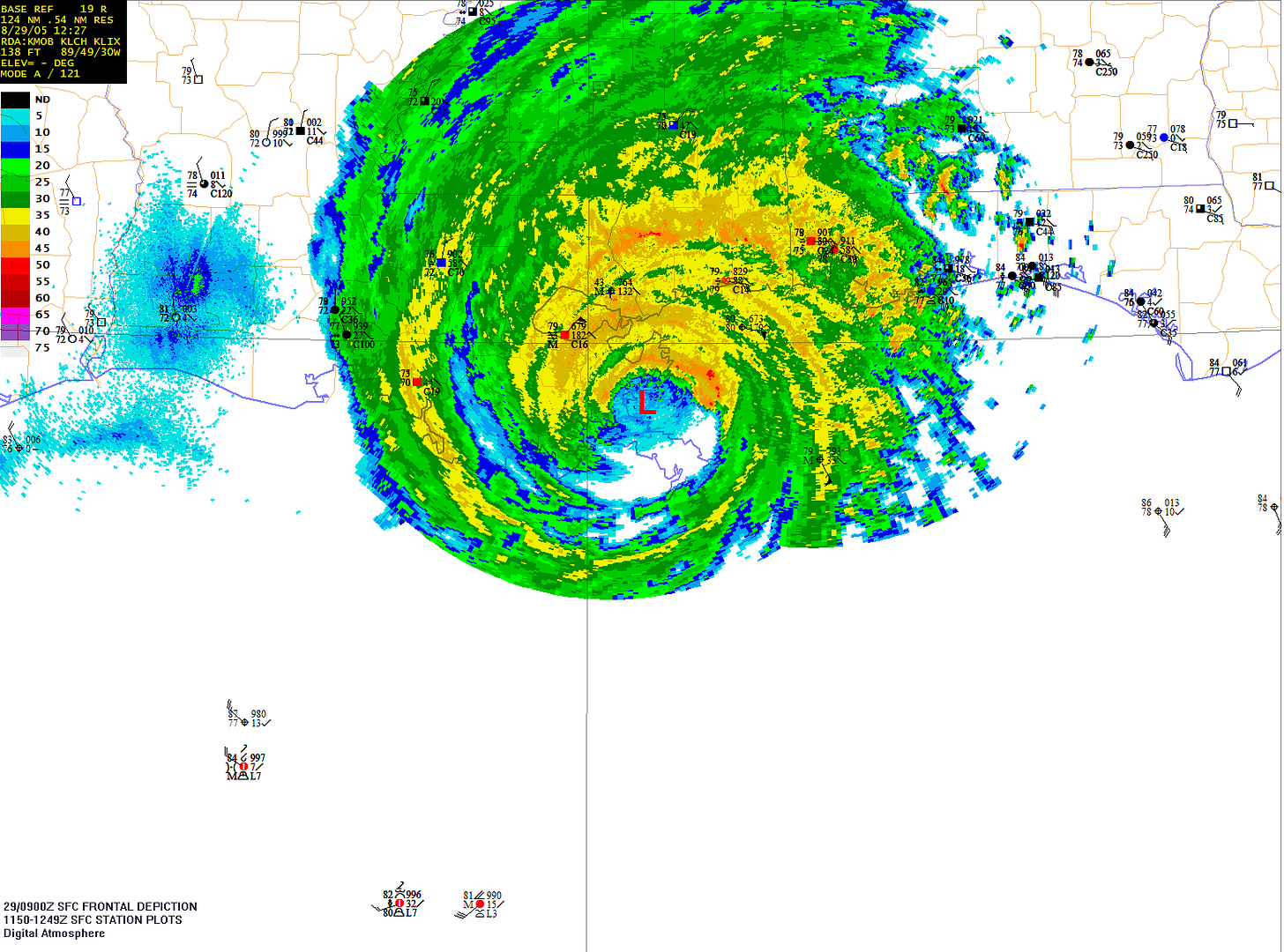
Ooops!
Since the map did not post right, you can just highlight the URL and paste in the address bar to see it.
Sorry
http://i11.photobucket.com/albums/a200/ ... of8-29.png
Sorry
http://i11.photobucket.com/albums/a200/ ... of8-29.png
- Sun Dec 18, 2005 7:49 pm
- Forum: The Lounge
- Topic: Neat DAWS Map from Hurricane Katrina
- Replies: 12
- Views: 46318
Neat DAWS Map from Hurricane Katrina
I thought I would post some way cool maps I made using DAWS for Hurricane Katrina. I am in Louisiana but the worst damage we got was a fence blew down during Rita (I was about 70 miles to the right of the eye). No damage at all during Katrina (I was about 100 miles to the left of the eye). http://i1...
- Sun Dec 18, 2005 1:51 am
- Forum: Digital Atmosphere
- Topic: Questions about Pro Version
- Replies: 6
- Views: 10139
- Sun Dec 18, 2005 1:35 am
- Forum: Digital Atmosphere
- Topic: Questions about Pro Version
- Replies: 6
- Views: 10139
joint operations graphic raster maps
About how detailed do these maps get? Will I be able to see specific streets? What exactly is on them?
- Sun Dec 18, 2005 12:45 am
- Forum: Digital Atmosphere
- Topic: Questions about Pro Version
- Replies: 6
- Views: 10139
More about topo maps
I have the regular DAWS and I went to NYC to view them. Is what is available on here as far as you can zoom in on professional? Can you get down to street-level say for a small town (>100,000 people)?
weatherguy08
weatherguy08
- Fri Dec 16, 2005 4:14 am
- Forum: Digital Atmosphere
- Topic: Questions about Pro Version
- Replies: 6
- Views: 10139
Questions about Pro Version
When the ad says "topographic maps" does this mean it will become your regular background map once you zoom in to a certain point? How detailed are the maps and what is on them (streets, water bodies, airports, ect). I have this on my Christmas List and I just want to verify some of the fa...