I apologize, I can tell I'm really confusing you. Not your fault at all, it's mine. For the PROJECT, I have to plot 11/12/2003 (I don't have 11/12 though). If you can help me w/ 11/05/2002 4:00 PM EST, I can then compare THOSE results with the sample that I have. And no, I don't have any raw data files. I just retrieved the data from online using DA. Do you follow me, now?weasel2 wrote:If you want, I'll do up some maps in Digital Atmosphere from 11/12/2003 and send them your way (it would help if I knew the exact hour used). Maybe they will match you teacher's fairly close - and if they do, you should feel somewhat confident in using Digital atmosphere for your project.
Edit: Do you have the raw data file from 11/12/2003?
Isobars in Digital Atmosphere
-
footballrunner11
- Member
- Posts: 18
- Joined: Sat Dec 08, 2007 10:53 pm
I'll see if I can find the disk for 11/05/2002footballrunner11 wrote:I apologize, I can tell I'm really confusing you. Not your fault at all, it's mine. For the PROJECT, I have to plot 11/12/2003 (I don't have 11/12 though). If you can help me w/ 11/05/2002 4:00 PM EST, I can then compare THOSE results with the sample that I have. And no, I don't have any raw data files. I just retrieved the data from online using DA. Do you follow me, now?
Is the chart for the whole US?
-
footballrunner11
- Member
- Posts: 18
- Joined: Sat Dec 08, 2007 10:53 pm
-
footballrunner11
- Member
- Posts: 18
- Joined: Sat Dec 08, 2007 10:53 pm
WOW! Very, very close. The isobars snake a bit more on the sample, but for the most part, they are identical. However, my map includes ALL of Texas and even a portion of New Mexico. Is there anyway you could generate a map for 11-12-2003, perhaps with station plots included?
Thank you very much, this really is nice of you to do. I appreciate all of the help thus far!
Thank you very much, this really is nice of you to do. I appreciate all of the help thus far!
footballrunner11 wrote:WOW! Very, very close. The isobars snake a bit more on the sample, but for the most part, they are identical. However, my map includes ALL of Texas and even a portion of New Mexico. Is there anyway you could generate a map for 11-12-2003, perhaps with station plots included?
Thank you very much, this really is nice of you to do. I appreciate all of the help thus far!
What hour would you like for 11/12/2003?
Glad it looks close
Pat
-
footballrunner11
- Member
- Posts: 18
- Joined: Sat Dec 08, 2007 10:53 pm
As long as it's close, I should be able to do it on my own anyway. I just need a close guideline to help me out. Anyway, the hour on 11/12/03 is 3:00 PM.weasel2 wrote:What hour would you like for 11/12/2003?
Glad it looks close
Pat
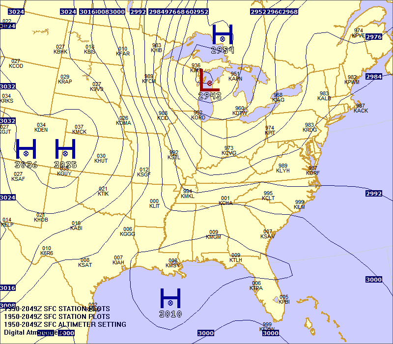
Also remember, if possible, could you try including at least some station plots so I have a general idea of where to draw the isobars. The stations are 3 letter acronyms in the stuff my teacher gave me.
Just remove the K from the station Identifiers. The Altimeter Setting is in the upper right of the plot.footballrunner11 wrote:As long as it's close, I should be able to do it on my own anyway. I just need a close guideline to help me out. Anyway, the hour on 11/12/03 is 3:00 PM.
Also remember, if possible, could you try including at least some station plots so I have a general idea of where to draw the isobars. The stations are 3 letter acronyms in the stuff my teacher gave me.

-
footballrunner11
- Member
- Posts: 18
- Joined: Sat Dec 08, 2007 10:53 pm
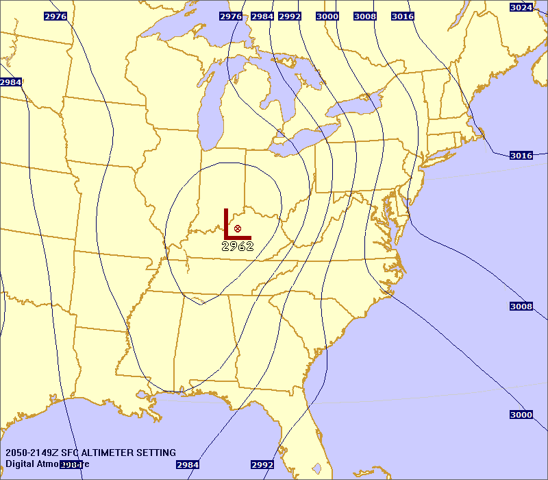
Hrmmm... This is for November 12, 2003 at 3 PM? I remember looking at a friend's map that had already finished their project and I remember there being a short isobar crossing Florida... strange how the other was so accurate and this one, not so much. Hmmm... any ideas?weasel2 wrote:Just remove the K from the station Identifiers. The Altimeter Setting is in the upper right of the plot.
Regardless, thanks a bunch. I'll still probably base my isobars on the above image and then ask my teacher if it looks correct, Monday in school.
I did "smooth" the isobars a little to make them look better, so this may have caused the difference. I'll do one that isn't as smooth. I also only included the station ID and Altimeter settingfootballrunner11 wrote:Hrmmm... This is for November 12, 2003 at 3 PM? I remember looking at a friend's map that had already finished their project and I remember there being a short isobar crossing Florida... strange how the other was so accurate and this one, not so much. Hmmm... any ideas?
Regardless, thanks a bunch. I'll still probably base my isobars on the above image and then ask my teacher if it looks correct, Monday in school.