Hi,
Is it possible to create a CAPE script.
Ian
Cape Script
Me again,
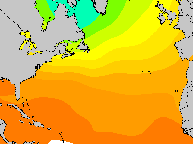
all so i am doing a sst script
see below,
#SST
ingest,C:\Program Files\DigitalAtmosphereWS\data\syn*.dat
ANALYZE,CONT EQUA=5 COLOR=71:60:139 CONT EQUA=6 COLOR=72:118:255 CONT EQUA=6 COLOR=67:110:238 CONT EQUA=8 COLOR=238:238:0 CONT EQUA=10 COLOR=255:215:0 CONT EQUA=12 COLOR=255:193:37 CONT EQUA=14 COLOR=255:000:000 CONT EQUA=16 COLOR=238:64:0 CONT EQUA=18 COLOR=205:55:0 CONT EQUA=20 COLOR=139:37:0 CONT EQUA=22 COLOR=000:000:000 TSEA
import,C:\Program Files\DigitalAtmosphereWS\overlay.gif
STAMP
export,C:\website's\data\charts\SST.gif
but i would like the contores NOT to go over the counties.
Like so

Any ideas
all so i am doing a sst script
see below,
#SST
ingest,C:\Program Files\DigitalAtmosphereWS\data\syn*.dat
ANALYZE,CONT EQUA=5 COLOR=71:60:139 CONT EQUA=6 COLOR=72:118:255 CONT EQUA=6 COLOR=67:110:238 CONT EQUA=8 COLOR=238:238:0 CONT EQUA=10 COLOR=255:215:0 CONT EQUA=12 COLOR=255:193:37 CONT EQUA=14 COLOR=255:000:000 CONT EQUA=16 COLOR=238:64:0 CONT EQUA=18 COLOR=205:55:0 CONT EQUA=20 COLOR=139:37:0 CONT EQUA=22 COLOR=000:000:000 TSEA
import,C:\Program Files\DigitalAtmosphereWS\overlay.gif
STAMP
export,C:\website's\data\charts\SST.gif
but i would like the contores NOT to go over the counties.
Like so
Any ideas
For Cape values you`ll need grib, but unfortunately daws does not support scripting with grib data.
As for the sst, I don`t that`s possible to avoid contouring over the land without importing complicated overlays etc.
Ie: You could create two basemaps. One for daws, and second would be edited on photoshop or something. Make the sea areas transparent, and the landmass solid. Then just import the edited basemap as a png image at the end of your script. It might work.
HI MATE,
#SST
ingest,C:\Program Files\DigitalAtmosphereWS\data\syn*.dat
ANALYZE,CONT EQUA=5 OVER FILL COLOR=71:60:139 CONT EQUA=6 OVER FILL COLOR=72:118:255 CONT EQUA=6 OVER FILL COLOR=67:110:238 CONT EQUA=8 OVER FILL COLOR=238:238:0 CONT EQUA=10 OVER FILL COLOR=255:215:0 CONT EQUA=12 OVER FILL COLOR=255:193:37 CONT EQUA=14 OVER FILL COLOR=255:000:000 CONT EQUA=16 OVER FILL COLOR=238:64:0 CONT EQUA=18 OVER FILL COLOR=205:55:0 CONT EQUA=20 OVER FILL COLOR=139:37:0 CONT EQUA=22 OVER FILL COLOR=000:000:000 TSEA
import,C:\Program Files\DigitalAtmosphereWS\overlay_uksst.gif
STAMP