SST colourfill
SST colourfill
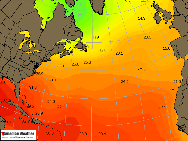
Following on from Ian`s thread about sst`s, I thought I`d put something together using colourfill scripting. Came out pretty good....
I don`t know, but I have feeling I might be growing banana trees in Atlantic Canada this winter!!! Gotta love climate change  I can just hear the cries of despair from local ski operators, for a third year running!
Ps. Pat, you had problem generating mercator maps in Fusion? I keep getting I/O errors.
Ps. Pat, you had problem generating mercator maps in Fusion? I keep getting I/O errors.
I don't think I've generated a mercator in Fusion except for once. Chris mentioned mercators saved in DA WS weren't importing/displaying without an error in Fusion quite some time ago. I'm pretty sure I posted a way to get around that problem... not unless something changed between now and then?
Pat
Nice looking SST BTW
Edit: just did a mercator using the US preset and no error popped up? Odd..
Pat
Nice looking SST BTW
Edit: just did a mercator using the US preset and no error popped up? Odd..
-
severe storm_forecaster
- Member
- Posts: 51
- Joined: Wed Mar 08, 2006 3:42 am
- Location: In a tent in no mans land!
- Contact:
Re: sst's
Very nice Bob. Do you have the script for this?
I could use this for my tropical page.
Randy
I could use this for my tropical page.
Randy
Sorry about that, yes here you go....
Remember for the imported map, you`ll need to use photoshop or something and make the sea background transparent.
Of course with the imported overlay you can add whatever you like, logos, colour gradient legends etc using photoshop.
Remember for the imported map, you`ll need to use photoshop or something and make the sea background transparent.
If you`re using a custom logo via the preferences option, you`ll need to switch the import line before the data plots else your imported map will overlay the logo. Hopefully Tim can improve on the logo/annotations settings.analyze,OVER FILL COLOR=0:20:255 GRTN=0 TSEA
analyze,OVER FILL COLOR=0:43:255 GRTN=1
analyze,OVER FILL COLOR=0:89:255 GRTN=2
analyze,OVER FILL COLOR=0:115:255 GRTN=3
analyze,OVER FILL COLOR=0:140:255 GRTN=4
analyze,OVER FILL COLOR=0:166:255 GRTN=5
analyze,OVER FILL COLOR=0:191:255 GRTN=6
analyze,OVER FILL COLOR=0:222:255 GRTN=7
analyze,OVER FILL COLOR=0:255:255 GRTN=8
analyze,OVER FILL COLOR=0:243:230 GRTN=9
analyze,OVER FILL COLOR=0:230:204 GRTN=10
analyze,OVER FILL COLOR=0:217:166 GRTN=11
analyze,OVER FILL COLOR=0:222:141 GRTN=12
analyze,OVER FILL COLOR=0:204:127 GRTN=13
analyze,OVER FILL COLOR=0:191:63 GRTN=14
analyze,OVER FILL COLOR=0:179:0 GRTN=15
analyze,OVER FILL COLOR=63:191:0 GRTN=16
analyze,OVER FILL COLOR=127:204:0 GRTN=17
analyze,OVER FILL COLOR=166:217:0 GRTN=18
analyze,OVER FILL COLOR=204:230:0 GRTN=19
analyze,OVER FILL COLOR=230:243:0 GRTN=20
analyze,OVER FILL COLOR=255:255:0 GRTN=21
analyze,OVER FILL COLOR=255:230:0 GRTN=22
analyze,OVER FILL COLOR=255:222:1 GRTN=23
analyze,OVER FILL COLOR=255:204:0 GRTN=24
analyze,OVER FILL COLOR=255:179:0 GRTN=25
analyze,OVER FILL COLOR=255:153:0 GRTN=26
analyze,OVER FILL COLOR=255:127:0 GRTN=27
analyze,OVER FILL COLOR=255:102:0 GRTN=28
analyze,OVER FILL COLOR=255:51:0 GRTN=29
analyze,OVER FILL COLOR=255:0:0 GRTN=30
analyze,OVER FILL COLOR=230:0:0 GRTN=31
analyze,OVER FILL COLOR=204:0:0 GRTN=32
analyze,OVER FILL COLOR=179:0:0 GRTN=33
analyze,OVER FILL COLOR=153:0:0 GRTN=34
SFCPLOTMODEL,C:\Documents and Settings\Bob\My Documents\daws\sst.sps
product,PLF,0,Surface Plots
import,C:\Documents and Settings\Bob\My Documents\daws\overlays\northatlantic.png
stamp
export,C:\Documents and Settings\Bob\My Documents\daws\products\sstatlantic.png
Of course with the imported overlay you can add whatever you like, logos, colour gradient legends etc using photoshop.
-
severe storm_forecaster
- Member
- Posts: 51
- Joined: Wed Mar 08, 2006 3:42 am
- Location: In a tent in no mans land!
- Contact:
Re: maps
Hi Bob:
I need you to do me two favors, if you can. First I was wondering if you could design me a custom logo for my charts. Second, since I don't have photoshop, could you create a couple basemaps with the sea area transparent for me? You can then contact me offlist for more details and such.
Thanks,
Randy
-
severe storm_forecaster
- Member
- Posts: 51
- Joined: Wed Mar 08, 2006 3:42 am
- Location: In a tent in no mans land!
- Contact:
Re: maps
" wrote:Hi Bob:
I need you to do me two favors, if you can. First I was wondering if you could design me a custom logo for my charts. Second, since I don't have photoshop, could you create a couple basemaps with the sea area transparent for me? You can then contact me offlist for more details and such.
My email: forecaster@charter.net Sorry about this!
Thanks,
Randy