SST colourfill
Posted: Thu Oct 05, 2006 8:11 pm
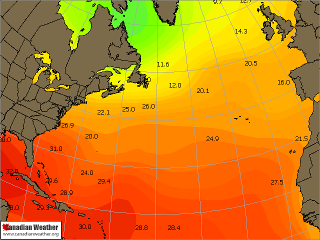
Following on from Ian`s thread about sst`s, I thought I`d put something together using colourfill scripting. Came out pretty good....
Discussions about the latest in meteorology, programs, tools, and techniques
https://www.weathergraphics.com/forum/
https://www.weathergraphics.com/forum/viewtopic.php?f=9&t=1066
If you`re using a custom logo via the preferences option, you`ll need to switch the import line before the data plots else your imported map will overlay the logo. Hopefully Tim can improve on the logo/annotations settings.analyze,OVER FILL COLOR=0:20:255 GRTN=0 TSEA
analyze,OVER FILL COLOR=0:43:255 GRTN=1
analyze,OVER FILL COLOR=0:89:255 GRTN=2
analyze,OVER FILL COLOR=0:115:255 GRTN=3
analyze,OVER FILL COLOR=0:140:255 GRTN=4
analyze,OVER FILL COLOR=0:166:255 GRTN=5
analyze,OVER FILL COLOR=0:191:255 GRTN=6
analyze,OVER FILL COLOR=0:222:255 GRTN=7
analyze,OVER FILL COLOR=0:255:255 GRTN=8
analyze,OVER FILL COLOR=0:243:230 GRTN=9
analyze,OVER FILL COLOR=0:230:204 GRTN=10
analyze,OVER FILL COLOR=0:217:166 GRTN=11
analyze,OVER FILL COLOR=0:222:141 GRTN=12
analyze,OVER FILL COLOR=0:204:127 GRTN=13
analyze,OVER FILL COLOR=0:191:63 GRTN=14
analyze,OVER FILL COLOR=0:179:0 GRTN=15
analyze,OVER FILL COLOR=63:191:0 GRTN=16
analyze,OVER FILL COLOR=127:204:0 GRTN=17
analyze,OVER FILL COLOR=166:217:0 GRTN=18
analyze,OVER FILL COLOR=204:230:0 GRTN=19
analyze,OVER FILL COLOR=230:243:0 GRTN=20
analyze,OVER FILL COLOR=255:255:0 GRTN=21
analyze,OVER FILL COLOR=255:230:0 GRTN=22
analyze,OVER FILL COLOR=255:222:1 GRTN=23
analyze,OVER FILL COLOR=255:204:0 GRTN=24
analyze,OVER FILL COLOR=255:179:0 GRTN=25
analyze,OVER FILL COLOR=255:153:0 GRTN=26
analyze,OVER FILL COLOR=255:127:0 GRTN=27
analyze,OVER FILL COLOR=255:102:0 GRTN=28
analyze,OVER FILL COLOR=255:51:0 GRTN=29
analyze,OVER FILL COLOR=255:0:0 GRTN=30
analyze,OVER FILL COLOR=230:0:0 GRTN=31
analyze,OVER FILL COLOR=204:0:0 GRTN=32
analyze,OVER FILL COLOR=179:0:0 GRTN=33
analyze,OVER FILL COLOR=153:0:0 GRTN=34
SFCPLOTMODEL,C:\Documents and Settings\Bob\My Documents\daws\sst.sps
product,PLF,0,Surface Plots
import,C:\Documents and Settings\Bob\My Documents\daws\overlays\northatlantic.png
stamp
export,C:\Documents and Settings\Bob\My Documents\daws\products\sstatlantic.png
" wrote:Hi Bob:
I need you to do me two favors, if you can. First I was wondering if you could design me a custom logo for my charts. Second, since I don't have photoshop, could you create a couple basemaps with the sea area transparent for me? You can then contact me offlist for more details and such.
My email: forecaster@charter.net Sorry about this!
Thanks,
Randy