Is there a command/method using scripting that allows us to mosaic data from specific Canadian & US radars and applies the filtering technique that will automatically mosaic the radar data by only plotting a polygon when it originates from the nearest radar site.
I am trying to avoid the problems in the below images. The first is a US radar mosaic which looks great, the second is a Canadian radar mosaic which looks great....but the third mosaic shows the problems with the color scheme when they are mosaic'ed together. Look at the over lapping areas. Any ideas on how I can get this to work?
The problem is that these radars are processed in Digital Atmosphere independently and separately, so there is a clash with the palette. I will make a note in my programming list to work on a fix for this. I'm glad to see the Canadian radar data is working out well so far.
I see you`ve managed to do an effective job of masking the range rings from the Canadian imports. May I get some tips on this?
I`ve tried playing around with the threshold and rangering settings, but the range rings and even city names are always visible on my maps.
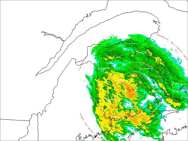
I just imported this image from the Chipman station in New Brunswick. As you can see, the outer red ring is visible as are the inner white rings. If you look carefully you can see the location names showing up too (I marked one in red).
If I could get rid of these I would be an extremely happy camper!!
The only thing I did was get rid of the outer Range Ring (red one) by editing the digatmos.rdy file changing the RANGERING=1 to RANGERING=0. I then changed all RNG settings to no more then 250. The other white range rings and city names are still present in mine but I think they are not as apparent because I am not zoomed in as much as you are in your example.
I am hoping Tim continues to develop this feature as us who live near the border have a need to be able to composite these radars "cleanly".