I believe I had some difficulty earlier last year over this problem, and while I did get help, now it's not working for me as it was. I need to get this up and running for the severe weather season start in April.
Please contact me offlist at "forecaster@charter.net"
Randy
Re: radar animation using DA WS
-
Hendricusl
- Member
- Posts: 22
- Joined: Sun Nov 23, 2003 9:29 pm
- Location: Caribou, Maine USA
- Contact:
-
Jon Wright
- Member
- Posts: 57
- Joined: Tue Mar 23, 2004 1:59 pm
- Location: SE Oklahoma
-
tornadoforecaster
Okay, here is the script, without the "blanks" in it. The problem is that the maps it should be using are not being used. Instead, the grey outlines of states without counties are being used.
load,C:\Program Files\DigitalAtmosphereWS\radarloop\Stevens Point\arx100base.dmf
RADAR,BREF2,ARX GRB MPX
stamp
export,C:\Program Files\DigitalAtmosphereWS\radarloop\Stevens Point\baseradararx100.gif
load,C:\Program Files\DigitalAtmosphereWS\radarloop\Stevens Point\grb100base.dmf
RADARPLOT
stamp
export,C:\Program Files\DigitalAtmosphereWS\radarloop\Stevens Point\baseradargrb100.gif
load,C:\Program Files\DigitalAtmosphereWS\radarloop\Stevens Point\regionalbase.dmf
RADARPLOT
stamp
export,C:\Program Files\DigitalAtmosphereWS\radarloop\Stevens Point\baseradarregional.gif
SPAWN,C:\Program Files\DigitalAtmosphereWS\radarloop\Stevens Point\arx100.bat,,1
SPAWN,C:\Program Files\DigitalAtmosphereWS\radarloop\Stevens Point\grb100.bat,,1
SPAWN,C:\Program Files\DigitalAtmosphereWS\radarloop\Stevens Point\regional100.bat,,1
load,C:\Program Files\DigitalAtmosphereWS\radarloop\Stevens Point\arx100base.dmf
RADAR,BVEL2,ARX GRB MPX
stamp
export,C:\Program Files\DigitalAtmosphereWS\radarloop\Stevens Point\basevelarx100.gif
load,C:\Program Files\DigitalAtmosphereWS\radarloop\Stevens Point\grb100base.dmf
RADARPLOT
stamp
export,C:\Program Files\DigitalAtmosphereWS\radarloop\Stevens Point\basevelgrb100.gif
load,C:\Program Files\DigitalAtmosphereWS\radarloop\Stevens Point\regionalbase.dmf
RADARPLOT
stamp
export,C:\Program Files\DigitalAtmosphereWS\radarloop\Stevens Point\basevelregional.gif
SPAWN,C:\Program Files\DigitalAtmosphereWS\radarloop\Stevens Point\arxvel100.bat,,1
SPAWN,C:\Program Files\DigitalAtmosphereWS\radarloop\Stevens Point\grbvel100.bat,,1
SPAWN,C:\Program Files\DigitalAtmosphereWS\radarloop\Stevens Point\regionalvel100.bat,,1
load,C:\Program Files\DigitalAtmosphereWS\radarloop\Stevens Point\arx100base.dmf
RADAR,OHP,ARX GRB MPX
stamp
export,C:\Program Files\DigitalAtmosphereWS\radarloop\Stevens Point\basepreciparx100.gif
load,C:\Program Files\DigitalAtmosphereWS\radarloop\Stevens Point\grb100base.dmf
RADARPLOT
stamp
export,C:\Program Files\DigitalAtmosphereWS\radarloop\Stevens Point\baseprecipgrb100.gif
load,C:\Program Files\DigitalAtmosphereWS\radarloop\Stevens Point\regionalbase.dmf
RADARPLOT
stamp
export,C:\Program Files\DigitalAtmosphereWS\radarloop\Stevens Point\baseprecipregional.gif
SPAWN,C:\Program Files\DigitalAtmosphereWS\radarloop\Stevens Point\arxprecip100.bat,,1
SPAWN,C:\Program Files\DigitalAtmosphereWS\radarloop\Stevens Point\grbprecip100.bat,,1
SPAWN,C:\Program Files\DigitalAtmosphereWS\radarloop\Stevens Point\regionalprecip100.bat,,1
timeron
I need it to use maps with county outlines as well as cities plotted as well.
Any thoughts?
Randy
load,C:\Program Files\DigitalAtmosphereWS\radarloop\Stevens Point\arx100base.dmf
RADAR,BREF2,ARX GRB MPX
stamp
export,C:\Program Files\DigitalAtmosphereWS\radarloop\Stevens Point\baseradararx100.gif
load,C:\Program Files\DigitalAtmosphereWS\radarloop\Stevens Point\grb100base.dmf
RADARPLOT
stamp
export,C:\Program Files\DigitalAtmosphereWS\radarloop\Stevens Point\baseradargrb100.gif
load,C:\Program Files\DigitalAtmosphereWS\radarloop\Stevens Point\regionalbase.dmf
RADARPLOT
stamp
export,C:\Program Files\DigitalAtmosphereWS\radarloop\Stevens Point\baseradarregional.gif
SPAWN,C:\Program Files\DigitalAtmosphereWS\radarloop\Stevens Point\arx100.bat,,1
SPAWN,C:\Program Files\DigitalAtmosphereWS\radarloop\Stevens Point\grb100.bat,,1
SPAWN,C:\Program Files\DigitalAtmosphereWS\radarloop\Stevens Point\regional100.bat,,1
load,C:\Program Files\DigitalAtmosphereWS\radarloop\Stevens Point\arx100base.dmf
RADAR,BVEL2,ARX GRB MPX
stamp
export,C:\Program Files\DigitalAtmosphereWS\radarloop\Stevens Point\basevelarx100.gif
load,C:\Program Files\DigitalAtmosphereWS\radarloop\Stevens Point\grb100base.dmf
RADARPLOT
stamp
export,C:\Program Files\DigitalAtmosphereWS\radarloop\Stevens Point\basevelgrb100.gif
load,C:\Program Files\DigitalAtmosphereWS\radarloop\Stevens Point\regionalbase.dmf
RADARPLOT
stamp
export,C:\Program Files\DigitalAtmosphereWS\radarloop\Stevens Point\basevelregional.gif
SPAWN,C:\Program Files\DigitalAtmosphereWS\radarloop\Stevens Point\arxvel100.bat,,1
SPAWN,C:\Program Files\DigitalAtmosphereWS\radarloop\Stevens Point\grbvel100.bat,,1
SPAWN,C:\Program Files\DigitalAtmosphereWS\radarloop\Stevens Point\regionalvel100.bat,,1
load,C:\Program Files\DigitalAtmosphereWS\radarloop\Stevens Point\arx100base.dmf
RADAR,OHP,ARX GRB MPX
stamp
export,C:\Program Files\DigitalAtmosphereWS\radarloop\Stevens Point\basepreciparx100.gif
load,C:\Program Files\DigitalAtmosphereWS\radarloop\Stevens Point\grb100base.dmf
RADARPLOT
stamp
export,C:\Program Files\DigitalAtmosphereWS\radarloop\Stevens Point\baseprecipgrb100.gif
load,C:\Program Files\DigitalAtmosphereWS\radarloop\Stevens Point\regionalbase.dmf
RADARPLOT
stamp
export,C:\Program Files\DigitalAtmosphereWS\radarloop\Stevens Point\baseprecipregional.gif
SPAWN,C:\Program Files\DigitalAtmosphereWS\radarloop\Stevens Point\arxprecip100.bat,,1
SPAWN,C:\Program Files\DigitalAtmosphereWS\radarloop\Stevens Point\grbprecip100.bat,,1
SPAWN,C:\Program Files\DigitalAtmosphereWS\radarloop\Stevens Point\regionalprecip100.bat,,1
timeron
I need it to use maps with county outlines as well as cities plotted as well.
Any thoughts?
Randy
-
tornadoforecaster
Les,
I think I have them on my hard drive yet. Do you need them? If so, then write me off list and I'll send them to you.
forecaster@charter.net
Randy
I think I have them on my hard drive yet. Do you need them? If so, then write me off list and I'll send them to you.
forecaster@charter.net
Randy
-
Weasel
Les, Tim Vasquez posted this a while back. It explains the batch file and what else you will need for it to work properly.Les wrote:Without the .bat files, there's not much anybody can do with your script.
Are they available for download anywhere?
Les
Pat
-------------------------------------------------------------------------------
Digital Atmosphere does not have an animator built in yet, but you can do it in an automated manner like this.
Write a batch file in MS-DOS containing these commands.
Code:
composite -compose xor -dissolve 50 basemap.gif baseradar.gif gif:radar.gif
copy frame1.gif frame0.gif
copy frame2.gif frame1.gif
copy frame3.gif frame2.gif
copy radar.gif frame3.gif
convert -delay 50 frame0.gif -delay 50 frame1.gif -delay 50 frame2.gif -delay 200 frame3.gif -loop 0 radarloop.gif
(be careful, there should be only six lines above]http://www.imagemagick.org/script/index.php[/url]
But lucky for you, I've thinned out the mess of distributables to just a dozen key files, which you can get at:
http://www.weathergraphics.com/dl/convert.zip
Unzip these to the SAME directory where you will be running the batch file (or put in their own directory and change the Windows path in your system setup to point to that directory).
The ImageMagick library is quite powerful, and there's no limit to what it can do with a good batch file. With the radar upload hack I posted earlier, you can put animated radar on your server quite easily... running your own Weathertap site.
Tim
-
Weasel
This is the radar upload hack Tim mentioned in the above
Pat
--------------------------------------------------------------------
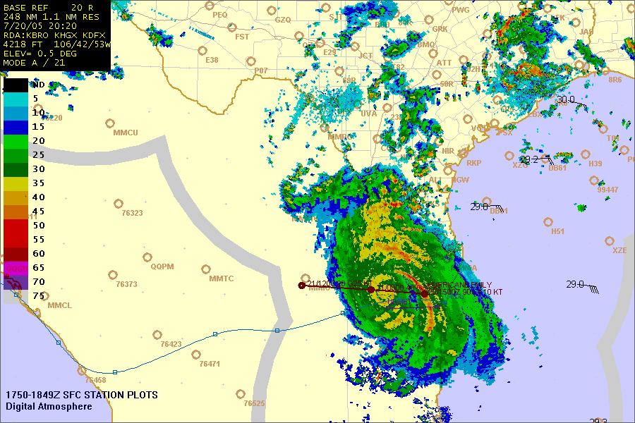
A few days ago we were posting hourly maps, compositing US and Mexican radar looking like this:
http://www.weathergraphics.com/images/emily2007.gif
Here's how it was done:
A script file with these contents was executed in the Digital Atmosphere schedule hourly:
Code:
BLANK
ERASE
IMPORTRADAR
ERASE
RADAR,br248,bro hgx dfx epz
DOWNLOAD
HURRICANE
HURRMODEL,2
PRODUCT,plf,0,Wind and SST
EXPORT,c:\st\special\weathermap.gif
EXPORT,c:\st\special\emily@HHZ@MMZ.gif
SPAWN,c:\st\special\process.bat,,1
The spawn command executed a batch file at c:\st\special\process.bat with this:
Code:
ftp -s:upload.scr http://www.stormtrack.org
This executed the following script, upload.scr:
Code:
ourlogin
ourpassword
cd stormtrack.org/special
bin
hash
prompt
mput weathermap.gif
bye
Pat
--------------------------------------------------------------------
A few days ago we were posting hourly maps, compositing US and Mexican radar looking like this:
http://www.weathergraphics.com/images/emily2007.gif
Here's how it was done:
A script file with these contents was executed in the Digital Atmosphere schedule hourly:
Code:
BLANK
ERASE
IMPORTRADAR
ERASE
RADAR,br248,bro hgx dfx epz
DOWNLOAD
HURRICANE
HURRMODEL,2
PRODUCT,plf,0,Wind and SST
EXPORT,c:\st\special\weathermap.gif
EXPORT,c:\st\special\emily@HHZ@MMZ.gif
SPAWN,c:\st\special\process.bat,,1
The spawn command executed a batch file at c:\st\special\process.bat with this:
Code:
ftp -s:upload.scr http://www.stormtrack.org
This executed the following script, upload.scr:
Code:
ourlogin
ourpassword
cd stormtrack.org/special
bin
hash
prompt
mput weathermap.gif
bye