|
Surface Archives
1961-2002
There is absolutely no greater, more comprehensive, more flexible
collection of historical surface observations than Surface Archives.
If you've ever wanted to do case studies on old weather events,
re-explore mesoscale aspects of storm events in the 1970s,
or you simply enjoy thumbing through old weather maps, this package
will be sure to excite you!
Surface Archives is packed with nearly half a billion weather observations,
allowing you to plot detailed weather charts of
the United States and North America from 1961 to 2002! Create
maps hour by hour, day by day, for any historical weather day! See the
maps at the time you were born! Recreate the patterns that led to
destructive weather events! Correlate your weather logs to the actual
maps! Investigate your own case studies! Look at massive snowstorms in
detail!
For those of you familiar with our older 2-disc Surface Archives
sold from 1997 to 2002, this is a major expansion of the former product.
It nearly quadruples the number of stations available from 1977 to 1990
and fills in all the years from 1991 to present!
A 25% discount is available for registered users of the old product.
|
"I just ordered the Archives bundle and I got it today.
I have to say that it is an AWESOME set of data and
worth every penny. You have done a terrific job
with this and coupled with Digital Atmosphere...
well, there isn't anything out there like it!"
|
|
Technical specifications
For each hour of each date, there is a single file containing all
surface observations. All of this data is in standardized reporting
format (METAR or SA) which can be decoded by hand or by display
programs such as GEMPAK, Weathergraphix, and Digital Atmosphere.
The discs include all 1961-2002 content, with variations
as follows:
2001-current period. Each file contains approximately 2,000
weather observations for the world, sorted by date and time.
|
COVERAGE: About 2,000 stations throughout the world.
Click to see coverage map for North America.
SOURCE: Direct capture from observation datastreams.
The data is provided exactly as received, so remarks and
coded groups are preserved intact.
LIMITATIONS: None.
|
1977-2001 period. Each file contains approximately 1,000
weather observations for North America, sorted by date and time.
There is also a text file for every month containing highs/lows and
precipitation totals at 12 hour intervals for about 50% of the
stations. See a June 1980 example for
max/min temperature and
precipitation.
|
COVERAGE: About 1,000 stations in North America
(including Canada and some of Mexico).
Click to see coverage map or
see the detailed station list.
ACTUAL SAMPLE. Complete sample file for
6/27/80 2200 UTC (at the time
of the 1980 Texas heat wave). Corresponding
plot for same data time using Digital Atmosphere
(not included).
SOURCE NOAA/TDL Hourly Observation Tapes.
The hourly data, upon capture, were decoded into various fields,
packed, and offloaded to tape in a packed, tabular format.
The resulting data, 8.6 GB in size,
was converted to METAR format by Weather Graphics
Technologies using proprietary software developed inhouse.
Coded 1xxxxxxxx groups are included to preserve the accuracy
of original Fahrenheit values.
LIMITATIONS: Remarks and coded data were not preserved
in the source data. Scattered cloud layers from 1977-1978 are
assigned a height of 250 (25,000 ft) due to NOAA/TDL tape corruption.
Some max/min temperature coded groups are missing from certain stations.
3-letter identifiers are converted to 4-letter ICAO by prefixing with
K (United States) or C (Canada); the end user is responsible for
maintaining a valid station list.
Alaskan and Hawaiian stations which are now defunct and were never assigned
a P___ ICAO are assigned an arbitrary KX__ identifer (documentation
is provided on disk).
|
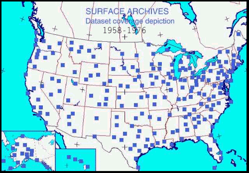
1961-1976 period. Each file contains about 237 observations
for the United States (including Alaska and Hawaii), sorted by date and time.
|
FORMAT:
SAO
(surface airways observation) format.
COVERAGE: 237 observations in the United States.
Click to see a coverage map.
SOURCE: NOAA/NCDC SAMSON data archives.
SAMSON is NCDC's hourly solar radiation product.
All data has been converted to SAO (airways) format by Weather
Graphics Technologies using proprietary software developed inhouse.
LIMITATIONS: Remarks and coded data were not preserved
in the source data.
Since the original SAMSON data strips away
sea-level pressure, this is estimated as a direct conversion from
station pressure without r-values or r-factors, so it must
be used with caution. Altimeter setting is accurately computed
from direct conversion from station pressure, and is not subject
to this data limitation.
|
Ordering
Surface Archives is offered in two flavors:
SURFACE ARCHIVES LITE ($89.00) -- Contains only
00Z and 12Z data on 2 CD-ROM discs. Recommended for the casual
weather hobbyist.
SURFACE ARCHIVES PROFESSIONAL ($199.00) -- Contains
all data every hour on 6 CD-ROM discs. Recommended for researchers,
active meteorologists, and dedicated hobbyists.
BUNDLE ($275.00) -- Get Surface Archives
Professional bundled with Upper Archives and save $75!
UPGRADING -- Registered owners of the older Surface Archives
package may receive a 25% discount by requesting this in the comments
area of the online order form. We will verify the information and
contact you if there is a problem.
Return to main page
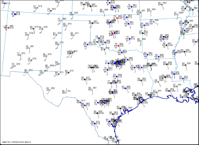
Sample image for May 7, 1986 at 1800 UTC using Surface Archives 1961-2002
|
