Forecast Center
January/February 2002
by TIM VASQUEZ / www.weathergraphics.com
|
This article is a courtesy copy placed on the author's website for educational purposes as permitted by written agreement with Taylor & Francis. It may not be distributed or reproduced without express written permission of Taylor & Francis. More recent installments of this article may be found at the link which follows. Publisher's Notice: This is a preprint of an article submitted for consideration in Weatherwise © 2002 Copyright Taylor & Francis. Weatherwise magazine is available online at: http://www.informaworld.com/openurl?genre=article&issn=0043-1672&volume=55&issue=1&spage=58. |
PART ONE: The Puzzle
When winter settles over North America, frigid air masses form in the northern regions of Canada and sink southward. The result is a classic frontal system that tends to move southeastward into the United States. In this puzzle we present such an example from early November 2001.
Draw isobars every four millibars (992, 996, 1000, 1004, etc.) using the plot model example at the lower right as a guide. As the plot model indicates, the actual millibar value for plotted pressure (xxx) is 10xx.x mb when the number shown is below 500, and 9xx.x when it is more than 500. For instance, 027 represents 1002.7 mb and 892 represents 989.2 mb. Therefore, when one station reports 074 and a nearby one shows 086, the 1008 mb isobar will be found halfway between the stations.
Hint for beginners: You can expect to find one cold front and one warm front. You'll also find at least one distinct low and high pressure area.
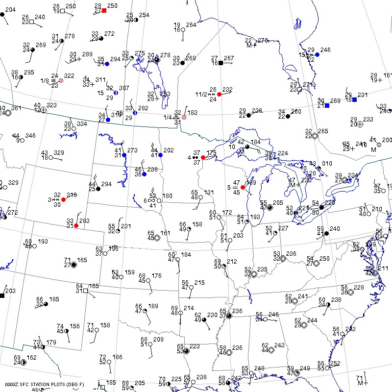
Click to enlarge

* * * * *
Scroll down for the solution
* * * * *
PART TWO: The Solution
The map reveals a classic cold front sweeping through the Northern Plains. These fronts are sometimes referred to as "Alberta clippers" since they move swiftly southeastward from the western provinces of Canada. They usually begin moving more easterly as they reach the Midwest states.
The character of the cold front is revealed by looking at the high pressure area that drives it. In this case, the high pressure area is rather small and is confined to the Montana area. This contrasts with the powerful cold blasts that occasionally put the United States in the deep freeze. These events are typically created by large high pressure areas which cover substantial portions of Canada or the northern United States. The presence of considerable snow cover is instrumental in reinforcing the brutal cold by reflecting incoming radiation from the sun and insulating the air mass from ground warmth.
When forecasting precipitation associated with these classic frontal systems, forecasters will often look at the strength of wind across the warm front and the amount of cold air to its north, which can combine to produce "overrunning" (isentropic lift) and wet, foggy weather. Forecasters will also check surface maps for high dewpoints that might combine with forcing along the cold front to produce showers or thunderstorms. Finally, the system's overall movement, the instability through the region, and upper-level divergence areas are examined to pinpoint the extent and location of the strongest precipitation.
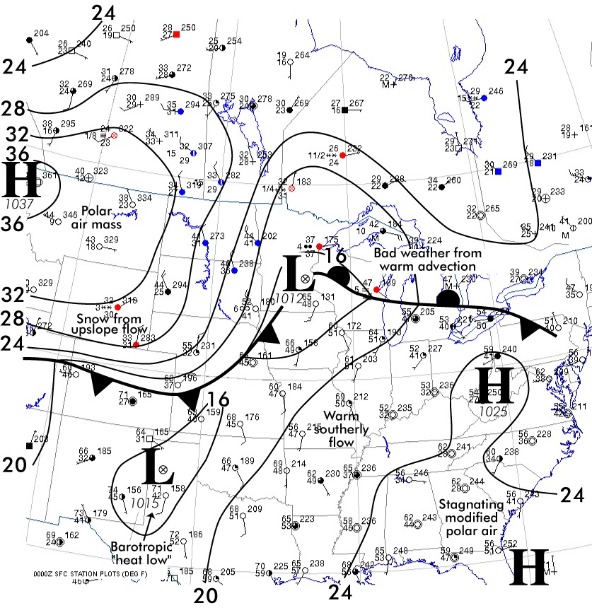
Click to enlarge
©2002 Taylor & Francis
All rights reserved