Forecast Center
May/June 2004
by TIM VASQUEZ / www.weathergraphics.com
|
This article is a courtesy copy placed on the author's website for educational purposes as permitted by written agreement with Taylor & Francis. It may not be distributed or reproduced without express written permission of Taylor & Francis. More recent installments of this article may be found at the link which follows. Publisher's Notice: This is a preprint of an article submitted for consideration in Weatherwise © 2004 Copyright Taylor & Francis. Weatherwise magazine is available online at: http://www.informaworld.com/openurl?genre=article&issn=0043-1672&volume=57&issue=3&spage=82. |
PART ONE: The Puzzle
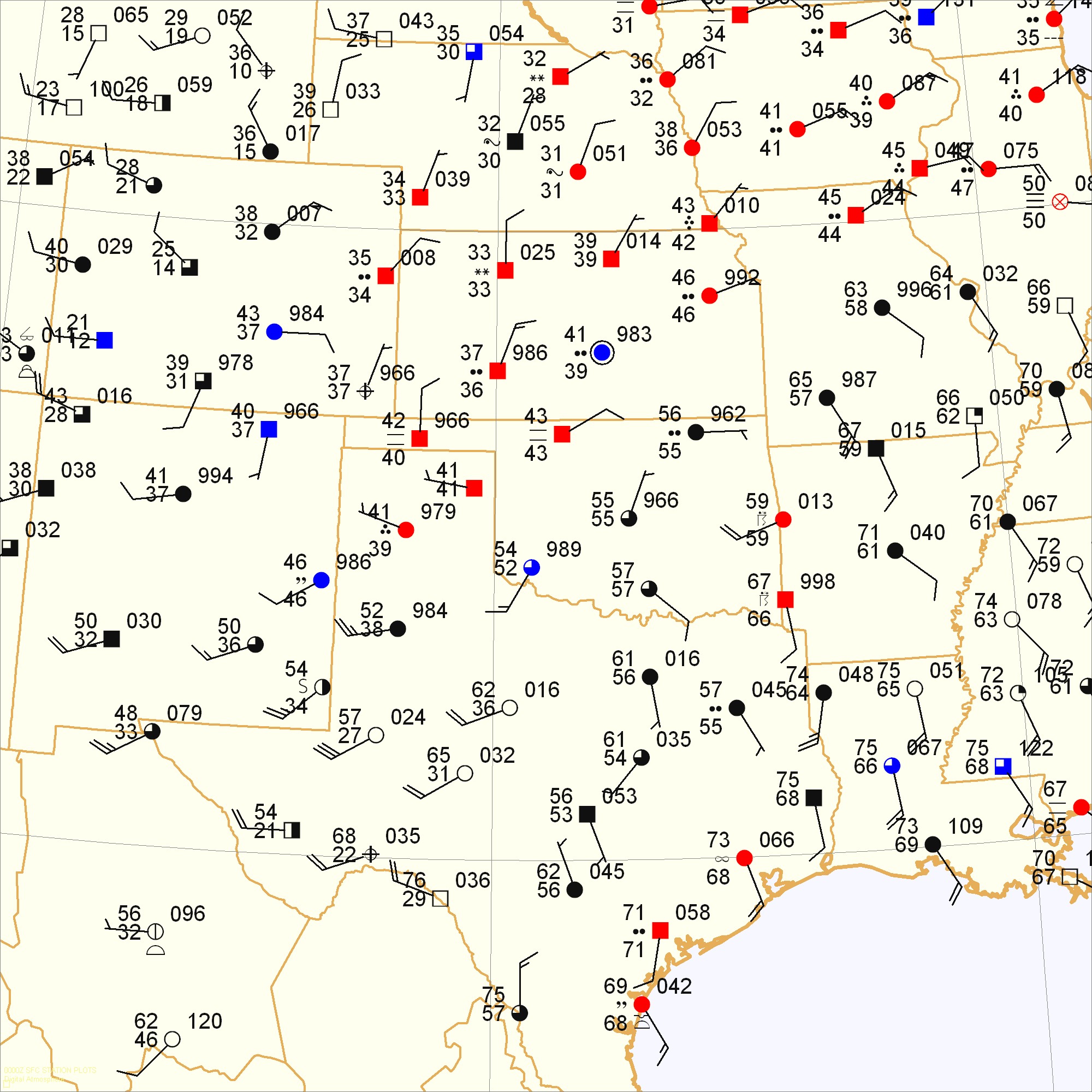
Vigorous low pressure systems and long squall lines are a staple of springtime forecasting in the United States. In this issue we'll look at both. Squall lines are essentially a long line of thunderstorms, large enough to leave their mark on surface charts. They can create complicated patterns such as bubble highs and wake lows. Not surprisingly, this issue's puzzle promises to be somewhat more challenging than usual!
Draw isobars every four millibars (992, 996, 1000, 1004, etc.) using the plot model example at the lower right as a guide. As the plot model indicates, the actual millibar value for plotted pressure (xxx) is 10xx.x mb when the number shown is below 500, and 9xx.x when it is more than 500. For instance, 027 represents 1002.7 mb and 892 represents 989.2 mb. Therefore, when one station reports 074 and a nearby one shows 086, the 1008 mb isobar will be found halfway between the stations.
Click to enlarge

* * * * *
Scroll down for the solution
* * * * *
PART TWO: The Solution
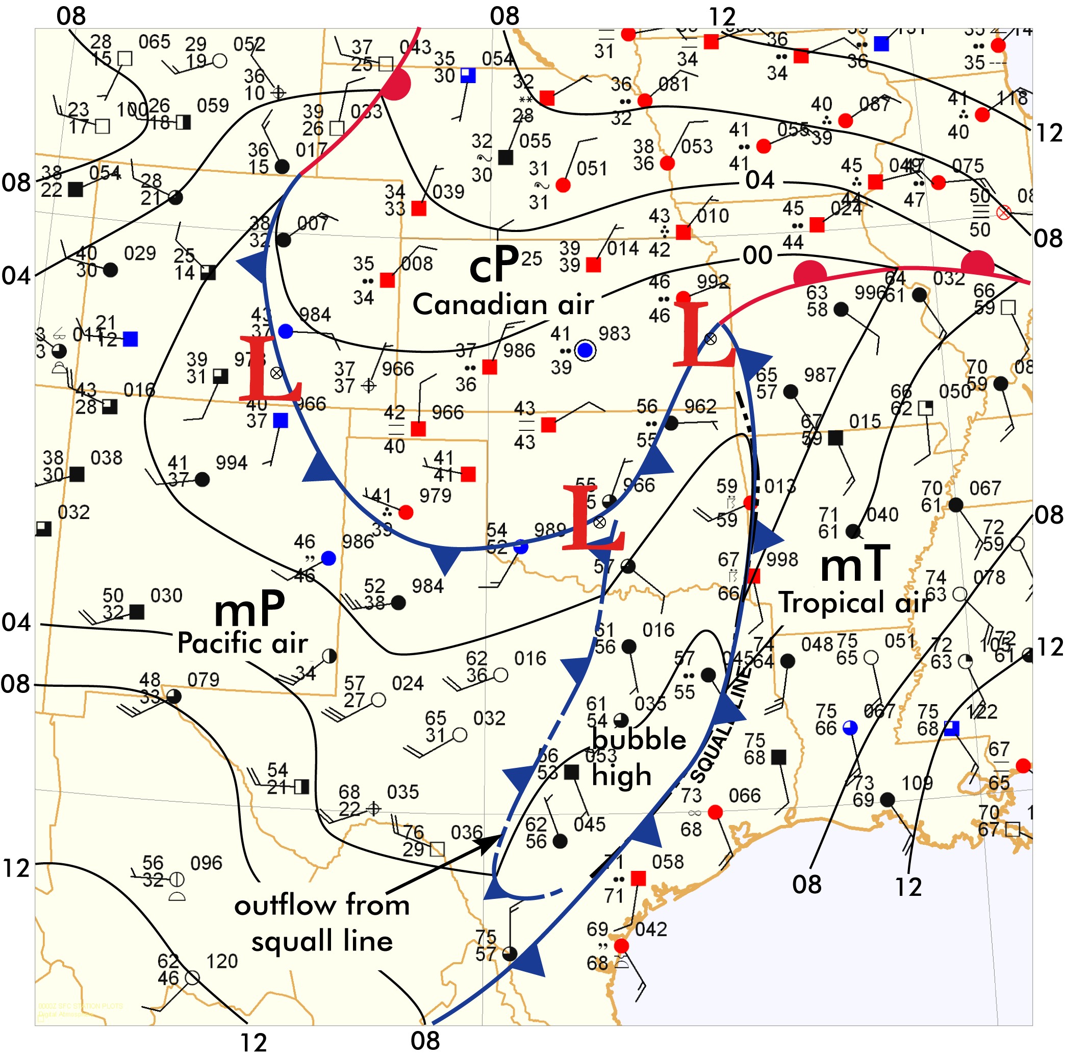
It was a stormy day across the Great Plains on the evening of March 4, 2004. Close scrutiny of the weather map shows three distinct air masses across the region. First is a warm, tropical air mass in Louisiana and Arkansas. It is marked mT (maritime tropical, its classical nomenclature) to reflect its equatorial nature. Second is an area of gusty west winds in west Texas and New Mexico. This air originates from Pacific high pressure further to the west, and is marked mP (maritime polar). Third is Canadian air in the northern Plains, signified by very cold temperatures and north winds. It is marked cP (continental polar).
A deep storm system such as the one shown here departing the Rocky Mountains draws Canadian air south and Pacific air eastward, creating the dual cold-front structure shown here. Such a pattern is extremely common. In most cases, the Canadian and Pacific air masses fuse together and the Pacific front becomes dominant as the surface low approaches the Appalachian region.
One unusual pattern has made its mark on the map, and it will probably give readers the most trouble! In the vicinity of the Texas squall line, between the Pacific and tropical air masses, is a region of chaotic wind direction and higher pressure. This is actually the bubble high, or mesohigh, a very large area of rain-cooled air caused by the squall line's precipitation and downdraft. There is always a divergent appearance to the winds in such an air mass. While the leading edge marks the squall line itself, the trailing edge is often easily found on surface maps, as shown here with a dashed cold front line. It is sometimes called a wake low. It moves east with the squall line as the gusty postfrontal air invades and replaces the rain-cooled air.
One interesting paradox is shown that often stumps beginners. The Pacific air mass in southwest Texas is dry, with 20 and 30-degree dewpoints. Yet the Canadian air mass in the northern Plains shows drizzle and 30 to 40-degree dewpoints. Why is the maritime air mass drier than the continental one? They have both been modified from their original state. The moist Pacific air mass has dried due to adiabatic warming as it descends the Sierra Nevada and Rocky Mountains. The dry Canadian air mass was infused with moisture from the tropical air wrapping into the system aloft and precipitating.
The squall line is already a focus for severe weather, and three tornado watch boxes are in effect ahead of it. Also, the warm front ahead of the weather system can be an important location for thunderstorms. Fortunately it was dormant this evening, but if moisture is in place a warm front can provide formidable shear profiles that support numerous tornadic storms.
Click to enlarge
©2004 Taylor & Francis
All rights reserved