Forecast Center
September/October 2004
by TIM VASQUEZ / www.weathergraphics.com
|
This article is a courtesy copy placed on the author's website for educational purposes as permitted by written agreement with Taylor & Francis. It may not be distributed or reproduced without express written permission of Taylor & Francis. More recent installments of this article may be found at the link which follows. Publisher's Notice: This is a preprint of an article submitted for consideration in Weatherwise © 2004 Copyright Taylor & Francis. Weatherwise magazine is available online at: http://www.informaworld.com/openurl?genre=article&issn=0043-1672&volume=57&issue=5&spage=98. |
PART ONE: The Puzzle
To many Americans, Alaska epitomizes the crisp, raw beauty of North America's wilderness. The mind conjures up images of snow-covered peaks jutting upward into deep blue skies. However in early summer 2004, all was not well. Temperatures soared upward towards 90 degrees, and skies throughout much of the interior region became clouded with smoke. An Anchorage Daily News story reported, "The hot summer sun melted into a dim red glow in a foul, milky sky. Workers at big-box stores donned respirator masks and grimaced at the stink."
Draw isobars every four millibars (992, 996, 1000, 1004, etc.) using the plot model example at the lower right as a guide. As the plot model indicates, the actual millibar value for plotted pressure (xxx) is 10xx.x mb when the number shown is below 500, and 9xx.x when it is more than 500. For instance, 027 represents 1002.7 mb and 892 represents 989.2 mb. Therefore, when one station reports 074 and a nearby one shows 086, the 1008 mb isobar will be found halfway between the stations.
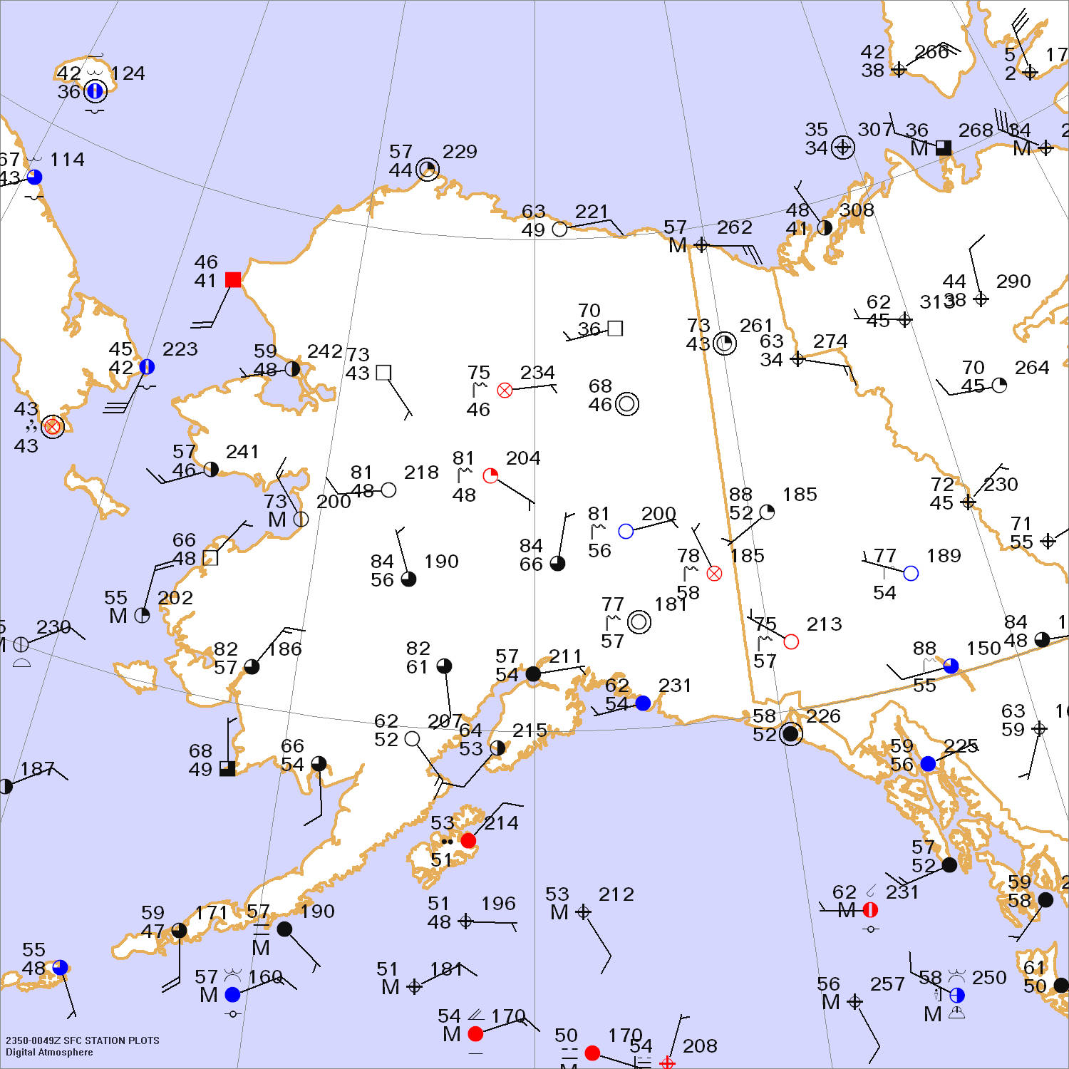
Click to enlarge

* * * * *
Scroll down for the solution
* * * * *
PART TWO: The Solution
It was the afternoon of June 27, 2004. Forest fires had been burning for over a week through much of the eastern Alaskan interior. However as an upper-level ridge took hold, atmospheric winds became light and variable. This allowed the smoke to concentrate and disperse slowly throughout central Alaska, affecting the large city of Fairbanks as well as a number of smaller towns. To compound matters further, an atmospheric inversion kept the smoke confined to a layer below about 6,000 ft. Visibilities were less than a mile at official weather observing sites, and air quality alerts were issued.
The forest fires were caused by a combination of lightning strikes and very dry conditions. Surprisingly, thunderstorms are quite common in the Alaskan interior and Yukon regions during the summer months. They are rarely severe, but the lightning easily touches off fires in the spruce-covered taiga. About half a million acres are burned on a typical year, and any given spot can be expected to be burned once every 60 to 100 years. The fires are beneficial for the long-term health of the Alaskan ecosystem, but often reach homes and towns.
The surface map shows high pressure covering the Arctic and Pacific Ocean basins. This is quite typical for the summer months, since the ocean waters are relatively cool. The high pressure's divergent winds diffuses temperature contrasts, restraining the development of frontal systems. Meanwhile the landmasses are heated strongly by the sun. The axis of strongest heating creates a thermal trough or a thermal low, much like that often found in the southwest deserts of the United States. The convergence of winds into this trough, combined with orographic lift across the tall mountain ranges, hills, and ridges, provides a broad focus for showers and thunderstorm development. The trough tends to oscillate and move from day to day depending on the weather patterns.
Relief from the smoke can only come when the inversion weakens and atmospheric winds strengthen. These factors came into play by early July as the Arctic Ocean high built southward into Alaska, but unfortunately the fires continued to burn, slowed marginally by the cooler temperatures and more humid air. The 2004 season was destined to go on the record books alongside the fire-ravaged years of 1940 and 1969.
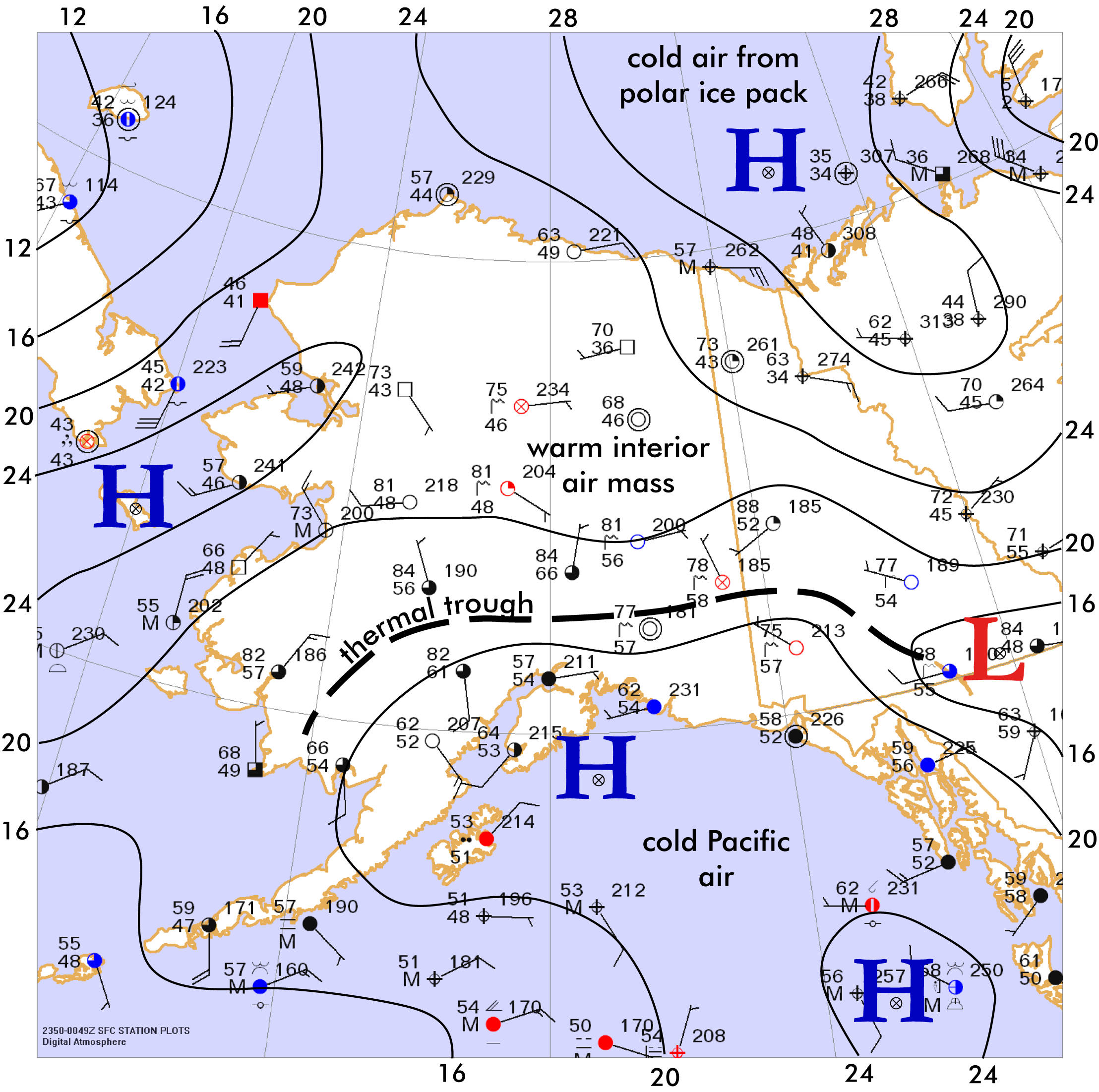
Click to enlarge
©2004 Taylor & Francis
All rights reserved