Forecast Center
July/August 2006
by TIM VASQUEZ / www.weathergraphics.com
|
This article is a courtesy copy placed on the author's website for educational purposes as permitted by written agreement with Taylor & Francis. It may not be distributed or reproduced without express written permission of Taylor & Francis. More recent installments of this article may be found at the link which follows. Publisher's Notice: This is a preprint of an article submitted for consideration in Weatherwise © 2006 Copyright Taylor & Francis. Weatherwise magazine is available online at: http://www.informaworld.com/openurl?genre=article&issn=0043-1672&volume=59&issue=4&spage=82. |
PART ONE: The Puzzle
May is when patterns begin transitioning into those of summer. The jet stream recedes northward, the Bermuda high begins expanding into the southeastern United States, and weak frontal systems march across the northern states. This puzzle, however, reveals an interesting surprise: winterlike patterns in mid-May. The unusual setup will reveal an important building block of weather forecasting.
Draw isobars every eight millibars (1008, 1000, 992, etc.) using the plot model example at the lower right as a guide. As the plot model indicates, the actual millibar value for plotted pressure (xxx) is 10xx.x mb when the number shown is below 500, and 9xx.x when it is more than 500. For instance, 027 represents 1002.7 mb and 892 represents 989.2 mb. Therefore, when one station reports 074 and a nearby one shows 086, the 1008 mb isobar will be found halfway between the stations.
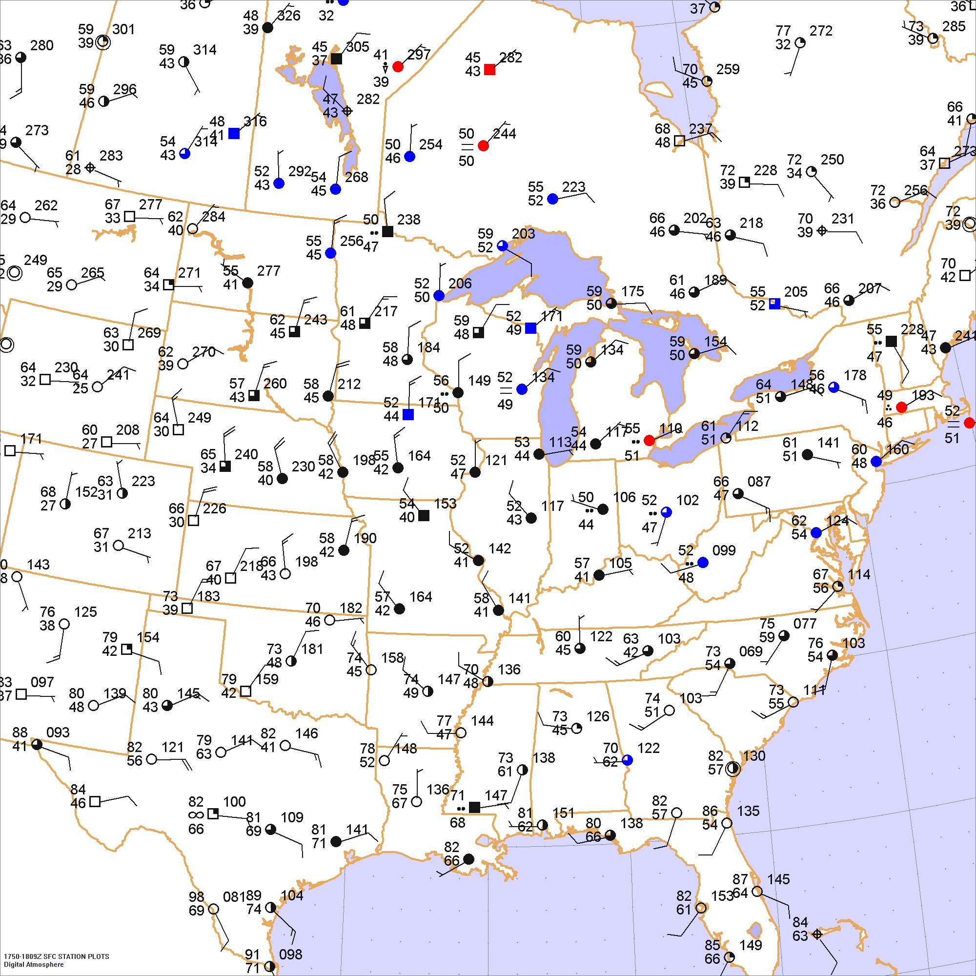
Click to enlarge

* * * * *
Scroll down for the solution
* * * * *
PART TWO: The Solution
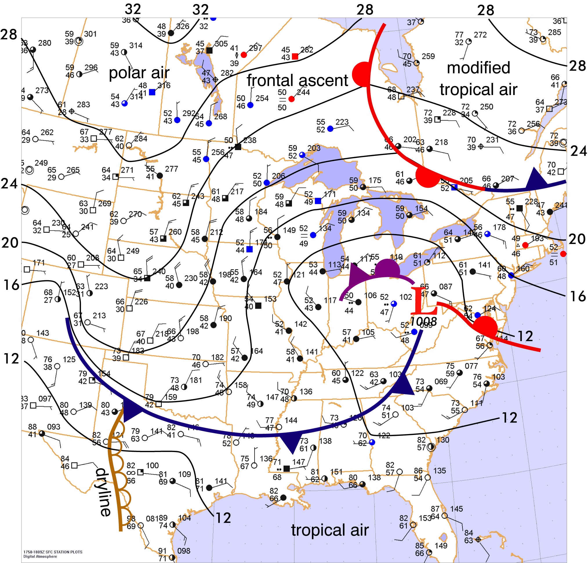
The afternoon of May 14, 2006 was the day that a Massachusetts resident, shivering in dreary weather and 50-degree temperatures, could drive north into Quebec and emerge into bright, summerlike conditions. This freakish pattern was caused by a very large low pressure area that was more typical of something seen in March. It had already stalled in the Great Lakes area for two days and was not expected to budge for almost a week.
This huge, sluggish weather system provided a impressive demonstration of how a large low pressure area can draw air masses from many different source regions into one area, the convergence sharpening the temperature contrasts. Tropical air from the Gulf of Mexico moved northward up the Atlantic seaboard. Stagnant polar air in New England was drawn northwestward. Warm, modified tropical air already in Quebec moved around the northern periphery of the low. Cold polar air from the Northwest Territories spiralled southward into the Great Plains.
It certainly might sound that the result is a forecaster's nightmare: a mix of air masses that grows more complicated day by day. Interestingly, though, a process of simplification has already begun. As the air masses spiral together, the warmest ones are displaced aloft, leaving only the coldest air masses at the surface. The process is called occlusion. As occlusion continues, the temperature contrasts are dispelled and energy is removed from the low pressure system, causing the inflow of different air masses to subside. The occlusion can still be seen at the surface, as shown by the purple line in northern Indiana and Ohio where the coldest air masses meet. The two air masses had been drawn inward by an old low pressure area that had been active in Illinois. However this occluded front, too, dissipates in a matter of days as the two remaining cold air masses spiral around each other and homogenize.
This is not the end for the weather system, however. New development often occurs away from the occlusion where fresh cold air and warm air are in contact with one another. This process is called baroclinic development. In this example, baroclinic development has already taken place in the Appalachian region and a mature low is found in West Virginia. The new low pressure area will deepen, draw new air masses together yet again, and finally occlude and dissipate. This is a cyclic pattern: the life cycle of an extratropical low.
Click to enlarge
©2006 Taylor & Francis
All rights reserved