Forecast Center
March/April 2007
by TIM VASQUEZ / www.weathergraphics.com
|
This article is a courtesy copy placed on the author's website for educational purposes as permitted by written agreement with Taylor & Francis. It may not be distributed or reproduced without express written permission of Taylor & Francis. More recent installments of this article may be found at the link which follows. Publisher's Notice: This is a preprint of an article submitted for consideration in Weatherwise © 2007 Copyright Taylor & Francis. Weatherwise magazine is available online at: http://www.informaworld.com/openurl?genre=article&issn=0043-1672&volume=60&issue=2&spage=98. |
PART ONE: The Puzzle
In Seattle, the evening commute brings winds gusting out of the north with heavy snow. Tourists build snowmen on Oregon beaches. Idaho state troopers work dozens of accidents due to icy roads in the Boise area. What's going on? It's a rare outbreak of cold Canadian air in the western United States. In this issue we'll take a look at one of these spectacular weather events.
This weather map is for the midday hours in January. Draw isobars every eight millibars (1008, 1000, 992, etc.) using the plot model example at the lower right as a guide. As the plot model indicates, the actual millibar value for plotted pressure (xxx) is 10xx.x mb when the number shown is below 500, and 9xx.x when it is more than 500. For instance, 027 represents 1002.7 mb and 892 represents 989.2 mb. Therefore, when one station reports 074 and a nearby one shows 086, the 1008 mb isobar will be found halfway between the stations.
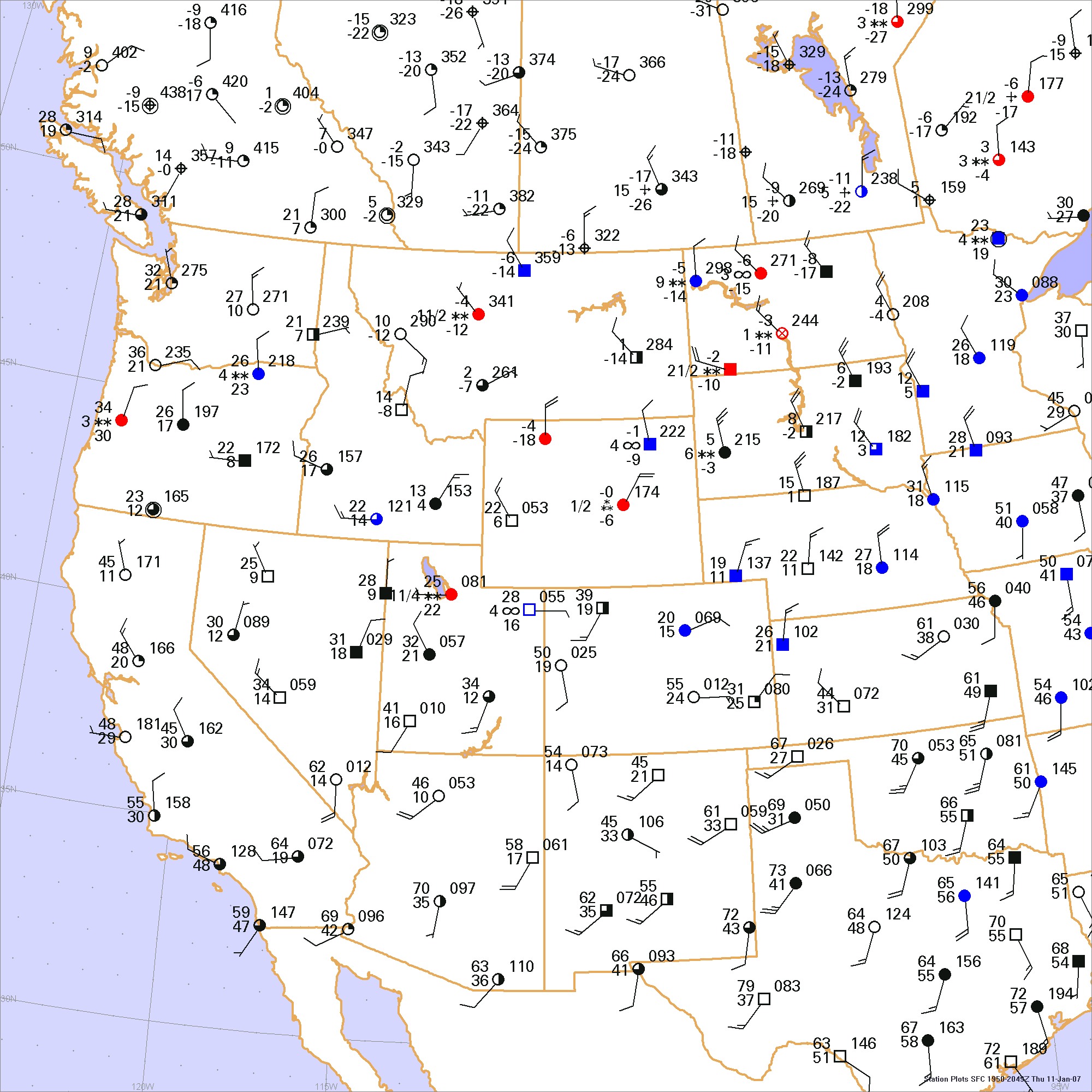
Click to enlarge

* * * * *
Scroll down for the solution
* * * * *
PART TWO: The Solution
The typical outbreak of cold Canadian air moves from the Yukon and Northwest Territories southeastward into the central United States, and is usually kept out of the Rocky Mountain region due to the barrier effect of this mountain chain. Cold weather that invades the Great Basin region and Pacific Northwest typically originates from stagnating air masses or from Pacific cold fronts that sweep southeastward. These air masses have a marine influence and are mild compared to their Canadian counterparts.
However on rare occasion, arctic air will infiltrate southwestward from British Columbia and Alberta into Washington, Oregon, Idaho, and points southward. A strong outbreak is rare, but the effects can be catastrophic. A strong outbreak on December 20-24, 1990 brought bitter cold to California and decimated the state's citrus industry.
In this issue's puzzle, we see conditions at noon on January 11, 2007. A strong, deep Canadian polar air mass has developed over British Columbia and was driving cold air southward through the western United States. Daytime highs remained in the 30s in Washington and Oregon. Further east, another portion of the arctic high was driving a Great Plains cold front southward. The eastern portion of these Canadian outbreaks are often much colder, and as a result, a portion of colder air was found working westward into Idaho.
It can actually be extremely difficult to keep track of air masses in the intermountain regions. The wide variations in terrain elevation require the forecaster to have an intimate knowledge of the region's topography and to understand the eccentricities of each weather station, as not all stations are at the same elevation and some may be in foothill areas or on mountain summits. It is especially important to monitor trends in temperature, wind, pressure, weather, and cloud cover at each station. A cold front in the western United States is often better identified by hour-to-hour changes, rather than what appears on the map. A few Internet weather sites, such as
What causes such incursions of arctic air into the western United States? A significant depth of cold air is necessary, and it takes strong or prolonged cooling in the Canadian regions to chill such a large volume of air. Many Great Plains outbreaks are associated with cold air depths of a few thousand feet, but Pacific Northwest outbreaks may be caused by a cold air mass up to 10,000 ft in depth. Also a steering current that guides the outbreak southwestward is another factor. On the date of this puzzle, northerly mid-tropospheric winds helped push 8,000 ft deep Canadian air southward from British Columbia, leading to the unusual weather event that unfolded.
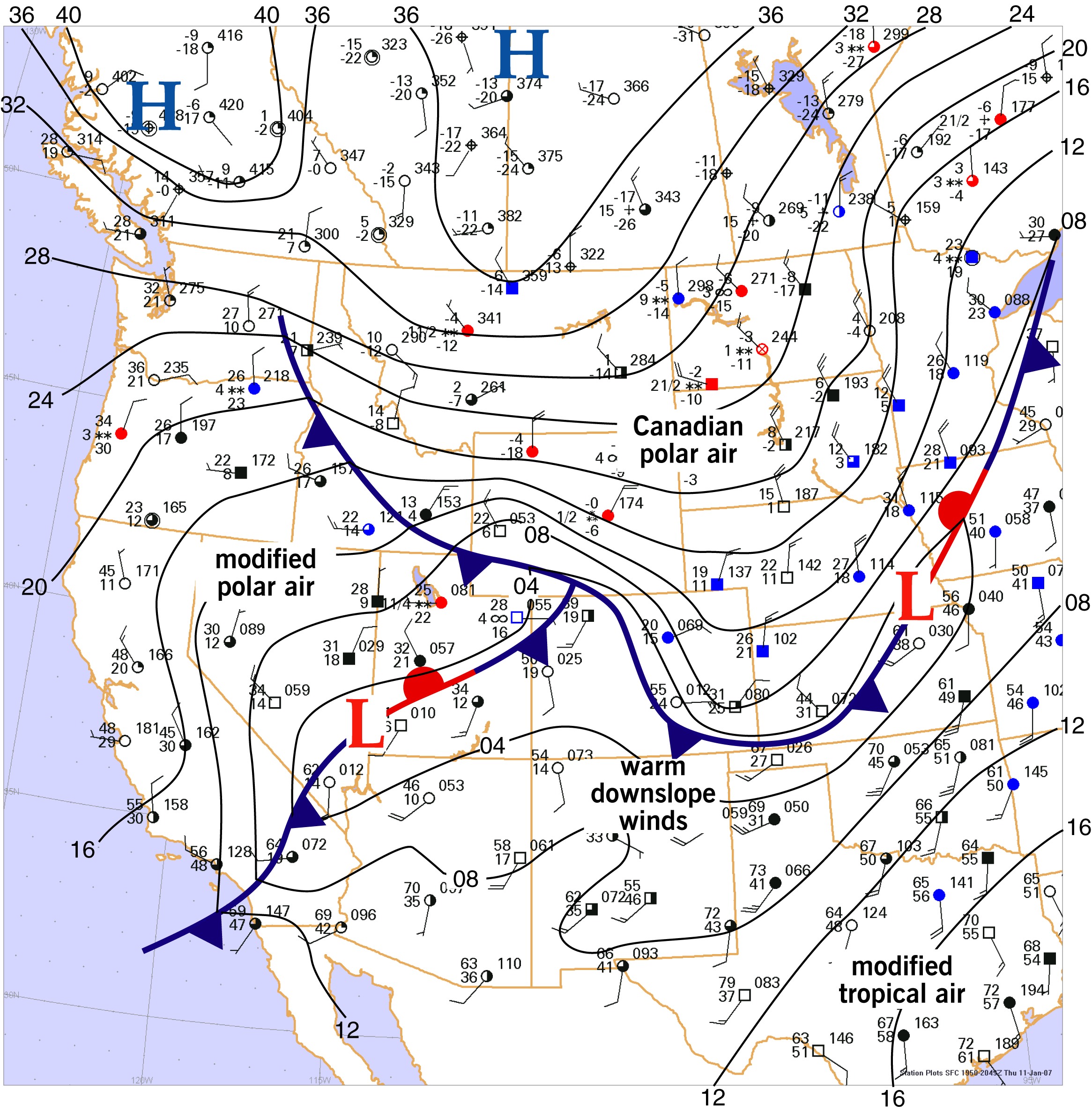
Click to enlarge
©2007 Taylor & Francis
All rights reserved