Page 1 of 1
Surface Analysis/Isobar question
Posted: Sat Jan 07, 2006 7:37 pm
by britbob
I`ve noticed when plotting isobars over eastern Canada, the low pressure centers get messed up with the contours going out straight toward sea instead of being concentric like most lows would be on a surface chart.
I`m downloading metar and buoy data at approx 25 past the hour from Albany. Would this be a problem due to lack of buoy data being imported and DAWS not being able plot properly?
Not sure what I mean?
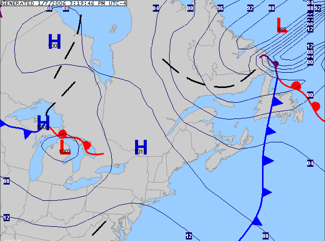
Here`s a chart I plotted about ten minutes ago, covering Atlantic Canada. I`m focusing on the LP just north of Newfoundland. The area of LP is almost rectangular!!!
http://i3.photobucket.com/albums/y61/ma ... urface.gif
Compare that with HPC which show a nice concentric low pressure area
http://photobucket.com/albums/y61/marit ... nt=hpc.gif
Posted: Sat Jan 07, 2006 8:16 pm
by Weasel
Bob,
What I think is happening is only the METARs are being analyzed - at least that is the way it looks from the isobars. You are probably downloading the different data sets at different times (it would probably be best to do the download at six-hourlies; 00z, 06z, 12z, and 18z). If you wait and do the download at say 19:25Z, only the metars will get analyzed because they are the most recent data (the 18z buoys aren't included because they are "old" data).
Another way to correct this is to set the time selection for surface to all instead of 1 hour.
Hope this makes sense:)
Pat
Posted: Sat Jan 07, 2006 9:08 pm
by britbob
Ohhh, so it would be pretty tough plotting an isobar chart that includes coastal areas every hour, because I am likely to miss out on buoy data?
Can you elaborate on this
Another way to correct this is to set the time selection for surface to all instead of 1 hour.
Do mean changing something in the time tokens? or a setting somewhere in DAWS?
Here`s a sample of the script I put together for isobars and frontal depictions. I`m running this every hour, at 20 minutes after.
erase
load,C:\Documents and Settings\Bob\My Documents\DAW-Charts\canada.dmf
download,
http://www.hpc.ncep.noaa.gov/discussion ... \Documents and Settings\Bob\My Documents\DAW-Charts\fronts.dat
download,
http://www.atmos.albany.edu/weather/dat ... \Documents and Settings\Bob\My Documents\DAW-Charts\synop.dat
download,
http://www.atmos.albany.edu/weather/dat ... \Documents and Settings\Bob\My Documents\DAW-Charts\synbuoy.dat
ingest,C:\Documents and Settings\Bob\My Documents\DAW-Charts\fronts.dat
product,wxp,0,fronts
ingest,C:\Documents and Settings\Bob\My Documents\DAW-Charts\syn*.dat
ANALYZE,HILO CONT CINT=4 COLOR=003:003:100 LINE=1 SLPR
import,C:\Documents and Settings\Bob\My Documents\DAW-Charts\overlay.gif
stamp
stamp
export,C:\Documents and Settings\Bob\My Documents\DAW-Charts\product\canada-surface.gif
I guess, I`m getting the metar data, but often I am missing buoy data hence the reason I get good charts on some runs and poor on another?
Posted: Sat Jan 07, 2006 9:18 pm
by Weasel
Just set time selection at the surface to all in the toolbox section/window on the left side of the screen and you can plot them every hour...the buoy data will, however, be older than the metar most of the time as it is uses 3-hour time frames.
Pat
Posted: Sat Jan 07, 2006 9:27 pm
by britbob
Oh, I see what you mean!
Yup, that improves on the buoy coverage setting that to `all`. Much improved apart from the bizarre hi/lo north of Newfoundland.
Here`s an isobars chart from 1625est with surface set to all.
http://i3.photobucket.com/albums/y61/ma ... astern.gif
Ps. Oh damn, I see when you shut down DAWS it doesn`t remember the time selection. It defaults back to 1 hour up restarting the program. Anyways, I`m going to play around a bit.
Posted: Sat Jan 07, 2006 9:33 pm
by Weasel
Set the analysis to barnes w/ 3 smoothing passes. Tskes a lot of the detail out, but that weird looking hi/low thing should vanish. The 6-hourlies should look better much of the time as well.
Pat
Posted: Sat Jan 07, 2006 9:37 pm
by britbob
Much better improvement using Barnes analysis. Can you explain the smoothing process, so I`ll know for future reference?
Thanks Pat

Posted: Sat Jan 07, 2006 9:42 pm
by Weasel
Basically the less you smooth the more closely the isopleths will match the data that is being analyzed by the software. So most of the time you would want to keep this set fairly low to ensure accurate data representation by the isopleth. But that high low thing looked like cr** so that is the quick way to get rid of it...even though the map isn't the most representative after three smoothing passes :)
It would probably be best just to produce the maps every six hours...that way you'll get better buoy coverage and the analysis will nearly always look pretty damn good even with 1 smoothing pass:)
Pat
Posted: Sat Jan 07, 2006 10:01 pm
by britbob
I got ya
I`ll work a schedule out for producing these when the buoy data is updated.
Thanks again.
Posted: Mon Jan 09, 2006 4:26 pm
by Tim Vasquez
HPC's analysis looks better because the domain of the analysis nips a bit of Greenland, and has ship/buoy data offshore. They're probably also using model output as a first-guess field, which is pretty common with centralized products. Also as others have said, selecting Barnes analysis is a good idea when offshore locations are important (this "blurs" the contours better in data-sparse areas), as is getting ship/buoy data. The analysis example had no data to go off of past the Canada coast.
Tim