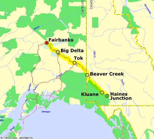
The blackout curtains in the room worked well; in fact when I first
woke up I couldn't tell whether our neighbor was taking a shower or
if it was raining outside. Turns out it was partly sunny and in the 40s.
We grabbed some grocery items at Maudley's General Store for lunch and set
out westward at 11:15 am.
The road led out of beautiful snowcapped mountains and towards Kluane Lake,
the heart of Yukon's gold rush in the 19th century. I became suspicious
of a town on my aeronautical chart marked "Kluane (abandoned)", thinking
I'd seen it in James Michener's novel "Alaska". It wasn't far from the
highway, advertised by a very small sign that said "Silver City", so we
took a dirt road about 3 miles and found it -- long-abandoned ruins of a
once-thriving town. It was still in good condition and a few artifacts
remained in the ruins which could have easily been stolen by souvenir
hunters but weren't (we found out later that disturbing ruins is not
a trivial offense in Canada).
The ghost town was populated by a dozen
Arctic ground squirrels, who were amazingly friendly and were very curious
about what we were doing. They had built an extensive tunnel system that
criscrossed underneath the ghost town. One squirrel trotted up to Shannon
and stood on its hind legs, then resumed nibbling under rocks for grass.
Shannon was able to kneel down and carefully pet it; the squirrel stayed
still and chirped a little bit as she stroked it. I was able to get some
great close-ups of these odd inhabitants with my digital and 35 mm cameras
as they fed, squabbled over territory, and scavenged. We also found a
large rabbit who let us get quite close before hopping away.
As we left, I heard a chirp in the car, and we began thinking that one
of the squirrels had stowed away. We parked the car and began searching
the interior, but did not find anything. Apparently it was a spring
or an engine noise! We got back on the highway and followed the road
around Kluane Lake, stopping for a few minutes to look at the ice-filled
lake and collect some interesting rocks along the gravel beach. We
encountered two major construction zones north of Burwash, which had
collected about 15 waiting RV's and trucks because of construction
delays. After leaving these zones we were once more free and shook
loose of the traffic, and soon had the highway to ourselves again.
Close to Beaver Creek we were tempted to head east to the ghost town
of Snag, which over 50 years ago had recorded the all-time lowest temperature
for North America (-81 deg F), however we could not find a good dirt road
leading the 12 miles to the ruins.
By 5:30 pm we got to the Alaska-Canada border, which had an excellent
setup -- U.S. customs was 1 mile west of the border while Canadian
customs was 20 miles east of the border, so this allowed space for a
great park that was set up right on the border. Here the 20-foot wide
forest clearing that marked the border passed through this spot, and
there was a monument at the border and a park bench that was split
between Alaska and Yukon. We availed ourselves of the great photo
opportunities here. This photo was highlighted by a small thunderstorm
in the background, which is significant because a couple of people in
Oklahoma had told Shannon that by spending late May in Alaska she'd
miss seeing storms -- pure irony!
Clearing U.S. customs took only
30 seconds; the officer was neutrally polite and pointed at the Canon
SLR and HP digital camera in the back seat and asked the bizarre question,
"What are all the cameras for, are you a professional?" Ha! The official
was polite but didn't seem courteous, so apparently the stuff I heard on
Usenet about U.S. customs officials being unpleasant may in fact be true.
Oddly enough the officer didn't ask about fresh fruit; an hour later we
remembered our orange and banana on the back seat floor. At least they
didn't go to waste.
Here in Alaska we gained another hour -- we were now on Alaska Daylight
Time and our clocks were changed from 5:40 pm to 4:40 pm. The next 80
miles of the Alaska highway were very remote and deserted, following a
pretty taiga forest under partly sunny skies. Then we reached civilization
in Tok and fueled up at a Texaco where premium gas was $1.57/gallon.
I did note that Tok had an excellent bike trail leading 12 miles to
Tanacross.
The highway then brushed the foothills of some snowcapped peaks then went
back across some forested lowlands. About 35 miles before Delta Junction
we reached some major construction which took us for 12 miles along a
rough, muddy gravel road.
Finally in Big Delta at 8:45 pm, the
Alaska Highway ended. We stopped for a few photos. Temperatures were
in the 50s but it felt quite warm, probably because of the calm wind and
sunshine. About 10 miles further we saw the Alaska pipeline crossing the
Tanana River on huge suspension towers, protected by barbed-wire fences,
surveillance cameras, and FBI warning signs. Of course, this gave us
another photo opportunity, and after that we pressed on to Fairbanks, less
than 100 miles away.
As we travelled, the sun hid behind a large area of
gray clouds and light showers, which made the road wet as we passed
through Richardson. The road was not in good shape, either, with numerous
broad bumps (due to frost heaves because of partial melting of the
permafrost). Twice we encountered very dangerous ruts in the middle of
the asphalt which were impossible to see until we were right on them.
Sunlight gradually broke out again. At 10 pm we passed the sprawling
Eielson AFB, whose runway paralleled the highway. It was quiet and
a few KC-135 tankers were parked on the ramp.
Finally we arrived
at Fairbanks, which even at 11 pm was bustling with activity with
lots of sunshine. We checked into a more upscale lodge -- the
Captain Bartlett Inn on the southwest side of town.
We are taking a well-deserved rest tomorrow and plan to hang out in
Fairbanks. We will also be looking into a day-trip by jet to Barrow
perhaps for Saturday.
Miles driven today: 518
Expenses:
Gas:
Business ratings (0-4 stars):
Captain Bartlett Inn, Fairbanks AK * * * 1/2
Haines Junction, YT -- packing the car at the Kluane Park
Inn. The camera looks west-southwest at the beautiful St Elias
Mountains, an impenetrable region harboring immense glacier fields.
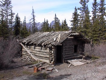
Silver City (ghost town), YT -- An abandoned town just south
of Kluane Lake that was a booming place during the Alaska Gold Rush.
The remains were in great condition and seemed to be well-respected
by visitors.
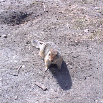
Silver City (ghost town), YT -- an incredibly friendly
arctic ground squirrel stops to see what I'm doing. Even after
learning we have no food, they allowed us to pet them and
occasionally scurried over to see what we were doing.
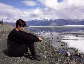
Kluane Lake, YT -- relaxing along the shore of Yukon's
biggest lake. The water was freezing and covered with ice, but
the rocky gravel shore was warm and gave us a chance to take in
the sights.

Burwash Creek, YT -- a summer thunderstorm mushrooms just
30 miles from Snag, Yukon, where the coldest official temperature
in North America was recorded (-80 deg F). Since I am also a
storm chaser, I made it a point to stop and use my 35 mm gear to
get better photos of these storms.
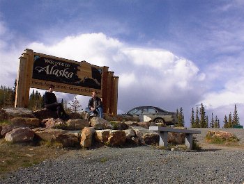
AK/YT border -- we made it to Alaska! This park was built
right on the international border; the camera was in Canada while
everything in front of it was in Alaska. In the background is the
dying storm in the previous photo.
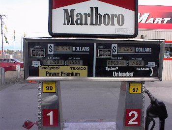
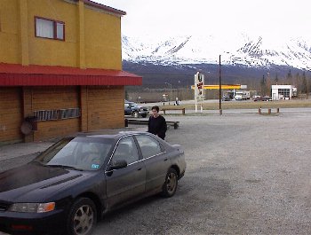
Tok, AK -- it was ironic that one of the biggest oil-producing
states in the U.S. also harbored high gas prices.

Delta Junction, AK -- another milestone; about 200 miles
past the border we reached the end of the Alaska Highway.

Fairbanks, AK -- we stopped at the northernmost Denny's
in the world, but it was crowded, so we left. Here you see the sky
after midnight; the bank sign to the left reads 12:11 (am).