Both of us awoke around 3:15 am ADT to the ship being tossed left and right
as it plowed southward. The ship was creaking and I could hear some
muffled banging below; I couldn't help picturing the vehicles on the
cardeck rolling around and crashing into each other. I checked the GPS
and saw that it had left the sanctuary of the Alaskan straits and was now
on the edge of the Pacific Ocean itself. There was a little bit of gray
light outside, and at the window we could see chaotic 4-foot waves.
I fell back asleep, counting the cycle of the ship's roll (about 8 to 10
seconds). We woke up around 5:15 am ADT with a loud knock on the door
and the purser saying "Prince Rupert in 30 minutes". His voice trailed
off as he did the same thing on other cabin doors. By this time we
were approaching port and the waters were smooth. We slowly got up, got
dressed, packed, and after the ship docked we headed down to the car deck.
As the deck hands signalled us, all 50 of us in our vehicles took our
turn at starting our car and driving off the ship. The lane then led
directly to the Canadian custom border checkpoint, which went very
smoothly (about 30 seconds per vehicle). Then we were out in the streets
of Prince Rupert with a long drive ahead of us. We fueled up briefly
and got a make-do breakfast in the mini mart, then set off out of town.
The mileage sign was formidable, saying "Prince George 797" (kilometers),
after all, Prince Rupert was as far east as Juneau, Alaska and we had a
lot of ground to cover before we were even as far east as the western
United States.
As we drove out of town the alarm clock in my bag went off. It had been set
for 6:15 ADT, and it was only then that we realized we were now on Pacific
time and all our clocks were off (the correct time was 7:15 PDT). The
drive out of town was intensely scenic; we drove along a fjord lined with
lush Pacific trees and vegetation. Unfortunately the highway was 2 lanes
and constantly curving, and the driving was beginning to wear on me after
100 miles of this and only several hours of sleep.
About 200 miles later
we stopped to switch at Moricetown. We went about another 15 minutes
then stopped for lunch at Dairy Queen at Smithers. We then drove through
the next town, Burns Lake (no relation to Smithers and Burns, of nuclear
power plant management infamy on "The Simpsons"). The progress eastward
on Highway 16 was excruciatingly slow to look at on the road map. In
the meantime I continued to study our options for the fastest route to
Oklahoma. One possibility was via Spokane, Salt Lake City, and Albuquerque;
the other was from Jasper to Great Falls to Denver (though the big question
was whether the 150-mile road through Banff National Park, the only option,
would slow us down). We finally decided to take our chances through Banff
and on to Great Falls and Denver. This would also get us out of mountainous
terrain quicker.
Finally, at long last, we made it to Prince George at 3:30 pm, and we
joked a bit about "waking up" and finding it was all a dream and we
were still halfway to Prince George. We navigated through the small city
and pressed on to Jasper down a relatively remote highway that was rather
devoid of traffic (about 1 opposite-lane car every 2 minutes). Just west
of Penny we saw two small black bears along the highway playing in the sun,
and west of Dome Creek we saw a large black bear eating grass and flowers.
He let us watch him eat, mildly interested in our presence but not enough
to come near the car. British Columbia was alive; under the warm
sunshine the trees and grass were a vivid green and we saw a cougar,
elk, some stray cattle, and lots of honeybees. Further on we passed
through an astounding mountain range and right beside Mount Robson, the
highest peak in the Canadian Rockies.
Around 7:30 pm we made it to Jasper, a bustling tourist mecca and apparently
a playground for Alberta. We fueled up and headed down Highway 93 into
Jasper National Park. The gate attendent charged us $10 for the 150 miles
ahead of us, and we drove southeast, past many elk and deer. The road
took us into an incredible mountain range, one of the best striking that
I have ever seen, where slabs of granite seemed to be catacysmically rafted
skyward to heights of well over 12,000 feet like massive icebergs.
Although we had no plans to sightsee, we were astounded by the scenery
and I set up some photo shots in the fading light.
Although there were a lot of campers and RV's in the camping areas, there
was almost no traffic in the park. I am sure this was because it was late
on a weekday night before summer, and if we had tried this on a weekend in
July progress would have been very difficult. The road took us out of
Jasper Park and into Banff Park, which was pretty much the same thing
but a little less impressive (aside from some cavernous mountain ridges).
We reached the end of the road at midnight and got eastbound on the
Trans-Canada Highway. This was a terrible road and I can hardly believe
the Canadians set such a standard for their primary east-west thoroughfare.
Although it was pretty well maintained, the road was very dangerous, poorly
lit, and full of tractor-trailers driving well above the speed limit.
We got off the "freeway" at Canmore and found some great motels. We
settled on the Rundle Mountain Motel, and found an excellent room and
great service with a good price. The room even had a kitchenette with
dishes.
Miles driven today: 897
Business ratings (0-4 stars):
Rundle Mountain Motel, Canmore AB * * * *
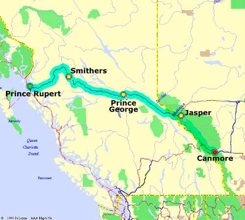
Prince Rupert, BC -- early in the morning, our drive out
of Prince Rupert leads us through lush Pacific forests.
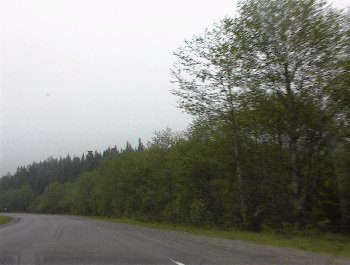
Prince Rupert, BC -- low stratus clouds highlight the
great scenery on our drive eastward.
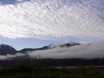
East of Prince George, BC -- late in the afternoon we begin
our long drive towards Jasper, AB on Highway 16 (the Yellowhead
Highway). The scenery was quite beautiful.
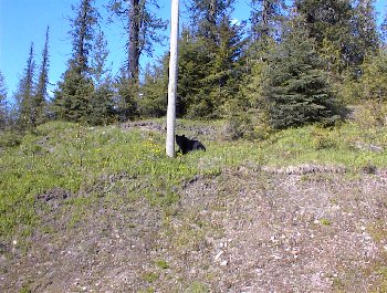
Dome Creek, BC -- another black bear near the highway
grazes on dandelions and grass.
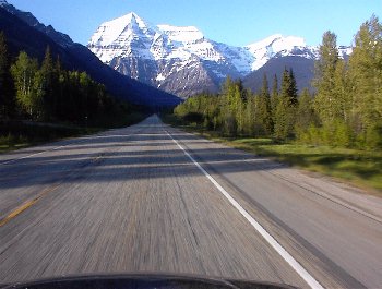
Mt Robson, BC -- approaching the Alberta border, we get
a fantastic view of Mount Robson, the highest point in the Canadian
Rockies at an elevation of 12,972 ft.
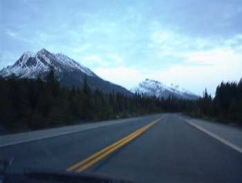
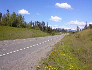
Jasper National Park, AB -- a scenic road winds through
Jasper National Park, with views much more impressive than we
were expecting. This photograph doesn't do it justice, though,
as it was getting dark.