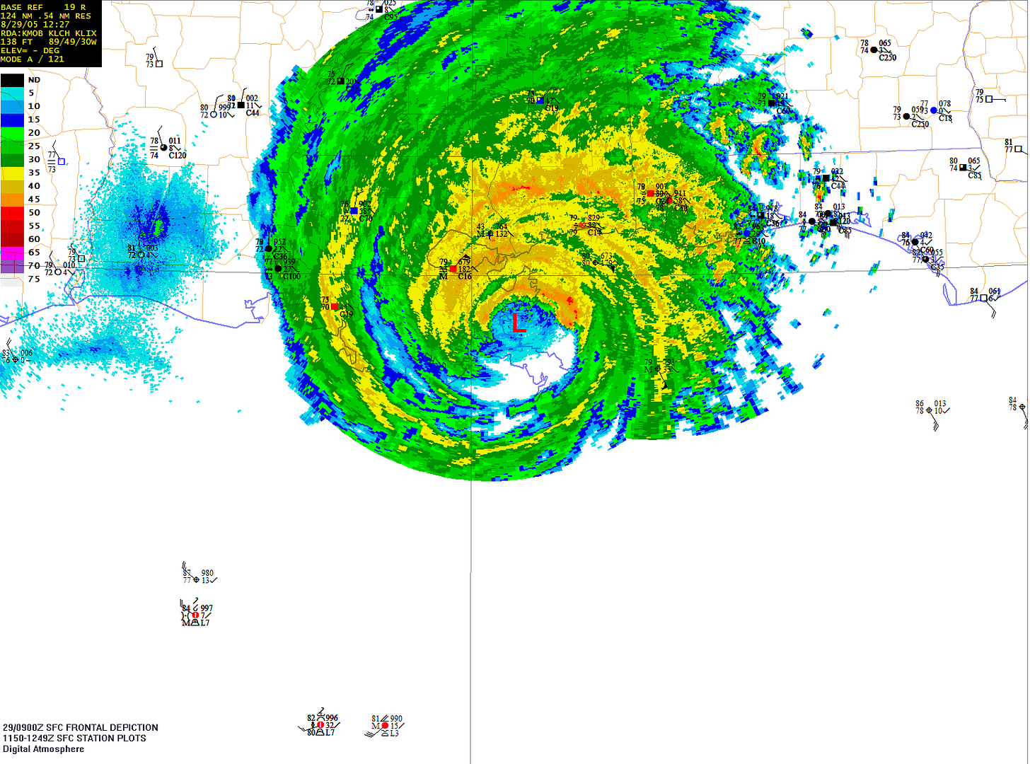
I thought I would post some way cool maps I made using DAWS for Hurricane Katrina. I am in Louisiana but the worst damage we got was a fence blew down during Rita (I was about 70 miles to the right of the eye). No damage at all during Katrina (I was about 100 miles to the left of the eye).
http://i11.photobucket.com/albums/a200/ ... of8-29.png
weatherguy08
http://www.freewebs.com/jays_weather_center[/img]
Neat DAWS Map from Hurricane Katrina
-
weatherguy08
- Member
- Posts: 26
- Joined: Mon Aug 08, 2005 8:58 pm
- Location: Baton Rouge, LA
- Contact:
-
weatherguy08
- Member
- Posts: 26
- Joined: Mon Aug 08, 2005 8:58 pm
- Location: Baton Rouge, LA
- Contact:
See topic Ooops
I made two mistakes. First I didn't make the image post right then I accidently posted a new topic. I am having a bad day!

weatherguy08
weatherguy08
-
weatherguy08
- Member
- Posts: 26
- Joined: Mon Aug 08, 2005 8:58 pm
- Location: Baton Rouge, LA
- Contact:
Re:
Thanks! I used the New Orleans Radar and station plots.
Would you happen to have an image sample of the most detailed kind of map that comes with DAWS Pro?
If you cannot post it, you can email it to me at weatherguy08@hotmail.com.
weatherguy08
http://www.freewebs.com/jays_weather_center
Would you happen to have an image sample of the most detailed kind of map that comes with DAWS Pro?
If you cannot post it, you can email it to me at weatherguy08@hotmail.com.
weatherguy08
http://www.freewebs.com/jays_weather_center
-
Weasel
-
weatherguy08
- Member
- Posts: 26
- Joined: Mon Aug 08, 2005 8:58 pm
- Location: Baton Rouge, LA
- Contact:
joint operations graphic raster maps
The most detailed according to the generate map menu is joint operations graphic raster map (1:250K). The program will not allow me to make one of these and I was wondering how detailed it got. The most detailed I can get is Tactical Pilotage Chart (1:500K).
-
Tim Vasquez
- Administrator
- Posts: 541
- Joined: Sat Nov 22, 2003 10:47 pm
Re:
Hi there -- I haven't been in this forum much lately due to a lot of time pressures, but a user asked me to respond to this thread.weatherguy08 wrote:Would you happen to have an image sample of the most detailed kind of map that comes with DAWS Pro?
The coverage of the JOG raster charts are limited to Texas, E NM, E CO, Kansas, Oklahoma. Here is a sample... if anyone else wants to post a sample, that's fine. Coverage of the 1:250K JOG is not available for New York... it can probably be arranged but at custom programming rates ($$$).

Tim
re:
Wow! Great image...
How did you get radar and obs from Katrina after it passed? Or did you make that when it was happening and just recently post it? I don't know how to access old radar data like that.
Nice obs, too.
How did you get radar and obs from Katrina after it passed? Or did you make that when it was happening and just recently post it? I don't know how to access old radar data like that.
Nice obs, too.
-
Weasel
Re: re:
Nexrad Level III archive from NCDC:LocoAko wrote:I don't know how to access old radar data like that.
http://hurricane.ncdc.noaa.gov/pls/plha ... tname=7000
Pat