Your source for forecasting tools, software, and books since 1993
CUSTOMER COMMENTS

"Thank you for actually penning these books. They are a wonderful review of the concepts without the excessive (but necessary) amount of math behind them. I wish they had been recommended as supplements in both my undergrad and graduate years."

— Josh Tobias, 2017

"I have used Digital Atmosphere for quite sometime and consider it to be one of the most straightforward, comprehensive, and operationally useful programs on my server. I have found it to be invaluable for my day-to-day analyses and forecasting as well as my ongoing research. Tim is also extremely helpful and absolutely indispensable when it comes to locating scripts, the best datasets, and even professional contacts to help make any organization as productive as possible."

Chris Robbins, iWeatherNet

"The quality of your products is second to none."

— C. Brian Batey

"Thanks Tim for your quick response (we like that at FedEx) about our Professional Versions! As we're a 24/7 operation, we're look forward to augmenting our present weather system with Digital Atmosphere."

— Mel Bradley, FedEx Operations

"Wow. Your books are incredibly technical and useful. I consider myself a very amateur weather watcher and feel that I am already ahead of the curve. Thank you."

— Terry W. Taylor

"The NEXRAD support is truly awesome and easy to use - and the other feature just really tops it off. This is about my sixth email tonight - the other five being to other spotters in the area telling them they just have to download Digital Atmosphere and give it a serious going over."

— David Cashion

"I'm really looking forward to the next phase of Digital Atmosphere Workstation. I'm sure it will be as excellent as all your other products."

— Simon Keeling
Weather Consultancy Services, UK

"I run and manage a number of festival type events and Digital Atmosphere is able to produce charts that I can use for normal weather forecasting with a fair degree of accuracy and in particular wind speed and direction that is crucial to many of events."

— Robert Connolly, GI7IVX

"The archive data arrived today. WOW! What an amazing set of data! Thanks again for all the extras that you included as well!"

— Bryan Bollman, IA

"We do run GEMPAK and all the Unidata software also, but your package has numerous advantages, the biggest being Windows."

— Anonymous

"I am very impressed with what you have done. I have already shown several people at work your site. I plan on talking to our MIC [Meteorologist In Charge] soon to see if we can get Digital Atmosphere in the office to complement/supplement AWIPS."

— Ken Simosko, NWS, Pocatello

"This new version is even better than the older version which was awesome! Your programming skills and met knowledge amaze me!"

— Chris Kincaid

Clima-Sim

Weather Graphics is proud to present Clima-Sim, the only "build your own" climate modeling software available for Windows. It is written by Tom Ehrensperger, who holds an MS in physics and authored the WX-SIM weather simulator software. 
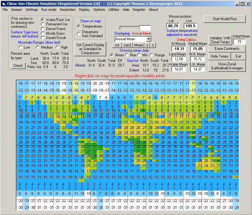
Clima-Sim is a gridpoint model that forecasts changes in climate: that is, the long-term averages of temperature, solar radiation, cloud cover, and albedo. It won't solve the global warming debate, but it will allow you to simulate the global circulation, adjust a plethora of astronomical, physical, and chemistry parameters for the Earth, and see how this plays out on daily, monthly, and annual temperatures for a typical year.

How it works
By solving equations for heat transport around the Earth and between the land, heat, and atmosphere. Once you set up all of the desired option, Clima-Sim "bakes" the simulated atmosphere for 14 months and produces a set of results. This is done in a three-step process, any of which you can optionally skip:
  • Establishing a global seed temperature. Clima-Sim calculates the average annual solar energy at each latitude and prevents oceanic and atmospheric heat transport in order to figure a global set of starting energy parameters for the run.
  • Generating an annual average temperature within each cell. This is done by allowing heat transport (conduction, convection, and mixing) to occur.
  • Producing a series of iterations at which climate values are calculated every 12 hours. By default the run moves forward about 14 months into the future. On a fast iCore it only about 2 minutes to simulate one year.


Experiment!
The ability to control almost all aspects of the atmosphere is where Clima-Sim really shines. This makes it a great program for instructors and students, anyone who wants to tinker with the inner workings of the atmosphere, and even those planning science fiction stories with solid climatological foundations. Here are some of the options available:

  • Customization of continents. Clima-Sim allows you to draw your own continents. Want to try out a Waterworld scenario and see what Kevin Costner might be facing? The "Erase Continents" command does just that. Not only are the continents gone, but you can draw your own world map with the mouse. Try drawing giant continents in the northern hemisphere and small ones in the southern hemisphere and compare the difference. Try drawing Laurasia and Gondwana and run the Cretaceous atmosphere to see what temperatures the dinosaurs may have experienced!
  • Atmospheric chemistry and dynamics. You're able to set the baseline amounts of of carbon dioxide (CO2) and methane (CH4), and you can toggle exchange of heat between land and sea, allow for ocean currents, moderate the interactions ofr dust and trace gases, and much more.
  • Solar dimming. Ultimately, all weather and climate is driven by the sun. The sun's irradiation is not a constant. Within the span of 10 years, it naturally varies by a fraction of a percent, however there's evidence that it has varied by up to 0.2% during the past few millenia. With ClimaSim, you can adjust the solar irradiance through a huge range, anywhere from 85 to 109 percent of normal.
  • Atmospheres of different eras. There are presets for several stages in the Earth's history, ranging from the Permian and Cretaceous atmospheres all the way forward to pre-Industrial and 2011.
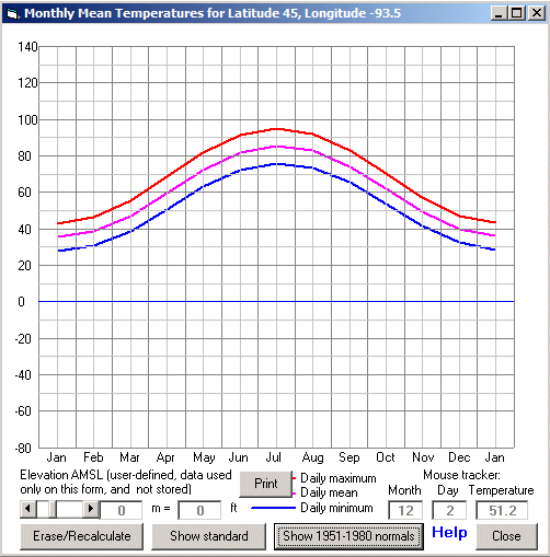
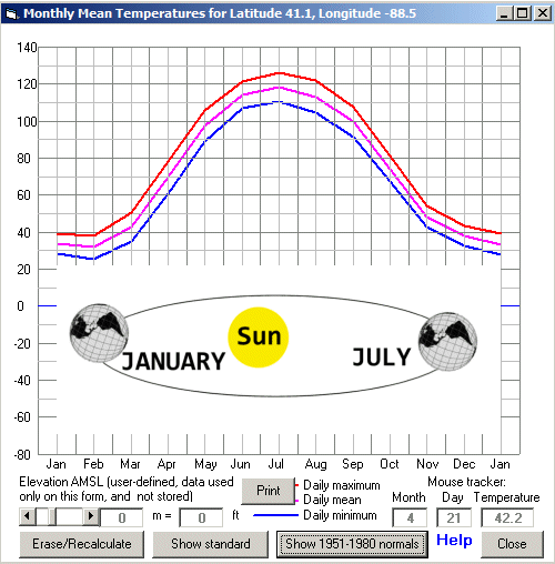
  • Get annual graphs for anywhere on Earth! As you move the mouse across the map, you'll see a readout of latitude and longitude. You can right-click at any point on the earth and get a graph.


Other notes
It must be remembered that heat exchange in the atmosphere and in the oceans is extremely complex and this is one reason why climatology is not a subset of meteorology but forms its own branch of physics. Clima-Sim does not model small-scale processes like cloud convection and synoptic-scale weather systems, nor does it account for large-scale processes like changes in the thermohaline circulation or changes in chemistry from outside sources, such as Arctic and seafloor methane stores. Clima-Sim is intended primarily for educational and experimental use, and its results are provided strictly as-is.

Download
* Demo Mode is provided with the free download:
  » ClimaSim download (0.84 MB)

* Standard Mode (registration required) opens access to many more features, such as the ability to use scenarios other than the pre-defined ones, and also allows drawing of your own continental configurations.

* Professional Mode (registration required) allows additional features, especially the capacity for perpetual (as long as you like) runs, marching through seasons with gradual changes in ice or snow cover possible. Both registered versions allow full customer support at no charge, and also free upgrades for the foreseeable future.


Purchase
STANDARD VERSION

Price:
$49.00
Availability:
In stock

PROFESSIONAL VERSION

Price:
$139.00
Availability:
In stock


This is the main panel for ClimaSim, showing all the major controls that are used to run the simulations.


The terrestrial and solar settings panel allows you to make extensive changes to the chemistry of the atmosphere, the radiation from the sun, and a number of interactions governing heat exchange between air, land, sea, and ice.


You can even change elements outside of the earth's atmosphere. For example, Earth's orbit is not circular but is elliptical, reaching its closest approach to the sun around January 3 and its furthest distance on July 4. This is quite a substantial change, because this elliptical orbit causes irradiation from the sun to vary by 6.9% in a single year. In Clima-Sim, you can change not only the parameters of the Earth's rotation but also the tilt of the Earth's axis. All of these have changed significantly over the past few billion years.


Here is a run showing maximum daily temperatures in July using a Cretaceous ("last of the dinosaurs") atmosphere. Of course due to continental drift the continents were not actually in the configuration shown here, but this can be easily customized before a model run. Given the current layout of landmasses, a Cretaceous atmosphere yields temperatures that are at least a few degrees higher than modern-day July readings in most places. Note that detailed worldwide geography has been overlaid.


Annual temperature graph for Minneapolis, Minnesota using the above Cretaceous atmosphere (again, landmasses were not laid out anything close to what they are now, so this is purely a hypothetical scenario). The red line shows daily maximum temperature, the blue line daily minimum temperature, and the magenta line the daily mean. A low of 28 degrees during January sounds more like Memphis than Minneapolis.


In this example, we have taken the 2010 atmosphere and simply tilted the Earth's axis from 23 to 72 degrees, and plotted the graph of annual temperatures for Chicago, Illinois. In July, the northern hemisphere faces the sun almost head-on, resulting in a tremendous warmup and sending Chicago spiralling up to 125 degrees every day. Needless to say, January obliterates the Antarctic ice sheet, but the massive specific heat of the ocean helps keep temperatures over the Antarctic Ocean in the 90s. Interestingly, shifting the Earth's tilt to a simple zero degrees, removing all seasons except for the effects of perihelion and aphelion, sends worldwide temperatures close to their fall and spring normal temperatures, with temperatures close to the poles having a much colder annual mean as long wave radiation into space becomes the dominant process year-round.