Air France Flight 447:Comments from pilots and other aviation professionals
* Due to time constraints, I am no longer able to update this page.
Please begin using the new
discussion forum
to respond or ask questions.
Hopefully the discussion forum will allow you all to connect with one another
and address topics in better detail.
* Latest e-mails are at the top; oldest at the bottom.
* Last names are typically scrubbed for privacy unless the author requests otherwise.
* Comments and opinions here of course your own and are not necessarily a viewpoint
of myself or Weather Graphics.
FEATURED ITEM
First, thanks for the link to our WWLLN website in your
analysis.
My commment is that your extensive analysis makes no mention
of the possibility of Triggered Lightning. One single,
triggered lightning stroke could well have gone undetected
by WWLLN and not seen by any satellite. Airplanes trigger
lightning all the time, especially when flying through
embedded cumulous that reaches above the -10 isotherm. The
launch commit criteria for launching rockets from the US
bases has a rule, which the Herritage Commission (including
me as a member) recommended, that tries to manage the
risk of triggered lightning.
Any layer cloud more than 4000' thick extending up to the 0
degree, or -10 degree isotherm or above should be avoided.
Most electric charge is separated in the region from -10 to
-20 degrees C, so, if a cloud extends up to this height
there is an excellent chance that the electric fields are
growing to significant amplitudes in that area. Charge separated
microscopically in the -10 to -20 degree C altitude regime
is carried by the updraft to the top of the cloud. Thus we
see large electric fields (up to millions of volts per meter) up
to the top of the updraft, and throughout the anvil.
So, even if no lightning was detected by WWLLN, which sees
only about 10 to 20% of all lightning, and has a lower
threshold around 40 kA peak current, nor was any seen by
TRMM overpasses, which can see only see any given location
under the subtrack for about 2 minutes during an
overflight, it is not proof that no lightning existed.
In fact the lack of lightning may have been part of what
fooled the pilots into venturing into such a severe storm.
Thus, I dont think you can rule out triggered lightning as a
possible contributing influence. With triggered lightning, the
maximum peak current may have been 'garden variety' of 10
to 20 kA, but since that current flowed through the skin of
the craft (if it was struck by triggered lightning) then the
damage to systems may have been larger than you might expect
from natural, near by lightning.
Just a thought.
Sincererly,
Bob
FEATURED ITEM
Throughout the Air France 447 discussion there has been a lot of
emphasis on possible lightning damage to the aircraft, with a tacit
assumption that these big convective systems in the tropics will
necessarily produce lots of lightning. This assumption is clearly
reinforced by the tendency for many meteorologists to refer to all large
convective storms as thunderstorms, whether or not they have any
direct confirmation of lighting being observed or detected.
At the National Center for Atmospheric Research we have examined a
number of turbulence accidents over oceanic areas, including the
tropics. While lightning is frequently reported by pilots, it is usually
described as being off in the distance and by CONUS standards not very
intense. This is reflected in NASAs multi-year satellite lightning
climatology which shows a dramatic difference between lightning activity
over the continents and over the oceans. [figure 1] The storms in the
ITCZ, for example, barely show up at all in terms of lightning
production, although over the Atlantic lightning does becomes
increasingly common as you near the African continent. In this forum,
Kyle-Ms discussion of the difficulties in trying to predict which
oceanic storms might produce lightning is perhaps the discussion that
seems closest to our perspective.
On June 1^st (Julian Day 152), NASAs TRMM (Tropical Rainfall Measuring
Mission) spacecraft passed over the storms implicated in the Air France
crash at about 0220 UTC, just minutes after the last ACARS message from
the plane. One of the instruments on the TRMM satellite is a Lighting
Imaging Sensor (LIS) a near-infrared optical lightning detector that
is capable of detecting lightning strikes within a 600 by 600 km area,
both day and night. [figure 2] While LIS did detect lightning in other
geographical areas (for example, over the southern US and off the east
coast of South Africa), it did not record a single lightning strike as
it passed over the ITCZ. This observation is consistent with the general
lack of significant lightning activity in the long-term NASA climatology
for the area, as well as in agreement with reports from independent,
ground-based, long-range lightning detection systems for this event.
Since the LIS instrument only monitors any given storm for about 80
seconds as it flies overhead it does not rule out the possibility of an
anomalous lightning strike hitting the plane, but certainly suggests
that lightning was not the dominant factor that many seem to assume.
David
NCAR
Attachments:
» Figure 1: NASA_Lightning_Climatology.png
» Figure 2: NASA-LIS_granule.01.2009.152.gif
REPLY: Thank you for the excellent insight and the unique perspective on this incident.
Looking through the literature it does indeed appear that there are studies pointing out the
lack of electrification over these oceanic areas even in the presence of moderate to strong instability.
I will be working this new information into the article in the days ahead.
David replies:
Nice update. The updraft velocity discussion is also looking much
better. Getting the Ed Zipser references into the discussion is a big
plus.
In terms of the lightning, this is a subject area for which some good
pilot reports from the other planes that made it safely cross the ITCZ
on that night would be a great addition to the meteorological discussion
-- and to our understanding of the conditions that they all faced, and
apparently face regularly on this route.
FEATURED ITEM
I work at the NASA CloudSat Data Processing Center at the Cooperative Institute for Research in the Atmosphere (CIRA) located at Colorado State University. First of all I want to compliment you on an outstanding meteorological analysis surrounding the tragic loss of Air France flight 447. I also want to let you know that about one hour and forty-five minutes after the flight?s last automated message, CloudSat, a NASA satellite mission that carries a nadir-looking 94 GHz cloud radar passed over the same MCS just to the west of your estimated flight track. I put together a Powerpoint slide (attached) in which I overlaid a MODIS infrared image containing the CloudSat flight track onto the GOES 10 image I obtained from your web site. The MODIS image location is a ?best guess? based on cloud morphology and an estimate of where the CloudSat track should be but I think it?s pretty close.
I also included an image of the radar data obtained along CloudSat?s track and your sketch of what the radar image along the aircraft?s flight path might have looked like.
As a result of the time and location difference the utility of the radar data is limited beyond the sake of interest, maybe to show an example of the type of environment that the aircraft was flying through, and definitely to show that your artistic skills are very good! The bright line below cloud level is the reflection of the radar off the ocean surface. In areas of heavy precipitation the signal is attenuated as indicated by the disappearance of the surface and anomalous returns extending below the surface caused by multiple scattering of the radar beam. Obviously the heaviest precipitation and strongest updrafts are on the northern side of the storm evidenced by the radar signature at the surface and strong in-cloud echoes extending to or through the tropopause. Another feature of interest is the bright band just below the melting level in the image.
The CloudSat images are available from the Data Processing Center?s website at
http://cloudsat.cira.colostate.edu/dpcstatusQL.php
(this is our Quicklook Images Archive). Just click granule 16452 and then click on the blue segment 31 to bring up the full resolution radar and MODIS images. I hope this is interesting to you!
Thanks again for your analysis!
Phil Partain
CloudSat DPC Lead Programmer
http://cloudsat.cira.colostate.edu
REPLY: This is amazing stuff. I have posted this image on the main article
page and sent you a separate e-mail. We all thank you!
Phil adds:
The quicklook images on our website are produced from the raw, uncalibrated data and the only
vertical scale is that the radar window (the gray part of the image) is 30 km. So a rough
estimate of the height of the storm can be made by measuring from the surface to its top.
I get a number like 16.8 km or ~55,100 ft. Of course that is the top of the storm as
seen by a 94 GHz radar. The radar misses smaller cloud particles that most likely would
put the actual top of the storm a little higher. Actually, now that I compare that with
your estimate from the IR signature it is in good agreement, though it was a different
part of the storm 1.75 hours earlier.
FEATURED ITEM
Hi Tim,
Our satellite meteorology section is collaborating with NCAR on
convective diagnosis for aviation safety issues and have produced
several products that may assist your excellent reconstruction efforts.
We realize you have reviewed both single GEO images and cloud top height
products as well as animations, but please let us know if these items
shed additional light on the meteorological conditions.
Note we have both GOES-12 and GOES-10 digital data available. The CTOP
loop (animated gif file) is a cloud top product that incorporates the
model temperature profiles to extract altitudes, then an adjustment is
done for standard atmosphere to put into the appropriate aviation
reference frame.
If you decide to post any of the material, please acknowledge both NCAR
(Cathy Kessinger is the PI and cc'd here) and the Naval Research
Laboratory (Rich Bankert is the PI). We welcome comments on these
products and wish the best for conclusively determining the cause of
this unfortunate tragedy.
Regards,
Jeff & Rich
REPLY: Many thanks for the images -- I have posted them on the main analysis page and will
be blending them in.
Their website can be visited at
http://www.nrlmry.navy.mil/sat_products.html .
FEATURED ITEM
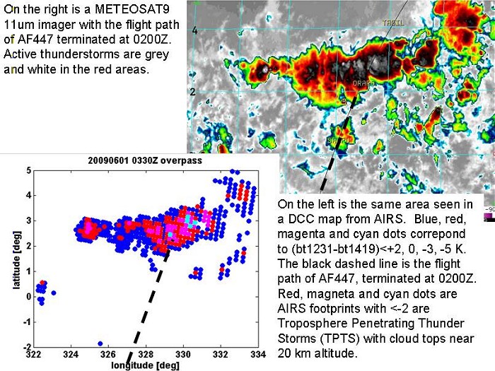
Excellent article on the AF447 tragedy.
Attached are some AIRS data from the 1:30 AM (local time) overpass on the
same scale as your rendition of the METEOSAT 11um imager. We show
Troposphere Penetrating Thunder Storms (TPTS) in red, magenta and cyan.
The blue dots are thunderstorms at about 15 km altifude. The wildest ones
are cyan, and peak well above 20 km. A TPST is defines as any object where
the difference between the 1231 cm-1 window channel and the very strong
water line at 1419 cm-1 is less than zero. We pull these objects from the
data routinely to do an off-line cluster analysis. This was a cluster of
essentially contiguous TPTS, extending about 150 km along and about 300 km
across the path of AF447.
If enough people with good data from the crash area could come together in
a web meeting and exchange data and ideas, something good may come out of
this tragedy.
George Aumann
AIRS Project Scientist
http://airs.jpl.nasa.gov/
REPLY: Thank you very much for sending along the excellent imagery. I have
posted it in the main article and will blend it into the analysis within the
next few days.
Mon, Jun 22 2009 14:00:02 -0600
Tim,
I'm sure you are getting plenty of feedback on your excellent writeup of the AF447 accident environment. I'm an aircraft icing specialist and wanted to point out a factor that hasn't been discussed much...high ice crystal concentrations. I've seen flight test data from power rollbacks due to flight in high ice crystal environments and there a number of engine failure case studies in the literature.
In our case, the crystals collected within heated, aspirated Ram Air Temperature sensors, forming a 0C slush that makes the engine think it is flying in warmer air than it is. Other manufacturers have had flameouts possibly caused by ice buildup in the engine compressor although the exact mechanism for the flameouts is unknown.
The air temp below -40C certainly points towards ice crystals, and other flameout issues have occurred in similar circumstances (mostly over SE Asia) while flying over active MCS's due to the very high crystal concentration over the updraft regions.
Cris ---------------
Wed, 17 Jun 2009 14:01:28 +1200
After reviewing my original comments to you regarding the track of AF447, I
have come to similar conclusions as you regarding the position of the
aircraft at 0214z.
Last week I created a webpage with my findings at:-
http://countjustonce.com/af447/
which includes a fairly large chart with the track from 0200z to TASIL and
estimated positions in 2 min intervals. It is based on the Flight Plan
FL350 at 0.80 Mach, with a comment in the final paragraph on what the
outcome represents if the actual enroute GS was 453 Knots as widely
reported.
The page is hopefully designed so that "lay persons" will be able to
understand what is described.
If you get a chance (and you're agreeable), would you include the above link
in your Analysis page where you mention my name.
Barry C--------------
Tue, 16 Jun 2009 20:40:07 -0500
I revised my email to you, because I have found additonal information
that is relevant to AF flight 447.
What I find most interesting about your weather analysis, is the
turbulence flight 447 ran into during the time period between 0151Z to
0210Z. Although flying into the main cluster of the storm, (from 0210Z
to 0214Z), finished off Flight 447, I think the turbulence leading up
to the 0210Z ACARS transmissions are more important. Further critical
analysis of the windshears and updrafts within the area just south of
the main cluster is needed.
You mentioned earlier that it appeared AF447 crossed through three key
thunderstorm clusters: a small one around 0151Z, a new rapidly growing
one at about 0159Z, and finally a large multicell convective system
(MCS) around 0205-0216Z. At 0200Z- according to AF aircraft
transmission, entered a "thunderous zone with strong turbulence."
At 0210Z, one of the first ACARS transmission involved the rudder
limiter. One Air France official, said the error message pertaining to
the rudder limiter did not indicate it malfunctioned, but rather that
it had locked itself in place because of conflicting speed readings.
But, other experts theorized that perhaps that may have happened based
on the relatively limited damage to the stabiliser. If the rudder were
to move too far while travelling fast, it could shear off and take the
vertical stabiliser with it. (Brazilian recovery photos do show these
two pieces still joined together, when the vertical stabilizer and
rudder were recovered at sea). The recovery of these items intact
would lend much support that the turbulent air may have produced a
force load of 0.8G or better striking the vertical stabilizer
broadside on the Airbus 330 and sheered it off!!! As mentioned before,
that will happen if the plane is banking to one side in the storm and
is hit suddenly by a severe updraft.
I have seen an old military film once of a B-52, with it's vertical
stabilizer tail sheered off, and made it back safely to base. Taking
an excerpt from "Who needs a Stinkin" Tail"? (see:
http://www.imperialrcclub.com/pdf/Misc%20Articles/Tailless%20B52..pdf.
It also has a picture of the damage plane.) The first part of the
article said:
"January 10, 1964, started out as a typical day for the flight test group at
Boeing's Wichita plant. Pilot Chuck Fisher took off in a B-52H with a three-
man Boeing crew, flying a low-level profile to obtain structural data.
Over Colorado, cruising 500 feet above the mountainous terrain, the B-
52 encountered some turbulence. Fisher climbed to 14,300 feet looking for
smoother air. At this point the typical day ended. The bomber flew into clear-
air turbulence. It felt as if the plane had been placed in a giant high-
speed elevator, shoved up and down, and hit by a heavy blow on its right side".
Fortunately for them, they were an experienced test crew, and did not
have a plane loaded with 220+ terrorized passengers. But, it does give
some similar clues and perspectives as to what AF flight 447 may have
been experiencing starting about 0159Z. Although AF Flight 447 had a
far superior autopilot than what that old B-52 had, I am not so sure
the A330 was ever engineered to match the ruggedness of the old B-52's
airframe. Also, Pilot Arthur Doucette who has studied aviation
accidents, particularly the Flight 587 accident that happened a few
years back, said this:
"Note that the B52's design is quite different and that a good size
piece of the VS remained (enough to provide significant lateral
stability). The B52 also had the wing mounted much further forward,
hence the whole fuselage acted as a stabilizing force (the feathered
arrow effect). The A300 is just barely stable without the fin, with
the wing mounted further aft the pitching forces ahead of the center
of rotation are about the same as those behind the center of rotation.
If the A300 fin departed while any amount of rotation was going on,
the forces would have quickly spun the aircraft in the previously
described "flat spin".
Of course, since the A330 is not much difference from the A300
airframe, his analysis would apply to the AF Flight 447 too. The
pilots would have had no control over the plane once the autopilot
kicked off, as they entered the main portion of the storm without a
vertical stabilizer.
So, getting into strong storm updrafts and crosswinds in a commerical
plane might be more dangerous than previously assumed. (Afterall,
industrial tests data is often assumed for most planes, based on
interpolations from some previously designed test plane under
controlled conditions, and not from actual testing of each and every
single plane produced).
It should also warrant more refined developments in remote sensing
techniques to reveal these sort of turbulent atmospheric conditions,
so commerical aircraft can avoid
them. (Aircraft doppler radar cannot always be relied upon to see
updrafts and crosswinds that have have very little moisture and/or ice
associated in them). I think it is necessary to continue your analysis
of the photos you do have of this storm system, to see if we could
possibly squeeze more information out about what the updrafts and wind
sheer conditions were like over the course of AF flight 447 track,
from time 0151 to time 0210Z. Maybe a several different false color
composites might reveal more?
Respectfully,
Don H-----------
(Retired Air Force Physical Scientist)
Mon, 15 Jun 2009 13:41:41 -0700
Thats a great work You are doing and expertly presented which I
accidentallly came across while looking for weather-Pix for the
AF447-Incident.
I am now ret.GP from Germany, living with my wife on her Home-Island
of Bali and we are expecting our Son's Family (4 God-childr) with
their friends to come visit us.
That's why the long-range Night-flight / Nightmare for the AF447 is so
touching to us,
It may happen again and again soon, if the real underlying cause is
not put up for open discussion. And permanent notifications are passed
on to airline pilots.
And -to my mind- essential points have yet been kept under the table.
As a Science and Weather & Health-interested technical Fan with
Biological & Organic Radio-Isotope-Biochemistry Hobby I have been
following the Climate Discussions and the GW-Processes discussed with
scepticism.
That is, because I see the Hydro-Isotopic influences only marginally
being touched.
1.) Forceful Lightning in the remarkably strong "Electric Hurricanes"(1),
2.) Fact of Increased Hurricanes Cat.5 dissipating more Energy now
than before the time of the last 20 years' esp.in the Pacific, as well
also in North-Atlantic (2)
3.) the Ice-core results (3) as well as the possibilities for
"Generating Cold Surge Vortex" and controlling them by their
Hydro-markers' content (presented at CEOPS-GEWEX-Meeting 5-8.Sept.2007
Bali (4)
made me raise these points in some discussions.
The Discussions about "Severe Space-Weather Events"(5) let me look
into the mentioned "possible linkages from ISS'-Orbit's level in
Ionosphere's Vacuum down into Strato-Tropospheres' region" for
Space-weather-like effects characterized as
"Stratospheric Ozone-Intrusions"(in the named pdf of 5).
Then finding ESA's own descriptions about the new ESA-ATV Module (6)
made me think of the Consequences for some phenomena observed here in
the Region.
Indonesias Islands are all in the Monsoon area. Traditionally there
are no trans-equatorial natural winds blowing, there were instead the
Calmen- belt and the Turbulences experienced on my frequent
air-flights to & fro Indonesia "in the Straits"
But the new phenomena: are weekly or 2x/week news in TV and Newspapers
frequent parallel stripes of heavy rain reported,
like wise parallel Stripes of landslides, many in stripes over the Equator
in some regions stripes of torrential rain with Inundations
recurrently in 3 - 6 d.
Torrents falling in nightly stripes filling fresh-water lakes to
the overflow
in one recent case (the day before Shuttle landed End of May 09)(6)
The sudden overflow broke the dam at the side causing a Muddy Tsunami
washing down a village leaving 280 sleepers missing
One early Morning Hercules Troop-Transporter coming from Jakarta fell
directly from heaven before landing near Surabaya into fogs
after a stormy
night, the big wings were reported as collapsing above and
the plane went
wobbling right down to earth breaking there on arrival, 118
killed (7)
Another reported case of heavy rainfall induced over middle east of China led to
suddenly filling up a new built Water reservoir triggering an
Earthquake by the sudden increase of weight killing 70-100 000 people
in 18. May 2008.
These Events like frequent Strikes from Heaven are very seldom reported from US.
The Peri- & Apogee Observations (which I had seen and partly noted)
all show ISS flies permanently higher over the US than over other
continents..
This is the background of my letter which I sent to the AF-Archives
for promotion to the French President and to Youtube to notify
Pres.B.Obama.
If I had known your address before I might have discussed it with you first.
So, I wonder whether you may have taken these Facts into
Consideration and whether the wings of the AF447 might have collapsed
above the plane causing the immediate descent ?
So please, Mr Tim Vasquez, read my letter and kindly let me know, what
you think of the argumentation..
Dr.med.Klaus J.S---------
Attachment: My Letter to the AF-Archives of 13.06.09
Literature:
The points for your Lit.Reference mentioned above were derived from :
1. NASA.gov on Emily, Katrina & Humberto as examples of strong
'electric' Hurric.
2 . Hurricanes in Hazard& Risk Science Review 2006 , p.5-11,
pdf fr.:www.benfieldhrc.org
3. http://www.lowtem.hokudai.ac.jp/english/topics/H19-2-2.png
4 http://hydro.iis.u-tokyo.ac.jp/GAME-T/GAIN-T/index.html
5 free pdf at: http://www.nap.edu/catalog/12507.html
6. Reservoir of Situ Gintung near Jakarta on 29.5.2009
7. Daily Mirror 21.05.09 . accid. 20.05.09 near Maketan(East Java)
Actual cause unknown, survivors notes: felt like loud
explosions, wobbling
to left and right, one wing came off before it went down and
hit the ground
Sun, 14 Jun 2009 18:05:13 -0500
Tim- Great analysis on AF447! My question relates to everyday thunderstorm flying in an airline environment in the domestic US. Specifically, during this time of year we see airmass type thunderstorms throughout the western plains and the rockies. I have flown with some guys that seem to feel that it is generally ok to get "close" to these types of cells as opposed to a squall line situation.
I fly the 757 out of MSP and because that aircraft has excellent performance (certificated to 42,000 ft.) many pilots seem to think they can climb right over many of these cells. I did attempt to fly over one cell in Florida at 42,000 feet one February day - I was successful with a smooth ride, but that attempt then left me feeling some degree of anxiety about trying that again. We were right at the limits of the airplane with no room for error. Better to go around if at all possible, in my opinion.
Brent ----
Northwest Airlines, Inc.
Sun, 14 Jun 2009 12:16:17 +0100
I have read through your weather analysis which I believe to be excellent, however, it also would seem to assume ?normal? situations which, perhaps, was not the case given the outcome. Something abnormal happened and seems to have been associated with the weather at the time, as there is little else to blame.
The question I would ask be considered is, what might have happened that would normally not be expected to happen, in order to bring about the error messages that were transmitted?
The possibility that I, as a transport pilot, cannot put out of my mind is unexpected super cooled water, and a large amount at that, which should not normally be found at the altitude.
It is not good enough to say that it would not normally occur, but could it, under extreme conditions?
The interesting thing is that if it did occur you could start to tick boxes. Ice could have formed quickly enough to cause speed error readings. Given sufficient density of super cooled water you could also question engine performance and, perhaps, the possibility of flameout which would certainly put a dent in the cabin pressurization.
I am not sure that there is another explanation, far fetched though it may be, that might fit the known difficulties.
I just wonder if the data you have might be adapted to agree? Not that it changes anything.
Regards
Michael L---------
Sun, 14 Jun 2009 10:50:24 +1200
I crewed heavy jets across the Pacific from north to south for 38 years commencing in 1965, crossing the ITCZ on countless occasions.I had three very disturbing icing encounters during those years, on three different models of aircraft. All three occurred at FL370, all in the ITCZ, all involved ice accumulation on parts of the aircraft where the manufacturer said it would not/could not occur and accordingly no de-icing/anti-icing system was in place in those critical areas. In each incident the aircraft and contents were put in serious harm's way. In brief, ice became impacted in engine air/oil heat exchangers in one instance, Air-conditioning pack ram-air inlets chocked with ice in another instance, and on a 1980's 'Classic', severe icing including run-back and refreeze on the wings. In this particular case there were other extenuating circumstances which placed the aircraft in a perilous situation, (TAT probe icing, defective radar and other technical issues).
Why I asked over the years did aircraft designed and built by the world' finest and most reputable aircraft makers not have protection in these critical areas, and why did highly experienced Pacific flyers be caught in these unusual (but rare) circumstances.
Four years after I retired this little gem appeared in Aviation Week & Space Technology dated September 13 2004.
The subject of the article dealt with the new weather radar systems being developed for the 21st centurys newest airliners yet to take to the skies, the Airbus A-380, Boeings 787 & others to follow.
The article titled Storm Finder. New weather radars should help airline pilots avoid turbulence and passenger injuries.
In the process of developing and testing the new WXR-2100, Rockwell Collins engineers found significant differences in weather in various regions of the world. To the naked eye, a thunderstorm in the U.S. Midwest might look the same as one brewing in the South Pacific, but the two storms are likely to have a completely different makeup in terms of radar reflectivity. For example, storm cells over the ocean have extremely low reflectivity, unlike the Midwestern ones. Engineers discovered that oceanic weather is, on average, 200 times less reflective than storms of similar height over land masses
Thomas S----
Sat, 13 Jun 2009 16:42:01 -0500
A very quick huzzah from a retired international 747 captain and weather junkie!
Captain Jim B---------
Minnesota
NWA retired
Fri, 12 Jun 2009 21:33:44 -0700 (PDT)
Thank you for all this insight on weather patterns. I wish to add my worst weather story even though I am not sure if it relates to tropical weather systems. I am an Airbus 320 pilot for a domestic US Airline.
On November 31st, 2007, we took off from San Diego, CA (KSAN) enroute to the east coast of the USA. About 75 miles east of San Diego at an altitude of 21,000 feet we encountered severe turbulance. It was clear with no weather present. It was by far the worst turbulance I had encountered in my 12 years of flying. It lasted for about 10 minutes. I could not believe how severe this turbulance was. At one point I honestly did not think the aircraft could withstand such turbulance. We tried flying out of it but we were at the mercy of mother nature. The aircraft was not fully controllable at times. All the pilots on the next radio frequency were reporting it at all altitudes.
What made me think of that incident when reading your discussions was the fact that after we arrived at our destination, I pulled the Surface Analysis Chart and the Jet Stream Chart to try and understand what caused this severe turbulance. I noticed the Jet Stream that night had dipped sharply from North (Washington State) all the way down to Mexico and then took a sharp turn back North towards California and Arizona. I suspected that Jet Stream was carrying very warm tropical air into the wintery cold US air, and that the area of the clash (Major temperature difference I suspect) caused the turbulance. I am not certain what the outside air temperature at the time was, or how much it had changed.
Again, I am not sure if this has anything to do with what you are talking about here. But hope this helps further understand what happened to the A330.
Samer A----
Fri, 12 Jun 2009 09:09:47 -0700 (PDT)
Great article by the way.
My main point is in reference to Fig 6 on your analysis. I am by no means an=
expert, only flying airbus and over the ITCZ for last 2 years. However=
reading your article and seeing the pictures, straight away I thought I=
would have wanted to go slightly left off track about 100nm north of INTOL=
(shortest way around the cell). Once past this initial build up, this=
probably would have given a weather radar picture of a gap just left of=
that very strong updraft (depending on what range was set on the display=
and the stage of the updrafts life, it may have depicted a total lack of=
weather in that gap!) which would have looked inviting compared to the rest=
of the weather at the time.
If this assumption is made and the aircraft flew right into that updraft or=
even clipped it, would this make it easier to understand the outcome of the=
flight.
The reason I say this is because it is very common, especially when on HF,=
to divert slightly around weather without a clearance. Your analysis is=
fantastic but is assuming the aircraft was on its track, which over the=
ITCZ is rare. On Fig 5, you even see the very strong updraft not existing=
in the first frame or so. This may have been construed as a gap between the=
storms which would of course be the obvious route to take.
But as we all see, sometimes in the dark its not the whole picture.
As said earlier, this was just one of the first things I thought and I have=
not had much of a chance to read the other posts to see what others have=
thought, so sorry if I have doubled something up.
Keep up the good work.
Scott
Fri, 12 Jun 2009 11:51:33 -0400
Myself and my dear corresponding friend agree that the 447 broke up mid-flight as a result of "washing machine" turbulence.
The only however, is, that, the GPS-tracking beacon quit a few seconds before the maintenance transmitter quit.
I was under the ass-umption that, like, the black-boxes, the GPS-tracker and, the maintenance transmitter had their own
back-up batteries so that they would continue for a short time so that a radar "fix" could be made.
This didn't happen.
The maintenance transmitter lasted long enough to report that the plane was in a near 90-degree descent.
The GPS-beacon died before that report.
Does that mean, that the mid-air breakup was so complete that the back-up batteries for both were damaged beyond hope ?
Just curious.
I'm afraid much of the jargon used on this website is well beyond my fossilized mind.
Thanks for your consideration of this note.
Sincerely, with goooooood wishes.
Gord
Thu, 11 Jun 2009 11:37:35 -0700 (PDT)
BEA posted a reconstructed flight path:
http://www.bea.aero/anglaise/actualite/af447/reconstitued.flight.path.jpg
I have reverse engineered a couple of the locations using Google Earth:
0130Z
157.1 nm, 471 kts
0150Z
77.4 nm, 464 kts
0200Z
75.7 nm 454 kts
0210Z
You could use this to revise your extrapolated positions. I could never
find the source of the 0214Z position that was in Aviation Herald - I now
think it was wrong all along. The 0210Z in the BEA flight plan is a very
close match to the SAR map final location I posted in your forum (Crash
location). So the SAR teams have been using the BEA 0210Z location all
along.
It looks to me like they flew straight into this storm.
I'm traveling this weekend and won't be able to reconstruct more locations
for a while:
0130Z - 1 39.500'S 32 59.000'W
0150Z - 0 39.943'N 31 45.392'W
0200Z - 1 48.654'N 31 9.109'W
0210Z - 2 57.192'N 30 35.309'W
Thanks,
-Rick
Thu, 11 Jun 2009 11:15:07 -0400
Very interesting reading your comments. As soon as I read your significant warming at altitude theory, I immediately remembered an event similar that happened to me a few years ago. I had to go back through my log books to find the exact date.
On june 16, 2004 I was on a leg from KFLL to EIKY in a G-IVSP at FL430, .82M, ISA -4.
It was a day time crossing. We were in clear skies with no convective activity around.
Our route of flight was a great circle route running to the south of Greenland and Iceland. When we were about halfway between them, at about (estimate) 1600z in the span of no more than 10 or 15 minutes, we found ourselves at ISA +16. This totally confused the FMS and it commanded a speed of .69M and the auto throttles started to retard. I disconnected them and pushed the power up to max TGT. If it wasn't for the powerful Rolls Royce Tay engines on the G-IV, we would have had to descend but we were able to maintain our altitude at .78M.
30 minutes later we were back at ISA -4 and I reengaged the auto throttles and we proceeded on as if nothing had happened.
Mike S----------
Thu, 11 Jun 2009 18:04:40 +0000
Gentlemen-what a beautiful source and info exchange. Very very accurate.
As a former airline pilot, I want to offer these ideas into your realm of ideas.
HAARP has been fully operational since 1993, and now with at least 133 sites around the world, plus SCALAR from 5 countries, we have entered into are indeed are inside the portal of totally controlled weather, including Hurricane, TRW, Tornado, and Earthquake induction.
The whole concept of weather control revolves around "atmospheric heating", which involves the ionisphere. The HAARP facility at Gakona, Alaska, with its ever-present occult signature-is at the capability of 3 Terawatts(3 Trillion) watts.
Having studied this since 1995, I observed ongoing "pockets" of incredibly warmed air. Usually-but not always anounced with turbulance(NOT Jetstream) induced turbulance.
Most of the folks I flew with laughed at the idea of controlled weather. That is because the electronic toys on are aircraft condition us to "think" inside the box.
Not many are even willing to talk about this. Certainly, ALPA would never discuss this.
In any event, the Jetstream has been controlled since the seventies with SCALAR.
Now it is ALL controlled. I have the documented LAT/Long cordinates of most of these facilities. So do others.
I have NO doubt ongoing SCALAR ops are ongoing in the ITCZ, as it makes a great "natural" area to perfect the SCALAR ops program.
One only needs to visit the Arrow DC-8 event in Gander back in the eighties. It is real.
Thank you for a wonderful site. As for me, I was taken out with a brain tumor, but I completed 16370 hours, from Regional turboprops to the B-727.
Sincerely, al m---------
Wed, 10 Jun 2009 20:37:41 -0700
Wow - that's all I can think of to describe your wx analysis of AF 447
crash. I'm still trying to get my head around the terms and concepts of
your impressive work. It's also amazing how the synergy of the web has led
to others chiming in with their piece of the puzzle, making the whole piece
that much more comprehensive.
I've taken the liberty of forwarding some of my research findings on jet
upset to you in that spirit of contribution and also to possibly help inform
your analysis by reading almost a blow by blow of what NW 705 went through,
and UA 746, which recovered from similar circumstances 5 months later.
The first attachment is noted Australian aircrash expert Macarthur Job's
analysis of NW 705 crash. The second is book refs. and dedication page for
Job's work (read the dedication page).
By separate email are two attachments from R. Sterling's book - Loud and
Clear - which, though old, also talk about NW 705 and UA 746. I've more,
including the CAB report, if you're interested. Let me know.
My interest in jet upset incidents is personal. My father, Jack, was a
passenger on NW 705.
Thanks for your time. Keep up the excellent work.
Jim H------
REPLY: Thank you for sending these (especially since my Macarthur Job book is in storage),
though I regret I cannot post them on the website for other visitors due to copyright considerations.
Wed, 10 Jun 2009 22:40:44 -0300
I am a retired test pilot for BAe146 aircraft who conducted flights in and around Cbs to research engine icing problems. I was also involved in several investigations into engine ?rollback? incidents associated with icing in the vicinity of Cbs.
I assume that you are aware of Walter Strapp?s work:-
http://icingalliance.org/meetings/ASME_2007/documents/AIRA_ASME_2007_Atmospheric_Characterization.pdf
http://icingalliance.org/collaborations/documents/Strapp_Engine_Icing_Project_2007.pdf
http://airs-icing.org/AIRS_II/AIAAReno2006/AIAA-2006-206-739.pdf
My memory fails me, but he most likely participated in the BAE/Honeywell tests in Panama (1997 ? ? my flights), together with a scientist from UMIST (Manchester University UK); these tests preceded the rollback flights in the US, which Strapp reports.
The initial tests established that the ?rollback? incident crews were not in the tops of Cbs, and although I did not experience engine problems, the likely atmospheric conditions were in the Cb outflow and surrounding areas and not necessarily in CBs.
Perhaps the following points are some of the significant ?warming? issues from my experience and particularly from the incident investigations:-
· TAT anomalies were associated with Cbs, the anomalies were due to probe freezing.
· TAT probe freezing was linked with ice/water content (Walter Strapp)
· TAT probes were shown to suffer from ice crystal freezing (Rosemount tests / video)
· The temperature rise seen when a TAT probe froze stabilized at or just above zero C.
· The indicated temperature rise did not seem to be related to the real air temperature, which apparently remained constant. i.e. the aircraft performance did not change ? pilot?s perspective. (Note that some reporters [Pprune] state that aircraft performance does change, but this could be due to the FMS computation using an erroneous TAT input and that the crews only look at the computer and/or the aircraft follows the computation)
· Rollback incidents were invariably associated with Cbs which penetrated the troposphere.
The report on an incident in Australia concluded that the aircraft entered a ?hot bubble of air?. This was before the research indicated otherwise and thence the authority was reluctant to reprint their report:
http://www.atsb.gov.au/publications/investigation_reports/1992/AAIR/pdf/aair199200286_001.pdf
There should be some archive records of weather conditions associated with the rollback incidents ? most of which involved formal investigations. I will look for any material which I might have and attempt to relate events (date/time) with NTSB reports.
I attach one item which I have found (safety awareness poster) ? an incident North of Denver. The aircraft approached the storm from the NE; the flight path subsequent to the incident, closer to the storm centre, was at lower altitude because 3 out of 4 engines had iced up!
Dan G-------
Dan added on Thu, 11 Jun 2009 14:40:37 -0300:
If you imply that the Australian event indicates atmospheric
warming, then I would not necessarily agree. The problem with the TAT probe
is that once it suffers freezing (which subsequent research indicates that
it did) then the temperature recorded only relates to the conditions inside
the probe and not of the atmosphere.
I have located some files of the Denver event (2300-0000Z 29/30 April 2000).
Note that the XLS file has tabulated OAT, apparently from the FDR. However,
I am not sure where the data came from as I would expect to see TAT, perhaps
the reason for not plotting it.
Dan
Wed, 10 Jun 2009 22:17:16 +0200
thank you for your very intersting analysis on the weather conditions for the AF447 flight. I'm flying the 747 as First Officer for a European Carrier, and I've seen that kind of significant warming (that you've been asking for details) several times in the ITC. Maybe you would like to have a quick look at this position and time - although it's not a maritime CB:
N04° 50' E029° 40' - 20090301 0340z
(On the border btwn Sudan and Uganda, Mar 1st 2009, 03:40 UTC)
The Story behind:
We were on a southbound flight to JNB and avoiding a CB at a respectful distance (as we thought). We were IMC continously and finally went through some material of the outer anvil. It was the first time I've seen a positive TAT at cruising level (+2°C, FL340, M.83 - but not 100% sure). We had the >>impression<< of flying through some cold/liquid water, and we observed some extraordinary strong St. Elmo's fire. There was some occasional lightning in the distance. The temperature rise was in the area of 15-20°C, and very sharp with entering and exiting this area with static discharges. Our WX radar image was not unusual or very impressive. We were flying through a wide green area, avoiding a yellow echo west of us. The most remarkable thing for me was that there was no turbulence at all. While passing the cell, the wind turned slowly from headwind to tailwind, as to be expected.
Regarding the temperature measurement, I thought we could have had some TAT probe icing, but neither our icing sensors nor our visible clues gave us any indication that we encountered icing conditions (which would be the case if we had supercooled water). As you see, my own picture is not perfectly consistent, and I'm looking for a deeper understanding.
If this case seems interesting to you I could have a detailed look into our flight data, but this might take 6 weeks. I've attached an image that shows the data from my personal GPS tracker (GPS altitude, Groundspeed, UTC+1).
However - no matter what temperatures the AF flight encountered - I'm sure it won't explain a lot regarding the accident, even if it was so extreme to bring them outside the envelope (which I doubt): We've had high altitude stalls on the 340 (activation of overspeed protection after flying into updraft led into stall after leaving the updraft), with a significant altitude loss, but could be safely recovered, no reason to lose control, even in a turbulent environment. And there is a considerable amount of training in manual high altitude flying, like TCAS climb advisories at maximum altitude, dutch roll recovery with yaw dampers off or just flight with unreliable airspeed... But I don't want to engage in speculation any further.
Just one comment about a phrase in your text: "&which it would be following faithfully & except for minor deviations". I have to protest. We're not following faithfully our flight plan, we take whatever deviation is necessary to feel safe and comfortable. I've just spent another night navigating over the Bay of Bengal (regarding weather and communications much worse than the South Atlantic). We deviated more than 100NM from our airway, initially even without clearance (unable to establish contact on HF) - there is a procedure to climb/descend 300ft for this contingency. So even if there was no communication with AF477, they might have been way off their track. But maybe they didn't see any need for large deviations, the transmitted position was close to the airway.
The sad thing is, that our filed flight plans too often don't consider weather enroute, and there is no flight following or any means to provide me with that level of weather information in the cockpit that I can have at home on my computer (except for pilot reports of preceding aircraft). I've seen a flight plan that follow exactly the centerline of forcasted severe turbulence on the SIGWX for two hours. I'm just lucky to work for a company where I don't have to fear personal penalties if I'm asking for another routing or more fuel. So I'm hoping that the AF accident may lead to some better flight support in the future, even if the weather would turn out to be only a minor contributing factor.
Matthias
Wed, 10 Jun 2009 18:53:41 +1000
As I mentioned in a previous email I have observed these events myself, I will endeavour to go back through my log book and see if I can guess the flights involved. I feel that It might prove a bit of a challenge, especially regarding the exact location of the storms. So I suggest it may be easier to log future events?
I am currently employed by Qantas as an F/O on the A380 and spend a lot of time dodging weather across the pacific between YSSY and KLAX, that said the three events I have witnessed occurred around equatorial areas north of Australia and one just north of Manilla while I was flying the A330 and B767.
All three involved a rapid rise in SAT while transiting ?blow off? around large multi cell formations, the storms were extremely large with WXR paints of the upper level cloud spread over 160nm or more, the reason for the penetration route is obvious given the distance required (fuel) to divert around the whole area.
If I can locate details of the past events I will forward them on to you, I will certainly log any future encounters accurately, and I suggest other pilots would have no objection to doing same if asked.
Regards
Matt -----
Wed, 10 Jun 2009 15:51:22 -0700
thanks for your amazing analysis. As you requested similar situations, there is a report from air caraibes about conditions which seem similar, (icing of the pitots and stall warnings, etc...) on a a330 last year. They have precise times, but I didn't see the exact date, except that it was in Aug-Sept 08.
If you read french, that might be an interesting lead for you to follow. It's available here:
http://www.eurocockpit.com/docs/ACA.pdf
FP
Wed, 10 Jun 2009 19:17:13 +0800
I am an Airbus A330/A340 Senior Training Captain (IRE/TRE) with Cathay
Pacific in Hong Kong.
As I'm sure you can imagine we experience our fair share of CB
activity; and between June and October - Typhoons.
We regularly get small ice deposits on the windscreen wipers and ice
detector as cold as -54C. Very small amounts, but ice none the less.
It only occurs in the upper levels of the anvil of active Cbs and
enough to justify the use on engine anti-ice.
On 28th Sept 2004 ( I was a a brand new Captain) there was well
defined typhoon ( I can't remember the name) centred on airway A1
between Taiwan and Kagoshima in southern Japan. The SAT at FL390 was
around -56C. Heading South, it looked like we could make it over the
top of the storm. As we reached the southern rim of the eye the
temperature rose instantly to -39C and we entered a violent Cb. The
ice build up was dramatic to say the least. Most of the lower half of
the windscreen became encrusted and we encountered an electrical
burning smell (which is not uncommon in the A330 in upper cloud).
Once we exited the cloud, the ice disappeared pretty quickly. There
was no noticeable effect on the instruments
I hope this helps as just another anecdote.
If you decide to publish it I'd appreciate it if you could de-identify
it.
By all means email me if you want any further info.
CH
REPLY: Many thanks for the comment -- though this was a typhoon and
structurally a different type of storm, the perspective is interesting,
as is the ice report at -39C.
Wed, 10 Jun 2009 08:43:38 -0600
Excellent and thorough review! Very well done. The feedback is excellent as well. On the subject of hail and icing at the flight?s altitude, a couple of years ago one of our aircraft experienced rain somewhere around FL280. In 1995, we had a 757 encounter hail from a dissipating anvil that did extensive damage to the aircraft. The flight was in cruise (low to mid FL300?s If I recall) and deviated around a cell that ended up masking the larger cell behind it. The aircraft flew under the anvil and encountered hail resulting in an emergency landing, at PIT, If I recall. The aircraft radome was crushed-in around the radar. Cockpit windows were completely covered in cracks, and the entire top of the fuselage and wings were dented with 2 to 3 foot diameter dents. Leading edges of the winds and engine nacelles were deformed as well. The aircraft would have required a complete re-skinning.
But in this case, I am struck with the impression that primary cause is structural failure caused by a combination of severe to extreme turbulence with the possibility of the aircraft momentarily being pushed above its designed ceiling. Possible ice accretion due to convective ascension of water could have contributed to the false indication of decreasing airspeed where by the aircraft?s automated speed increase would have magnified the intensity of turbulence. Contributing factors may be in challenges on the use of weather radar. Through whatever the multitude of factors will be, I do not believe they attained an effective understanding of the weather threat they faced, beginning in pre-flight assessment of the route to be flown, continuing through the end with the use of the weather radar.
Great work, and thanks for your time.
BF
REPLY: To add to this, I should highlight that in Pennsylvania the storm structures and microphysics will be
significantly different than what occurs in the equatorial regions, so readers should be careful
trying to extrapolate this to the Air France 447 storm. Nevertheless it does indicate the
hazards associated with storms.
Tue, 9 Jun 2009 16:05:09 -0300
hi tim . i am a retired cpt from argentina air , flying in visual conditions i could see a very strong CB precipitating rain , rain came straight down , then turn INTO LEVEL , then down againg.
i will never forget that awesome disp`lay of power by a CB cloud belonging to a cold front whit about 25 º celcious diference bettween masses .
JR
Tue, 9 Jun 2009 14:46:10 -0400
great article. It can be difficult to find and assimilate weather data from this region, which makes your article even more useful to us. I am a commercial pilot & meteorologist, and have spent a fair bit of time studying icing and severe storms in relation to aviation. There is little doubt in my mind that weather played a factor in this accident. But as you pointed out, this is likely ONE factor that contributed to this accident. Having followed many aviation accidents I have found that without fail, accidents almost always occur because of a chain of events and not because of one single cause.
In regards to the pitot problem and icing: In an icing study within the past decade (I believe it was AIRS) a Convair 580 encountered severe icing at -29 C @ 18000 ft. The icing was severe due to runback and ridging, because the thermal de-icing system could not evaporate the ice fully (leading to runback of liquid water). What was interesting to me was that this (rime) ice was severe at such a cold temperature. Moreover, studies of lake effect snow have shown that in strongly convective cases supercoooled liquid water and ice particles can co-exist. I wonder if it isn't a far stretch to think that icing might have occurred at this altitude and temperature (even though it is rare). And if icing was encountered, the question becomes whether the pitot heat could have kept up with the icing conditions given the extremely cold temperatures.
Turbulence to my mind also comes into question, although I'm not convinced that turbulence alone would have been sufficient to down this aircraft. However, what stands out in my mind is that there was no Mayday call by the pilots. This would lead me to believe that they encountered some sort of catastrophic failure of the aircraft structure that left them no time to make the call. Possibly leading to pilot incapacitation. This could have come from turbulence, or maybe an overspeed combined with turbulence because of a failure in the pitot system.
Like everyone, I am only speculating. I sincerely hope for the benefit of the families and the aviation community, the FDR/CVR are found so that some answers can follow.
Because of my current job I would ask to remain anonymous. Please leave my name off if you post this.
Tue, 09 Jun 2009 21:36:08 +0300
I'm flying the A340 to Asia mostly ove siberia/russia. Could you please
clarify what do you exactly mean by "significant warming episode", so we
could look for the phenomena, and why/how are you studying it.
I have seen many temperature drops/ changes, so I'm a little confused :)
Eero
REPLY: Good point -- I will have to be more clear on future updates. By "sudden warming" we
mean any unusual warming at cruise altitude of 10 deg C or more within several minutes or less.
The kind of warming we are looking for is thought to occur within clear air on the periphery
of a thunderstorm. I'll try to include an outline of what we know about this phenomenon in
an update of the main essay, but again we do not see any indication this occurred with AF447.
Tue, 9 Jun 2009 09:32:52 -0700 (PDT)
I will have to say that despite all the press releases about the defective pitots on the Air France 330' and 340's, that were not replaced, it still would not have brought the Air France 447 down. Afterall, there are quite a few other planes flying around with this problem and have been doing so over the past 2 years, when the manufacturers of the pitots had originally put out their recommendations to have the pitots replaced.
We do now know, from some the reports of the floating wreckage, that the plane appears to have been laterally fractured, rather than broken into pieces from the impact of the ocean. What
this evidence strongly suggest is, the plane appears to have broken apart in mid air, perhaps by the extreme pounding it took from the storm, which may have caused its wings and vertical stablizer to be shear off, or the plane's body to be split from the opposing torque placed on both wings. If the plane was turning to get out of the storm, particularly while fighting a strong updraft, I can imagine that it would have put undue stress on the dipped wing and vertical stabilizer, and ripped them off. Even if the pitot was causing the plane to either underspeed or overspeed, the plane still had no business trying to fly through the most intense part of the storm. What is more, the pilots should have been able to see what they were flying into from their radar returns. The basic question remains: Why did the pilots choose to fly directly into the storm?
It should be mentioned that the Air bus 330 has a service ceiling of slightly less than 39,500 feet, so it could not fly above storms that towered upwards from 51,000 to 56,000 feet. Also, this plane has never been tested for G-force loading stresses. G-force loading stress specifications for the Airbus 330 is listed as "unknown". Although planes are structurally quite capable of take significant G-force loading, the time period which they occur over is critical too. Smooth parabolic test flights of G-force loading is certainly much different than the sudden snaps that occur when flying through a rough storm. In comparison, Boeing stresses keeping operations within ranges of -1 G to +2.5 G of its 727-200 design specifications.. That is also the certified limits for this plane, and most others, granted by the FAA. Getting into strong storms can certainly exceed those specifications by almost double!!! Turbulent air which produces a 0.8G force load striking the vertical stabilizer
broadside on an Airbus 330 will shear it off! That will happen if the plane is banking to one side in the storm and is hit suddenly by a severe updraft.
Along with the fact, as some have already mentioned, many airline companies do not let their flight crews to deviate off track by more than 10 nautical miles to avoid storms, (unless it is a declared emergency by the captain), as well as Air France's "deferred maintenance" on replacing the pitot's, would strongly suggest that Air France is basically at fault for cutting corners that affect safety to stay profitable. Afterall, airlines have a notorious reputation for wanting to save on expenses and maximize profits, by preferring that their pilots maintain a course that will save on fuel and meet schedules, neverminding the weather conditions or equipment they are given to fly with, if the government regulators are not around requiring them to do otherwise. Bottomline is: Not only was Air France flight 447 on autopilot when it approached the storm, but the brains of pilots and Air France corporate headquarters were on autopilot too. The pre-determined decisions made that lead up to this tragedy could have been avoided!!!
Thank you.
Kye ---------
Tue, 9 Jun 2009 16:10:46 -0700 (PDT)
There was an earthquake of Magnitude 4.7 on the Central Mid Atlantic Ridge with 100-200 miles of where flight 447 was last contacted. It occurred on 2009 05 31 0047:02 UTC 4.52N 32.56W at a depth of 10 km. (You can find the map up under recent earthquakes).
The quake occurred on the East edge of a major plate boundary and could have triggered an undersea landslide, forcing crystallized methane up out of the trench where it would turn gaseous due to the decrease in pressure and increase in temperature. The methane gas would then bubble to the ocean surface.
There is a theory that methane bubbles are the answer to the mystery of the âBermuda Triangleâ. When a plane or ship encounters a methane bubble a plane could lose itâs lift and fall from the sky or a ship could fall into the bubble to then have the ocean swamp back over sinking it.
Typically a plane flying at 35,000 ft would not have to worry about this, since the methane would be well dispersed at that height. Given the storm conditions described on your website on the morning of 1 June 09, there could have been an effect like and upside down Champaign glass. The storm could gather the methane bubbles from a large area of the ocean surface, swirl them into the center and up the shaft to emerge at the cloud tops at around 35,000 to 40,000 feet in a concentrated amount. A plane hitting a methane rich environment could lose itâs lift and/or have itâs engines stall due to oxygen deficiency. Either condition would cause the plane to tumble out of control down into the dense cloud tops and turbulence, where the plane would experience structural failure due to the stresses.
I first deduced this as a possibility, then researched to see if there were any earthquakes in the region during this time period. Since I donât have any knowledge of the timeline regarding methane migration due to displacement, and the time it takes to turn gaseous, I donât know if this was a possible cause of flight 447âs loss since the quake occurred a day before.
I am writing you due to your interest in this tragedy and you may know about oceanic methane bubbles or know where to direct this theory for consideration.
G. R---- Y-----
REPLY: This webpage is intended to be limited to meteorological considerations. I will
print the comment but nothing further will be posted on geological factors; there are
probably other websites that cover that in better detail.
Tue, 9 Jun 2009 16:33:10 +0200
I'm a commercial + instrument pilot, but not an Airbus pilot, however I might give you a hint:
calculting aircraft spped by positon data and time, you must consider the following:
- report at 0133 Z could be +/- 1 min; it might be possible to reconstruct INTOL crossing time using radar records until AF447 out of coverage; even if the report was exactly overhead, time could be anything between 0133 and 00.0 s to 0133 and 59.9 s. Allow +/- 1 min for both report and time digits.
- ACARS report at 0214 Z could be at 0214 00.0 seconds or 0214 59.9 seconds - thus another minute of tolerance
=> ET from INTOL to final position could be 41 min +/- 1.5 min or speed +/- 4 percent
There is an indication that AF447 was too fast, but we nned more data.
Mit freundlichen Grüßen
Andreas K----------
Tue, 9 Jun 2009 13:28:18 +0000
I am convinced that Killer storms do exist, and are similar to Scelerate wave (geant waves 100 feet high mini) the scelerate waves were thought to be hurban legend until some video showed up, the explanation of the wave's origine came from quantum physics.
Under certain conditions of medium stability, among the wave distribution a wave will pump the energy of the following and previous wage and becomes a scelerate wave.
I am convinced that similar phenomenon exists, and some CB will pump the energy of nearby CBs and become a Killer CB.
Captain Reda B---------
Tue, 09 Jun 2009 01:30:47 -0400
Thanks for looking at it; I realize the folds per se are different scale.
I won't bother you further unless I _really_ see something direct; not
likely, but perhaps the real working scientists will be saying more
about this area. They seem far less certain about what's possible and
not possible than the pilots are. I hope there's a lesson in that.
A couple last bits just in case they're useful, no need to read further.
I've seen other reports from tropical cyclone researchers of similar
rapid temp. changes (but this was not a tropical cyclone, of course).
Can cumulus without a rotating eye and wall get as tall in spots and
act similarly at times?
One that struck me from a while back (the papers citing this one might
go further; Google Scholar for those)
http://www.atmos-chem-phys.net/8/3411/2008/acp-8-3411-2008.pdf (PDF)
"Part of the deep convection in the tropics occurs in the
organized structure of cyclones. In fact, the cumulus con-
vection associated with the central part of a tropical cyclone
is probably the most organized form of convection present
in the tropics and its effect on the upper troposphere and
lower stratosphere may reflect this collective behaviour. This
self organization is responsible for the extreme temperature
reached in the core (warm anomalies) and in the lower strato-
sphere overlaying the eye of the storm (cold anomalies). The
coldest cloud top temperatures ever recorded were associ-
ated directly or indirectly to cyclone convection (Ebert and
Holland, 1991). ... We present and discuss observations taken in the
TTL and lower stratosphere in and above a tropical cy-
clone, by the instrumented research aircraft Geophysica dur-
ing the tropical campaign of the Airborne Platform for Earth
observations ? THird European Stratospheric Experiment
on Ozone (APE-THESEO) project, in 1999...."
And anecdotes like this make me think that rare doesn't mean impossible:
http://www.pprune.org/rumours-news/376433-af447-34.html#post4983241
"Couple of years ago over Indian Ocean flew into a bubble of warm air,
(just a whisper of cirrus clouds), A342 stopped flying and had to
descent 4000' into clear air. About 15-20 min later temp recovered and
were able to climb back to FL370.
On the other side, FL410 over the Alpes 18 months ago, light A346
(close to TOD), TAT decreased for 15 degrees and a barber pole just
jumped down, leaving us with overspeed warning for 10-15 seconds,
thrust on idle, just sitting there and enjoying the horn. Clear air.
In 15 yeras of long range flying happened to me twice. Although not
common, sudden temperature variations are possible."
and
http://www.pprune.org/rumours-news/376433-af447-39.html#post4983936
"... The Met phenomenon which happened to me was in the general area
of the Air France crash, in May 2001, when I was returning to Spain
from Buenos Aires in a B743. From overhead Rio, we followed the exact
same route as the Air France Airbus, and passing the area of the
accident crossing the Intertropical Front at F370, we found moderate
to severe turbulence. For around 1 to 2 minutes of the flight we then
experienced a sudden increase of outside air temperature, it went from
-48C to -19C.
As a result of this temperature discrepancy, we went from flying with
a margin of 10,000Kgs to 15,000kgs outside the flight envelope for
that flight level, and the aeroplane started an immediate pitch down,
with very strong oscillations. I disconnected the Autopilot and we
descended, losing 4,000Ft...we were well in the "Coffin Corner", and I
am certain had we not disconnected the Autopilot and regained control
of the descent, we might be at the bottom of the Atlantic ourselves,
as the Autopilot would have tried to maintain altitude and would not
have been possible. I have since been flying an A340 in those routes
and have not found the same conditions since, which in my 40 years
flying I had never ever considered possible. I would describe it as a
massive funnel of 40NM in diameter of incredibly warm air with an
embedded CB rising at extremely fast rate...after 5 minutes of flying
by the seat of our pants, everything started to get back to normal,
temp went back to 048C and I was able to regain climb back to F370...."
Well, it's just an anecdote. There are others like it, all of them
"one or two times in a lifetime" stories.
Main point is I see pilots saying "can't happen" and yet climate
researchers avidly looking into how energy moves across the tropopause
-- focused on the few tropical convergence zones where big masses of
air do push up into the stratosphere.
No one pilot will experience all that's possible. Maybe very few will.
Rogue waves were mythical until a few years ago. They just couldn't be
possible. Now we know they happen -- big enough to break the back of
a supertanker.
http://www.soest.hawaii.edu/PubServices/Muller_Rogue_Wave.pdf (PDF)
Certainly if I see something more in the research I'll send it.
And, seriously, I will not bother you further. Just wanted to say, I
watched the whole rogue wave thing for 40 years, from myth to
established fact to, now, understood physics that's being applied in
many other areas to create the same effect, and it may instructive.
Gravity waves happen in the air, too.
Hank R----------
Mon, 8 Jun 2009 10:03:23 -0700
A quick update to earlier comments. I had posted an article on weather rader before.
I will try to keep these currentcomments brief - and I do support your approach of sticking
to items that are mostly weather-related.
The annoucement today that a tail section of the Air Frace jetliner has been recovered
could be significant. It reinforces a theory that I have been holding in the back of my mind,
but did not discuss on this forum. Let's suppose that the jetliner flew into a very active cell, with
strong updrafts (just as you have plotted in your scenario). Is it possible that turbulence
could destroy the aircraft? Well certainly we canot discount that option, since very strong
forces could destroy the airframe. However, serious turbulence should at least give the pilots
some warnings, and it's difficult to see why they would not make a radio call in those circumstances.
But consider an alternative. What if the plane encountered strong updraftsin the storm that
threw the airline off its normal attitude e.g. a violent change in pitch and/or yaw. That would explain
why the auto pilot disengaged when things first went wrong. At that point the pilots
would be struggling to regain control of the aircraft usingh manual inputs to the controls.
Under these circumstances, it seems like would be easier for a pilot to apply very heavy
forces to the airplane control surfaces (especially the rudder). As you recall, some designs of the
Airbus have a composite tail section - where care must be exercised, or else strong loads could
potentially break off the tail. I don't know specifically if this constraint affects the airliner in this disaster,
but it should be checked. If the tail broke off suddenly, this would cause the aircraft to enter a violent spin or a dive.
This scenario would possibly explain why the pilots never had time to make an emergency
call on their radio. So the "root cause" of the failure would be very strong forces on the aircraft control
surfaces, as a result of a combinatrion of strong winds from the storm plus heavy inputs on the manual
controls of the airplane.
Now, tying this back to your weather data. It would be valuable for you (and others) to come
up with your best estimates for updraft velocities in the storms at the disaster location. The
better you can pin down these estimates of wind speeds, the better this kind of
info would be to investigators who will try to understand the aircraft failure.
And let me add that my area of specialization is in aerospace structures (I merely
posted the earlier article on weather radar because it seemed relevant).
Pete P------
Mon, 8 Jun 2009 21:28:59 -0700 (PDT)
Thanks for all the great work with regard to the Air France tragedy.
While reading through your threads I had many questions about all the acronyms that are being used. It may be helpful to have as part of the dialog a link for us to reference so we my understand the discussion fully.
I'm sure you are familiar with this , but I thought it was an interesting link.
This is from NOAA - A Pilot's Guide to Aviation Weather
http://www.nws.noaa.gov/om/brochures/pilot.htm
Thanks
Paul M
Mon, 8 Jun 2009 19:21:30 -0400
Thank you for a superb meteorological analysis on your site.
One thing which I noticed from the wreckage is that the tail was
identified with rudder intact from the imagery. Having said that, it
looks very evenly sheared off at the base.. would this actually be the
root cause of the crash? Seeing that the tail is preserved, would
suggest that it did not hit the water at high velocity. Could the
turbulence and applying excessive rudder, (such as in the Queens
crash) cause the 2nd incidence of this design flaw?
Karim
Mon, 8 Jun 2009 12:14:50 +0200
Being a B777 Captain with [anonymous large European airline], I do not wish my name to appear.
I have to congratulate you for the amazing quality of your work. It is a well of knowledge and very humbling for an airline pilot as I have to admit our knowledge in the field doesn't cut the mustard.
What appears as truly amazing is the lack of interest it is getting here in France where very few people seem to have read your paper. The link has been posted numerous times on some french pilots forum with almost no reaction. People seem to prefer debating the Pitot's problem rather than ask why on earth did they fly into that system ?
Is this denial, the poor command of english that makes people prefer comments made by Metéo France ? I don't know. One think is sure however, Météo France has made itself the laughing stock of the world with its incridible conclusion about the weather that night.
Based on your evidence, no aircraft would survived such an ordeal. The B777 is just as vulnerable being a FWB aircraft as stated on your comment's page.
I certainly learned a lot of this reading your work and, although I was very carefull always having had the deepest respect for CB's, I'll be even more on the look out from now on.
Warmest regards
anonymous
Mon, 08 Jun 2009 13:05:11 -0700
It has been a pleasure to be part of the professional discussions among pilots and other experts here. I have a few short follow up observations (a 10,000 hour jet ATP and 30 year aviation professional, manager and executive).
1. Your analysis clearly indicates, while normal for the region, a large, active, dynamic convective event that the AF flight penetrated (versus fly over or around). It probably encountered most if not all features that attend this kind of convection, from various precip, lightning and turbulence. From many other accident analyses, exposure to one or especially a combination of these features for only a brief duration (less than 1 minute; even as little as 30 seconds) can and has resulted in powerplant failure and various structural damage (windshields) and even structural failure. Recovery success has been mixed, especially when the recovery zone is in the convective event. We all need to be reminded just how fast the flight disruption can occur and how fast the damage is realized. In the case of a jet upset, all it takes actually is a few seconds; same for engine flame out and aerostructure damage.
2. Regardless of what meteorlogical events may turn out to be causal, I offer one test of whether the participants here would consider the weather related management actions apparently taken by the AF crew to be sound: if we were all sitting in the cabin of AF that night, had our own private radar (and tilted it down sufficiently) I suspect more than one of the professional pilots here would have stormed the cockpit to demand a deviation! At the very least, any professional pilot of any experience would have been likely very uncomfortable if not anxious for his safety, let alone comfort.
Lastly, concerning turbulence, experiencing jet upset is one of the most severe tests of pilot skill. High altitutude flying is something both us pilots and of course passengers take for granted. But between oxygen dynamics and aereodynamic sensitivity, even to modern high performance jet aircraft, it is a much more potentially volatile environment than we usually consider. But when it happens, most pilots at high altitude "pucker" even with moderate turbulence, let alone severe, which is effectively a flight emergency. Flying at high altitude is a delicate regime and jet upset can rather easily occur. Recovery is not practiced and usually beyond normal pilot skills, especially for a generation of pilots not terribly dedicated to stick and rudder flying. Autopilots, airspeeed sensors, stall warning systems etc will not typically serve you. It's you, your hands and feet, the rudder, elevator and ailerons and a trained, sharp mind.
I appreciate this is all speculation. Stiil, I know of no professional pilots that would have penetrated the area of weather you depict if they had been properly using their radar. Properly using radar is a basic, fundamental skill. Moreover, the entire area was easily avoided with a "clear blue" sky it seems, to the northwest and a big, open, clear deviation field. From a passenger comfort and safety perspective alone, it should have been taken and as I said, if over continental areas in the EU or US, it would be almost unheard of to witness such a penetration. Indeed if a commercial pilot penetrated this kind of weather on a routine US transcon flight (and survived) he would likely be writing up numerous reports, enjoying reviews of his airman practices and possibly sanctioned. Airline management would likely be responding to numerous passenger written complaints/reports, if not handling possible passenger and crew injury claims from what is usually severe turbulence associated with this kind of extreme (though representative) weather.
Thanks again to you and your team for what continues to be outstanding weather analysis.
MG A-----------
Mon, 8 Jun 2009 19:29:33 +0100
Read with great interest your weather analysis on Flight AF 447 .Im an Airbus 330 and 340 Line Captain with Air Portugal, with over 20000 hours, and 4000 on both A330-340 , and extensive experience on that Route.That particular night, we had 6 A330 and a A340 on that same or paralel routes! Your analysis is right on the spot, just yesterday did our TP 178 back from Rio to Lisbon, on the same model A330 with 248 pass and had to deviate about 25 miles west on that area, and it was an average Day with just a few cells.
Thank you for you very good and informative work
Filipe ------
Mon, 8 Jun 2009 17:15:53 -0700 (PDT)
I'm currently a pilot for NetJets Aviation, Inc., previously a pilot for regional & major airlines. A friend of mine with similar experience shared a story with me from last year which you may be interested in hearing.
He was a co-pilot on a Citation XL (straight wing, small business jet, MTOW ~16k lbs) flying over the northern edge of the Gulf of Mexico around 43,000 ft. MSL in cruise. As he approached a squall line the plane was flying quite well at FL430 with a OAT around ISA -10°C.
As they got within 20 miles of the CB line he said the OAT rapidly climbed to ISA +15°C (a 25°C increase) and they could not maintain altitude without entering the stick shaker. They started to descend even before they could communicate with Houston ARTCC. He said they needed to descend about 10,000 ft. before they could get to a safe service ceiling.
Because of the straight wing, light weight and large amount of thrust the XL has, it is usually capable of climbing from sea level to FL450 without level offs. I could only assume if a swept-wing heavy (A330) encountered the above scenario, it could have potentially been significant.
I've been flying professionally for over 10 years and I've never experienced such an event. My friend discussed the above event with me since I have a meteorology background, but I could not explain it. It is the only incident of it's kind I know about.
Evan G-----------
REPLY: I appreciate the info. Currently it doesn't look like this is even a factor
in the AF447 incident based on the METEOSAT signatures we're seeing, but we're trying to examine all possibilities.
As the main analysis article shows, myself and Scott Bachmeier at UW/SSEC are asking
any pilots with exact dates and times with knowledge of a sudden upper-level warming episode to
contact us so we can research this further.
Mon, 08 Jun 2009 21:49:46 +0200
Just saw photos of the recovery of the AF447 Vertical Stabilizer on
CNN. It appears to be remarkably intact and void of substantial damage
as would be expected with a violent collision with the ocean while
still attached to the aircraft perhaps indicating separation at
altitude.
Allen E----
Mon, 8 Jun 2009 16:25:29 -0500
http://aviation-safety.net/database/record.php?id=19630212-0
tim, just read your excellent study on af447. my folks were on this
NWA flight inbound to MIA. the accident was on the outbound leg. fyi.
mike f----, Chief Flight Dispatcher, NWA, Retired.
REPLY: Thanks for the note and the reminder about NW705. I'm well familiar with the circumstances of
NW705 and feel that there could be commonality with AF447 that is being widely overlooked.
I think this is covered in one of Macarthur Job's "Air Disaster" books, unfortunately my
titles are in storage down in Texas. I'm hoping my wife will retrieve the book next time she's down there.
Glad to hear that your folks avoided an encounter with NW705.
Mon, 8 Jun 2009 18:17:50 -0700
First of all, thank you for a truly excellent weather analysis of
conditions encountered by AF 447. It seems certain that the weather was a
significant factor in the AF 447 accident. It would be wonderful if such
detail were available in the weather package prior to starting a
transoceanic flight!
I am a retired Continental pilot, and I have since continued my association
with aviation as a pilot instructor in the Continental Express Training
Department. Prior to flying as a an airline line pilot, I worked for an
engineering and flight test company which installed aircraft hardware and
instrumentation modifications, and then test flew military and civil
aircraft. As an engineering test pilot, I was often responsible for the
cockpit interface design, and I frequently found myself at odds with the
engineering staff over how the cockpit interface should be designed.
I must admit that I have never flown Airbus aircraft, in fact, I have not
flown any fly-by-wire aircraft. Nevertheless, I believe that another
possible factor in this accident is what I have always felt is a less than
perfect pilot-machine interface with the Airbus fly-by-wire advanced flight
control system.
A number of years ago, Aviation Week ran articles from each of the big 3
aircraft manufacturers, Boeing, McDonnell-Douglas -- shortly before they
were acquired by Boeing, and Airbus. These articles elaborated particularly
about the newest aircraft and their systems. Both Boeing and Douglas
emphasized the importance they placed on pilot input in their designs, that
the pilot-machine interface was critical to closing the loop in the
automated flight control systems. Airbus rather emphasized that their
engineers had designed the worlds most advanced flight control system.
Then three accidents with the new Airbus aircraft, at least two of which
were routine demo flights by their test pilots, indicated to me that the
Airbus pilot-aircraft interface was less than optimum. I cannot help but
wonder if this aggravated the situation with severe weather, loss of
instrumentation, and possible control problems as well. Pressed to the
edge, I think I would prefer a conventionally hydraulically-powered flight
control system such as the B757/767 to the newer fly-by-wire systems.
I would be interested in the insights of Airbus pilots as to the automated
flight control system, their view of the pilot-machine interface, and the
difficulty with this system in dealing with such a multi-faceted emergency.
Dave C------
Sun, 7 Jun 2009 23:55:09 -0400
There is one comment you mentioned near the end of the article regarding airliner radar easily spotting hail. As a B777 pilot for United Airlines, our weather radar training tells us that hail and ice crystals are unlikely to be painted on radar unless they are coated with moisture. Radar displays little or no return when encountering ice.
Albert J-------
Sun, 7 Jun 2009 13:19:01 -0700
Thank you for taking time for your note. I really
appreciate your response.
I will follow your future work.
I think you work on Air France Flight 447 could
significantly catalyze installation of the following:
* Streaming data from aircraft to ground as the primary versus the
black box and searches
* Equatorial satellite
* A situational awareness tool like ADS-B that includes your weather
analysis
Bob G----
Mon, 08 Jun 2009 00:38:53 +0100
Many thanks for your great courtesy in replying - you must be having a
great deal of reaction and exposure to your articles and comments, so
your time in responding is much appreciated.
Since my initial writing, and as events unfold, we move into a greater
schema of puzzle as bodies and pieces of the a/c are discovered at
points X and Y. No doubt computer modelling will abound as always to
predict point of impact, however it is indicative that the search tool
that has proven most productive so far has been the human eyeball...
As someone who has spent most of his professional life living with
underwater bits of kit, I am under no doubt whatsoever as to the
technical challenges the recovery teams face in locating (and lets not
forget, the recovery of), the CVR and FDR....particularly in view of
depth and subsea topography....My bet is on the French submarine that
has been despatched to the area, as being the most likely discoverer...
Do not worry about a response to this email - you will be very busy on
this and related matters...
Kind regards
Chip
Mon, 8 Jun 2009 02:16:27 +0300
I follow up your page. Excellent findings, your met analysis is perfect - I also belief in met conditions as a major fact into this loss of an airliner. I am captain at B767 with about 4300 hours as PIC on type and about 12000 TT. I want to notice that AF has it seems to me no company limits set for flights in severe weather conditions. I flew as passenger 2 years ago from Guadeloupe to Paris. We came into severe turbulence at half way about 4:30 into the flight of total flight time of 9:20. AF used a B747-400. The crew switched the fasten seatbelt sign after we entered the zone of turbulent conditions app. 30 seconds later. They changed the speed - was noticed by me with engine noises, the flight level several times. Nobody informed the passengers.... Many passengers was scared, even I didn't feel very comfortable because of 4 level changes in rapid sequence with noticeable forces in the cabin. After 20 minutes we left the zone to get again calm conditions. Even afterwards there was no notice to the passengers from the crew..... I asked the purser but got only the answer that he will get back to me.... he never did.......
Maybe somebody can look at this statement.
Again congratulations for the perfect analysis of the met fact. Take care!
AGW
Sun, 7 Jun 2009 12:35:15 -0700 (PDT)
I have posted something on the crash location in your new forum (rer47),
but I think we have reached the point of diminishing returns on this stuff
until the data gets verified - as far as I know there has never even
been a confirmation of the 0214Z location. Perhaps the promised
preliminary crash report at the end of the month will clarify things.
I posted a small map showing conflicts in the FAB location reports (120KB)
but it has disappeared - are maps OK? I have attached it here for
reference.
I think there is more to tell from your weather analyses, since the first
bodies were evidently found close to the (supposed) 0214Z location - after
they were at the north edge of the anvils. Perhaps this does suggest
freezzing of the pitot tube(s) rather than turbulence as a direct cause.
Hopefully the forum can get steered back toward weather - there is already
tons of A330 & pilot speculation out there.
Thanks for your efforts,
-Rick
Sun, 07 Jun 2009 20:01:18 +0000
Thanks for taking the time to reply.
My original calcs, that alerted me to a potential error in the positions,
were not correct either! I had transposed a ground speed. On top of that
the only fact we had was the last report from AF447 at INTOL and the manner
in which the TASIL position had been derived was from a questionable news
report stating TASIL was expected within 50 minutes.
The reported 0214z position - 3 34 40N 30 22 28W couldn't be verified and it
was 8.5NM left of track.
I then traced the Flight Plan and decided to apply 0.82 Mach and work on
from there. The following was actually written for something else, but here
it is:-
There is a great deal of misinformed speculation as to positions said to
have been reported by AF447. The sources quoted are newspaper articles,
themselves without identifiable sources. INTOL 1 21 39S 32 49 53W at
0133(UTC) and expecting TASIL 4 00 18N 29 59 24W within 50 minutes. The
distance between these way-points is 364 nautical miles, and if an ETA of
0223(UTC) at TASIL is assumed, the aircraft will need a Ground Speed of 437
knots.
The Flight Plan filed showed 0.82 Mach at a flight level of 35,000 feet.
Conversion at sea level of 0.82 Mach gives 543 knots, but when corrected for
the forecast air temperature of -46C at FL350, a factor of 0.88 needs to be
applied, resulting in a True Air Speed of 477 knots. Meteorological data
derived for this period indicated a head wind factor of 10 knots which
results in a ground speed of 467 knots.
Based on the information provided in the preceding paragraph, the aircraft's
position report at INTOL would have been in the following format:-
"Air France 447, INTOL 0133, Flight Level 350, next TASIL 0220, Ground Speed
467, Temp -46".
NOTE: The TASIL 0220z matches the Brazilian Air Forces published time.
As mentioned by others, the 0214(UTC) position was not provided by ACARS and
is someones "guesstimate" of where the aircraft was at that time. Also
consider that 0.78 Mach is the aircraft type recommended turbulence
penetration speed, and the aircraft would most likely have been slowed prior
to 0200(UTC) - flight parameters permitting.
The Brazilian Air Force are basing their search on the following 0214(UTC)
position:-
3 16 28N 30 22 28W, which is at variance with the 3 34 40N 30 22 28W
position attributed in this article (Wikipedia).
Identified debris has now been recovered from near 3 41N 30 47W, or 35
Nautical miles (69.5 kilometers) north-west of 3 16 28N 30 22 28W, and with
the Atlantic Northern Equatorial Current in this position setting NW at
about 6NM per day, I suspect the aircraft was essentially on time and on
track.
It is worth noting that normal compliance with Oceanic ATC requirements
would mean that the aircraft should have requested clearance to deviate left
or right of track by, e.g. 10 or 20 miles. Such clearance when given, would
have required the aircraft to report when back on track. This procedure
would be strictly followed in this area where there are many parallel
airways. No such request appears to have been made.
Thanks again for the fine analysis on the WX.
Barry
Sun, 07 Jun 2009 21:07:12 +0100
I know you?re probably inundated with comments about AFR 447. I am a Training Captain with a large European Airline and have found you?re analysis incredibly interesting and sadly quite ?chilling?. Here?s hoping when the black boxes have been recovered that more time is given to WXR training.
I've attached two pictures from a flight over W.Europe that, had it not been for an ?aggressive? down tilt on the WXR would have only painted ?green? and would have definitely posed a hazard at night without the benefit of lightning. Please feel free to use.
James
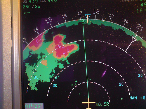
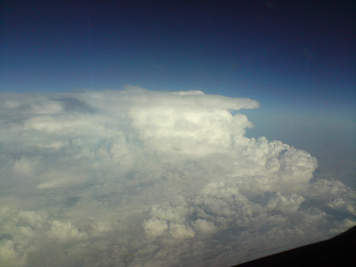
Sun, 7 Jun 2009 03:12:57 +0200
Out of personal curiosity I've been reading a lot on the web, including your interesting article about AF447.
If I understood it correct, your conclusion says the plane flew through 3 "spikes" of cold air rising upwards fast from the ocean surface, roughly described. On a pilot forum I found a post about an incident in the same area in 2001, where a plane suddenly entered a pool (about 40 miles in radius) of hot air (-19 C), which made the plane stall. http://www.pprune.org/rumours-news/376433-af447-16.html#post4978418.
In a related thread there's an interesting post suggesting that this could very well take the plane into a spin dive, which could also explain the "weird" differences in speed given from the pitot probes. http://www.pprune.org/rumours-news/376433-af447-17.html#post4978855
I'm curious what you think of their thoughts and if you found any info from your research of the weather satellites regarding warmer pools of air around the altitude of the AF447 flight path.
I'm not really a guy with a lot of insight in aviation or meteorology, just very interested. If you don't have the time - no worries :).
All the best
Ulf St--------
Sweden
REPLY: I do not agree that a bubble of warmer air (that is, any warmer than about
5 degrees compared to the environmental air) would have made it up
to flight level. This requires exceptionally high equivalent potential temperatures at some
lower altitude. The atmosphere has a tendency to overturn bubbles of hot air as soon as they
start becoming significant because "absolutely unstable" lapse rates are unsustainable.
We do see thunderstorm heat burst phenomena on the Great Plains at night, but this occurs due to
the downward forcing of a low-level inversion, and I can't picture a mechanism for
this to occur at flight level given the conditions shown.
I am not an equipment expert but perhaps an equipment malfunction from ice or an
issue with ram air temperature in the rapidly
changing wind conditions caused this.
But in regard to the above mention of an aircraft's "coffin corner"
(Wikipedia) it is
possible that wind values alone could greatly affected airspeed -- on Doppler radar we often
see anomalies of 40 to 80 kt at flight level within storms (Google "storm top divergence" for
some examples).
Sun, 7 Jun 2009 02:22:19 +0100
Congratulations for the excellent, accurate and non speculative work produced
Avoiding significant weather by on board radar is pretty tricky and can take you in to a trap.
It seems to be the case on the AF447.
Once inside the complex system expressed in your study the radar echoes will show what is ahead but will hide clouds behind depending on the range settings
You can turn right and left avoiding weather for some time but in the end, in a squall like that and precisely when you are almost out of it, your options are none.
You are facing a surrounding wall.
Considering the radar never failed during the weather crossing (and it could), pilots may have been out of options and, inevitably, crossed a highly active area.
From your excellent work and from my own experience, what your accurate graphics show no commercial airplane can take without some kind of damage.
How, why AF447 got there and the subsequent consequences are the questions.
I disagree with your statement However the analysis indicates that the weather is not anything particularly exceptional in terms of instability or storm structure.
The time of exposition, the length of the squall, the flight level and the conjunction of several adverse conditions make it exceptional, particularly at the ACARs report points.
The good news is that everybody will be aware of this tragedy.
Better communications, expanded air traffic control and better weather reports, like yours, frequently updated, may become mandatory for flight plans and operations in sensitive areas like this.
The significant weather can be pinpointed, the tops can be determined and updated for each flight level and safe routing options
On the other hand, all this black box fuss can be suppressed if the voice and data recorder permanently broadcast its contents to a central system on base.
At least that procedure (broadcasting) should be implemented by check list every time an emergency or abnormal event arises or in certain flight conditions.
It also would assist in case of hijacking.
Note (inconsistency in INTOL ATO may be caused by round up or down the real time over the report point. It is neither common nor right but could happen for a few reasons. If you have access to the previous position report it will state time over the previous position and the estimated time to INTOL. I suggest comparing the time overhead and the estimated time overhead INTOL to figure previous discrepancies)
Once again congratulations. Exceptional good work
Retired Airline Captain Pedro N. T-------
REPLY: Many thanks for the great comments!
Sun, 07 Jun 2009 09:08:56 -0400
At http://www.weathergraphics.com/tim/af447/ section 3 states :
This is excessive, because AF447 filed for M.82 and would have slowed to M.78 for turbulence penetration.
AF 447 was an A330-200; best turbulence penetration speed for the -200 is mach .80. Mach .78 is the best turbulence penetration speed for the -300.
From: http://www.a330jam.com/documents/turbulence.pdf
Richard L----------
Sun, 7 Jun 2009 17:47:20 +0200
I want to thank you for your evaluation of weather conditions AF447 may encountered during the crash. I'm not weather expert but an engineer who only try to understand what occured and why.
I found it by searching AF447 on the web and your article has let me anticipate what I read now about safety commitee in charge of investigations stating that weather conditions would not be so tremendous as newspapers wrote in the very first days.
I'm also interested by weather forecasts in particular because I sometimes enjoy to fly kites. In order to get more accurate than those general coming from medias, I know web sites in French regularly publishing data coming from models calculated for Europe. Let me know if you are interested to receive links from me.
I may be interested by links for accessing to some US weather free web sites including data coming from models, as I'm convince on strong relationships between weathers in Canada / American Lakes region and Europe (certainly stronger than media weather forecasts generally show).
FYI, my location is Nord-East of France, no so far from German border. Nancy is the main city where I'm close to.
Thanks in advance, regards,
Jean-Paul A----------
Sat, 6 Jun 2009 00:48:08 -0300
First of all, let I present myself. I work for the MetSul Weather Center in Southern Brazil. I am a member also of the Stormtrack forum, where you take part for many years.I have two of your books and, of course, I have great admiration for your work. The information provided by you on the disaster of the Air France plane is an excellent example of your superb and outstanding job. This Friday afternoon I was reading on the disaster of the Argentinean Austral airplane in 1997. The plane crashed in the Uruguay, a country that has borders with my southernmost state in Brazil (Rio Grande do Sul). My interest on the Austral 2553 crash was the initial cause indicated to the disaster at the time: a severe thunderstorm in the area. Well, twelve years later we know that the storm was only the beginning of the sequence of events that led to the crash of the plane. The Pitot tube got frozen when the plane flew trough the storm and the crew got wrong data on the plane's speed, That led to the crash.
http://en.wikipedia.org/wiki/Austral_L%C3%ADneas_A%C3%A9reas_Flight_2553
I was shocked to see a few minutes ago that the Airbus has sent a message with a warning on the Pitot tube - the same device that failed in the Austral disaster - and that it could have played a role also in the crash of the Air France plane.
http://www.bloomberg.com/apps/news?pid=20601082&sid=aRTRMJqJcXRs&refer=canada
Only the investigation will tell the final story, but it is shocking just to consider that a problem known for so many years and that is weather related could have a role in the fate of the AF 447.
Best wishes
Alexandre A---------
Sat, 6 Jun 2009 14:38:47 +0200
I much enjoyed reading your meteorogical analysis of AF447's probable track. One thing confused me: in writing "the airplane's final reported ACARS position (2014Z,3.578,-30.374)" and "the suspected final ACARS call at 2014Z", didn't you mean 0214Z instead of 2014Z?
David
REPLY: If it says 2014Z, then yes it's an error. Thanks.
Sat, 6 Jun 2009 11:25:08 EDT
Tim- I'm a B757 Capt with a major US airline. I've been following the Air France situation closely with both you and other websites. I kept hearing references to "supercooled water droplets"
that can form with the SAT below -40C. My flight manual directs me to not to use Engine Anti-Ice at Cruise when the SAT is below -40C. Does the possibility of ice exist when the SAT is below
-40C?......I checked my Flight Manual...and it makes not exception for when you encounter Weather at altitude, similar to what Air France encountered....
Chuck M---
Sat, 06 Jun 2009 12:55:51 -0700
I didn't see a link posted on the comments page or the Air France page,
so I'll send a couple of comments as well. I was stationed in the
central equatorial Pacific for 3 years and witnessed tropical convection
at its finest. We had a real issue with lightning and I did a bit of
research using our radar out there to help come up with predicting which
storms would produce lightning and which ones wouldn't. A long standing
criteria always seemed to be roughly 30 dBZ at 30kft for lightning.
From experience, I found that this was not always the case...while most
of our stronger storms were low echo centroid storms, we had a lot of
instances where there would be a tight reflectivity gradient near
30kft. Thus we would meet criteria...but no lightning. After doing
some further research into using radar reflectivity as a way to predict
tropical lightning, I found that two criteria really needed to be met.
Both the 30 dBZ at 30kft as well as 16 dBZ at 52kft needed to be met to
have a high likelihood of lightning. I don't know if anything can be
determined from the NASA Cloudsat imagery as to what reflectivity values
given a certain height...but this may indicate why little lightning was
observed...even though the convection was vigorous, it may have lacked
the necessary heights/ice formation needed for lightning generation. My
research was also for the central Pacific...so I'm sure there are
differences as well...
I hope this is of some interest and if you have any questions, let me know.
Kyle M------
Sat, 6 Jun 2009 14:45:27 -0300
your work was simply impressive.
Among lots of speculations, there is a VERY IMPORTANT report by a pilot.
http://www.aeroclubdetoledo.com/content/index.php/component/content/article/20-aviacion-comercial/44-airbus-330-air-france
An english translation was provided in pprune.org (http://www.pprune.org/rumours-news/376433-af447-15.html) and reads:
Hello Colleagues, I have a theory regarding the malignant potential cause of the crash of Air France's Airbus, and is based on my own experience. The meteorological phenomenon happened to me in the area where the plane crashed on May 9, 2001, when we returned from Buenos Aires with a B-747-300 TF-ATH enrollment, Air Atlanta flight for Iberia at that time. Since we overflight from Rio de Janeiro, still exactly the same route as the AF447 and passing through the area around the accident while crossing the ITFZ at FL-370, with a moderate to strong turbulence, in a matter of 1 to 2 minutes of flight, we experienced a sudden rise in outside temperature from -48 º C to -19 º C. As a result of this rise in temperature, we turn out to fly with a margin of 10,000 kg, to became 15,000 kg away from standards to that level flight, and with immediate initiation of an aircraft loss, with strong vibrations. We disconnected the autopilot and went down, losing 4000ft, founding us in the "coffin corner" meaning this that the plane was giving "loss" for high and low speed, and If we have not disconnected the autopilot and went down, perhaps today we would be in the bottom of the ocean making company to Air France´s plane; the autopilot would have tried to maintain altitude incrementing the power of the engines .... and that´d been impossible, and perhaps we would have entered into an abnormal position very difficult to recover because of the night and the spatial disorientation beeing into clouds.
Lately, I've been flying until February 2009 the A-340 and the "crisis" sent me to "dry dock"; having made lots of times the same route, Rio - Madrid I have not been back to this exceptional meteorological circumstance in 40 years working as airline pilot, it only happened once. I would describe as a huge funnel with a diameter of 40 nautical miles of extremely hot air and as a result of a forming CB or something similar, ascending to great heights, affecting us and after about 5 minutes flying with the "tight ass" it began again to normalize backing the temperature back -48 º C and then being able to rise again to FL-370.
According to the Airbus approach, flying in severe turbulence or strong, you do not disconnect the autopilot, but what is not expected it this kind of phenomenon that comes to my mind ... and if they didn´t disconnect the AP for not noticing this phenomenon (if it happened) in my humble opinion they may have been into abnormal positions and the plane may have been broken, this theory supports the order of messages ACARS (which are automated messages sent by the plane via satellite without intervenction of the pilots) received.
Is this report/theory compatible with the meterological situation you described?
If yes, this could be possibly considered the primary cause of the accident.
Sergio R---------
REPLY: See below.
Sat, 6 Jun 2009 22:49:50 +0200
There are some claims on PPRUNE that it is possible within CBs to have
"hotpatches" with as much as 30 degrees difference (-50 to -20 within
seconds), drastically reducing the coffin corner and possibly a
contributing factor.
Could you comment on this on your AF744 page please?
Bert
REPLY: See the question below for details.
Sat, 06 Jun 2009 11:59:34 +1200
Great analysis and well written.
Please consider the following:-
UN873
UTC W/P Lat Long True Mag NM GS
0133 INTOL 1 21.7S 32 49.9W
027.9 045.7 182.2 540KTS
0153 EPODE 1 19.4N 31 24.7W
027.9 045.7 62.7 540KTS
0200 ORARO 2 14.8N 30 55.4W
022.3 040.1 86.4 300KTS
0214 Final 3 34.7N 30 22.5W
Distances between positions are in Nautical Miles and Ground Speed in Knots.
Have you confused nautical miles with statute miles??
Barry C------
REPLY: Thanks very much -- your email has alerted me to a problem in my original estimates of airspeed
and I have updated that section Friday night as a result.
Sat, 6 Jun 2009 05:08:17 +0200
Hi, Tim,
have re-read your work, and have the following comments:
airspeed...mach....have a temp-relation. Maybe that accounts for the speed
difference ?
It is usually warm near the equator...
Another point: T/S systems can have their own micro-circulation pattern,
changing a
w-wind into an e-wind, or whatever. Maybe that´s a factor.
Regarding activity: have taken a closer look at the images available from
Dundee and
the Redemet (braz. airforce). It is really astonishing how the system
intensified - i stand
corrected regarding my previous remarks.
Please take a look at a Goes-Image from Dundee, 18z, 31-5-09
That would be the best that an airline pilot might get.
I have seen lots of systems like the one in question dissolve into
nothingness
between 18z on one day and 02z the other...don´t know why this one was
different.
Flight track: have seen the coordinates in your report now. Had overlooked
them
as there was no N / S or E / W with them, as is usual in aviation.
Can´t imagine why the airplane got where acars said it was. Radar failure
would
be my likely guess....
Klaus ---
Klaus also writes:
Hi, Tim,
many thanks for your fast reply.
The system looks like a strong but normal ´wall´ to me...
with the moon out, and the flashes, well, maybe something could have
been seen - we´ll never know.
Don´t know if it was really ´self-sustaining´ , active without sunlight.
I don´t see the typical mushroom-clound shapes on the pictures,
and no rotation, either.
I have flown around a lot of green dots on the radar, that showed
up as quite strong cb whn looking out of the window. Moonlight, starlight,
or even sunlight, it doesn´t matter.
Radar isn´t like Radar. These things need adjustment, proper care, and
can brake down, too. They need stabilization in 3-d, like the artificial
horizon
of an airplane. If there´s a problem - no radar picture. Don´t really know
what the colleagues saw - or were shown on the radar display.
Sometimes radar transceiver Left produces a very different picture from
radar transceiver right.... a case for maintenance-writeup, after landing -
if you notice it in time.
Anyway, would you know if the track of the AF during its last 30 minutes
of flight is known with certainty ?
Klaus
REPLY: Thanks, those are good points. I don't have any accurate coordinate information
on the last 30 minutes of the flight; much of what we know is anecdotal or estimated.
Sat, 6 Jun 2009 01:57:47 -0700
Concerning how well Hail is depicted on airborne weather displays, I thought you might find this excerpt of the Boeing 777 operating manual interesting.
Hail
Hail results from updrafts carrying water high enough to freeze.
Consequently, the greater the height of the thunderstorm echo, the greater
the probability that it contains hail. In the upper regions of a cloud where ice
particles are dry (no liquid coating on the particle), echoes are less
intense. Liquid water reflects about five times more radar energy than solid
ice particles of the same mass. Since hailstones are considerably larger
than water drops, and are usually coated with a thin layer of water, the echo
intensity from wet hail is greater than from rainfall.
It is not always possible to determine from the display whether the echo is
from hail or from rain. Instances have been reported of hail targets
producing finger-like protrusions up to five miles long and blunt
protuberances up to three miles from the edge of thunderstorm echoes. In
parts of the world where hail occurs often, extensions from thunderstorms,
shown in red, generally indicate a high probability of hail. This same type
display is also associated with new convective cells that may not yet contain
hail.
As with tornadoes, no uniquely distinctive displays are in all cases
associated with hail. Echoes from hail can appear quickly and along any
edge of a storm cell. These echoes can also change in shape and intensity
in a very short time. For this reason, close and careful monitoring of the
display is required.
Turbulence can be assumed to be present above any storm with severe
turbulence at the storm center, therefore, do not overfly such storms.
With such cold temperatures at altitude, it would seem likely any hail present may have had little liquid moisture on the surface.
Jim
Sat, 6 Jun 2009 12:15:27 +0300
Hi, I just read your article about the AF447. If it helps, the turbulence speed for an Airbus 330-200 is M 0.80, and you were calculating M 0.78. M 0.78 is would be ok for an Airbus 330-300, but the involved aircraft was an A330-200. I am an Airbus 330 pilot, by the way.
I hope this helps to improve the very good job you have been doing with this report.
Javier Ruiz
Sat, 06 Jun 2009 10:19:33 -0500
Sir....I am blown away by your depth and precision.. I am a commercial
pilot, former Navy P3, and I can't tell you how glad I am that people like
you are out there. I fly Int'l stuff now and it's a big pond out there.
Thanks for an interesting Saturday am reading.
Side-note- are you strictly math model based ? Do you ever look at planet
influences...specifically the moon?
thanks again...RB
REPLY: Due to limited amounts of observed data in that area of the world, most of the study is
based on a meteorologically-sound reconstruction of weather conditions. In meteorology
we don't consider planetary influences, though moon illumination was considered briefly
but largely ruled out (see below).
Sat, 6 Jun 2009 12:51:57 EDT
Hi, I used to be a Flight Dispatcher with the old PanAm for over 25 Years
and what strikes me is that nobody ever asked the question WHY the Flight was dispatched into KNOWN SEVERE WEATHER in the first place....only a slight change either in planning or en route could have given the guy a free ride...
Thanks Herb H----
Dispatch Ticket since 1960
Sat, 6 Jun 2009 10:15:49 -0700
First, thanks for an excellent writeup of the meterology surrounding
the AF 447 disaster. I am mostly writing because I think some new
details have emerged which might help fine-tune the weighting of
weather factors.
First, however, I want to address the Comet Air pilot's report has
suggested to some that either the pilot saw the downed plane or that
the pilot saw a meteor which might have downed the plain. I don't
think that either possibility is supported by the evidence. The
primary issues with the theory of the pilot seeing the pane are
distance (Wikipedia reports that the pilot was 1300 miles from the
suspected crash site, suggesting that the plane would have been below
the horizon) and the fact that the data suggests that the plane was
flying through a cloud (or exiting a cloud) when the problem occurred.
I can't imagine any circumstances where the plane would have been
visible to a northbound flight under the circumstances you have
reconstructed.
Regarding the meteor hypothesis, the main evidence to the contrary are
the ACARS messages which suggest a gradual breakdown in control
systems. These messages are more in line with you hypothesis of
gradual damage than any sort of sudden crisis. It seems to me that
the ACARS messages suggest a gradually degrading situation over about
three minutes, starting with airspeed sensors and ending in total
electrical failure. To my mind this time frame is far too long to
attribute to a single catastrophic event.
The ACARS messages, as reported in the media, however, provide a few
important clues regarding where to look for weather factors. The main
sequence is:
0210Z: Inconsistent speed readings, autopilot disengaged, alternate
law engaged.
0210-0213Z: Various systems failures
0213Z Main and backup flight control system failures. These include
systems which measure inertial forces, and later messages of the
rudder being broken.
0214Z vertical cabin speed (indicating a quick change in outside air
pressure due to either a decompression or a rapid descent)
From everything I have read, turbulence penetration speed (M0.78 in
this case) is necessary because if the aircraft is going too fast,
additional instability can develop along the control surfaces and this
can lead to more problems up to and including catastrophic damage to
the aircraft. The gradual breakdown of systems beginning with ISIS
units, strikes me as being consistent with severe turbulence and/or
overspeed issues. Consequently the key question to my mind is what
sorts of weather conditions present at that point when the airpeed
sensors failed (around 0210Z). The conflicting speed reading suggest
either damage to or obstructions in the pitot tubes, which measure
airspeed via air pressure readings, or electronic damage to the sensor
unit. Given that the first four hours of flight showed no problems, I
think we can reasonably conclude that ground problems, such as wasps
nesting in the tubes, can be ruled out. This suggests to my mind a
meterological cause for the problem. Thus the more important
questions in my mind focus on the time frame from 0200Z through 0210Z.
In this scenario, there are two stage to the problem. In the first
stage, occurring somewhere between 0200Z and 0210Z, at least two of
the three pitot tubes are damaged or obstructed. In the second phase,
from 0210Z through 0214Z, the airplane is travelling through
increasingly severe turbulence and at too high of a speed, causing
gradual physical damage to the air frame, electronics connections, and
control surfaces. The pilots would have had no way of knowing they
were flying too fast if the pitot tubes were damaged or obstructed.
Hope this helps,
Chris T-------
Sat, 6 Jun 2009 00:04:38 +0200
It's the most professional meteorological analysis of the potential event I've ever read in the Internet. I really admire.
Although all possibilities are just hypothesis by now, I'd like to know what is your opinion in regards to a positive charged lightning as a potential cause? It appears that new aircrafts are lightning protected. However it's important to understand that there are different types of lightning, carrying a different portion of energy. For example a positive lightning bolt (leader) can produce up to ten times more power than negative bolts (streamer), might be longer and it might strike much more far away from clouds. It seems to me that today?s planes, although protected against streamers, might not be not protected against leaders (?). I found this bulletin analyzing a story that happened in 1999: http://web.archive.org/web/20041009230137/http://www.dft.gov.uk/stellent/groups/dft_avsafety/documents/page/dft_avsafety_500699.hcsp. Moreover a positive charged lightning can originate from an anvil cloud (i.e. ?bolt from the blue?). With regards to your knowledge, data , and analysis abilities ?
could this be a serious thread for AF 447 at night July 1, 2009?
Best Regards,
Jan M-----
REPLY: The only thing we can conclusively say is the thunderstorm was capable of producing a positively charged strike, since
there were extensive, extremely cold cloud tops and a considerable mass of ice crystals in the upper part of the storm. Beyond
that there's no way of knowing the exact structure of the storm and how the charge centers could have been oriented.
The effects on an A330 are beyond the scope of this website, but if the aircraft has an established vulnerability to lightning
this would be a cause for concern.
Fri, 5 Jun 2009 21:20:32 -0400
Thanks for your comment. I don't want to speculate either, but considering the emphasis being placed in the press, (most journalists are woefully ignorant), I thought that some other possibility deserves consideration.
In-flight structural failure is so extremely rare. The only cases that I recall are the two Lockheed Electras in the 1950s where the wing broke up due to flutter vibration induced by the nacelle frequency, and the De Havilland Comets that broke up In India and Italy because of repeated cabin compression and decompression. Those problems were solved and such events never occurred again.
But that A320 tail failure was a completely new development.
Jean D-----
Fri, 5 Jun 2009 22:14:45 -0500
I am an EMB145 captain for a US regional carrier. Are there any remote sensing means for characterizing and analyzing an electrical charge field in the atmosphere? One of the current theories for the accident involves a discrepancy in the computer derived airspeed indicators. Based on my experience, this can result from the aircraft becoming charged to the point of St. Elmo's Fire.
Sumner ---------
REPLY: The remote sensing technology we have is rather poor for that part
of the world, and I doubt that anything substantial will ever be known about the electrical fields in
that particular storm.
Fri, 5 Jun 2009 22:50:40 +0000 (GMT)
Found these pictures. The're yours to use.
1-6 For the ITCZ type weather two of which I sent before. The visual shot I sent before is looking left of the aircraft with the sun behind the camera! All these shots are taken at 35 mm max wide aperture on my old compact camera. So we were pretty close! Note we didn't experience any turb. from memory.
5 of a big CB above a forest fire in the N America [near Abbottsford BC, Canada]. That only paints "green" note with high terrain the ground paints
quite well nearer to the a/c than normal. It looked pretty impressive, I caught some video too.
Cheers Andy

* ITCZ - About 10 deg left of nose (17.03.18 GMT)
* ITCZ - About 10 deg right of nose (17.03.26)
* ITCZ - Aircraft radar (17.03.34)
* ITCZ - Looking left, AC has turned left (17.05.10)
* ITCZ - Passing overhang on left (17.05.22)
* ITCZ - View to right (17.05.28)

* Green CB (03.26.28 GMT)
* Green CB (03.26.32 GMT)
* Green CB (03.28.02 GMT)
* Green CB (03.28.12 GMT)
* Abeam green CB (03.29.08 GMT)
Fri, 5 Jun 2009 17:15:18 -0500
Just a short note to compliment you on a truly excellent analysis. I am a retired meteorologist but my experience is limited to temperate zones (Canada). Your analysis was clear and useful and was such a relief to read after the huge quantity of useless opinion and supposition on the internet.
Robert Jacobs
Winnipeg Canada
Fri, 05 Jun 2009 19:08:22 -0400
If (as reported) the clouds and the weather were so poor, how did other flights claim to have seen
a flash or explosion? One or the other must be completely false.
Alan M----------
REPLY: Excellent question, and one that a few others have mentioned below. I actually believe this
sighting was possible as the evidence shows AF447 was probably breaking out of the north side of
the cluster or was about to, and there appears to be very little mid- or upper-level cloud north
of that area. Also if you look at crash videos like the Pulkovo Air Tu-154 crash, you can
see a brief but exceptionally intense fireball. These eyewitness reports appear credible.
Fri, 5 Jun 2009 08:32:06 -0400
You are doing everyone a great service with your comments on the Air France disaster. If possible, perhaps you could preserve the date-time stamp on your incoming messages. That would make it easier for people around the world to distinguish what is new, compared to what they read several hours earlier.
James M------
REPLY: Thanks, I would like to do that but it has been extremely difficult to
keep up with posting the comments -- transferring the times would
add to the workload. Hopefully I can fix that when things slow down.
The newest content is always at the top of the page.
Fri, 5 Jun 2009 14:31:21 +0200
i am an airline pilot, and have seen your updated analysis of the af flight. My comments:
a) your analysis is detailed and certainly most accurate.
The question is, if the af flight followed the flightplan route....
From experience, i can assure you that track deviations due wx are normal
on the south atlantic tracks. For deviations larger than, say, 10 nm you´d request
a clearance...
b) Your radar picture looks nice - but is it reality ? Moisture tends to leave the tops
of the cb´s near the equator fast after sunset. What would be a red area during
day might look green on the radar after midnight.
c) What about the visual cues ? Would the system on the planned af track have
shown lightning ?
d) What about the moon ? On a clear night, it is a valuable safety-tool, supplementing
radar . Would the moon have been out at the time of the af-flight ?
Klaus S-----
REPLY: Very good comments. I believe the radar picture is fairly accurate, at least as good as I can get it, and it
shows fairly good verification against the CloudSat imagery. This system was much more organized than a typical
tropical thunderstorm, and is what we call a mesoscale convective system; it does not rely solely on diurnal heating
and can persist throughout the night. I do believe lightning would have been seen but due to extensive in-cloud flashes
and lack of depth cues through the cloud it would be very hard for flight crews to pick out where severe cells
are occurring. As far as the moon goes, there was a first quarter that would have been low in the western sky, not providing much
light. A full moon can be of great help with isolated thunderstorm cells but in a massive
MCS such as this one, the system would be too large and extensive -- even in daylight this system would appear as
amorphous mass of rain and embedded cumulonimbus towers.
Fri, 5 Jun 2009 14:15:21 -0700
What an excellent analysis you provided.
I'd like to comment on the cruise speed to which you referred in a couple of places. In particular your questioning the fact that one scenario lead you to a cruise Mach number of 0.83. It's my understanding that the Optimum Long Range Cruise Mach Number for the A330 lies between 0.82 and 0.83. I would guess that it's very likely, therefore, that the 0.83 scenario is quite probable.
Darol H----, Retired Boeing dynamics engineer
Fri, 5 Jun 2009 20:14:27 +0000 (GMT)
I've found two photographs of ITCZ weather for you to use as you wish.
One visual, the other radar. About 1 minute apart.
I can't swear the visual picture is directly ahead, but I think it was, if not its out to the left. It was over N. Africa about
5/6 pm local time, so the sun should be in the west. So using shadows you can get the exact bearing I think.
We were heading south. Can't remember which direction we turned next! You can see from the map that we are already 10 miles
to the right of track. But it shows very well the information as portrayed on a radar.
Note the radar is -4 degrees, magenta colour is radar predicted turb and full range is 80 nm. The 40 indicator being half
range. I think the radar beam is only 2 degrees wide or so.
Andy

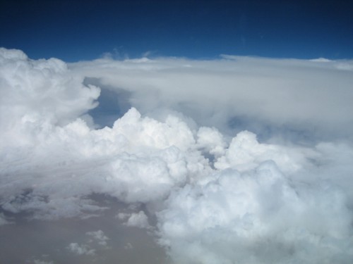
REPLY: Thank you very much! Nice images! This is an area of scattered multicellular thunderstorms in many different
phases of their lifecycle from young new updraft (towers on left side of window image) to decaying anvil cloud (horizontal
cloud on right side of window image at flight level). For comparison purposes, the AF447 multicell system would have
filled much of the radar display, and a shot out the front window if it were day would probably show dull gray featureless
cloud (mostly thick anvil with precip and rain) with a few murky towers as the aircraft approached the cluster.
Fri, 5 Jun 2009 09:55:10 +0000 (GMT)
A quick note to say ` brilliant job` - whilst i don`t work within the indusrty , i am just an avid private single engined pilot , but saw your work linked on PPRUNE , being used by other more active commercial pilots in discussions on what might have happened.
Fantasic , and i hope you get all the credit where it is due for the effort you have put in.
A heart felt `thank you`
simon h--------
Fri, 5 Jun 2009 22:24:37 +1000
Dont think I saw this one mentioned to date. After plowing across the Pacific and Atlantic for many years and stumbling into the occasional CB ( the storm lines are so long across track its unavoidable at times)
Autopilots kick out or are kicked out because they cant handle the savage turbulence . Mach numbers can fluctuate wildly due a combination of turbulence and rapid temperature changes within the cell. Quite a few times mach warning horns, on a number of different types I have flown , have sounded , as the conditions push the aircraft into the transonic region. I am not sure of the transonic handling characteristics of this aircraft, but it is just one other factor to bring into play in this scenario.
Geoffrey W----
Fri, 05 Jun 2009 14:33:49 -0400
I add my voice to the many others commending your brilliant and
detailed analysis.
One item I noticed and which I don't believe has been referenced elsewhere...
The flight plan data found on your Web page includes the following:
"INTOL/M082F350 UN873 SALPU/M082F370 UN873..."
Decoded, this means the flight intended to cross INTOL at Mach 0.82
and FL350, proceed along the UN873 airway and cross SALPU at Mach
0.82 and FL370. In other words, the canned flight plan called for a
cruise climb from FL350 to FL370 between INTOL and SALPU.
Your work and the informed speculation of many familiar with the A330
doesn't reflect this aspect of the flight plan and, while I doubt
seriously it is of any real import to determining what became of
AFR447, I write merely to bring it to your attention.
Again, thanks for all your fine work.
Jeb
REPLY: Thanks, I never worked dispatch so your post is enlightening. That leaves the remaining question:
when and where they decided to slow down to turbulence penetration speed (M.78 or lower), if in fact they did.
Fri, 5 Jun 2009 02:39:39 EDT
I retired from TWA and flew the north Atlantic in L-1011s. I am now a pilot instructor with a major airline on the B757/767 for transpacific and north Atlantic operations. As an aerospace engineer I feel that your analysis of the weather conditions associated with the Air France accident is outstanding. Congratulations on a fantastic job.
Were you aware that this is the second major accident involving extreme weather and an intercontinental Air France Airbus transport in four years? In 2005, Air France Flight 358 was involved in an serious accident at Toronto Pearson International Airport. The airplane overran the runway and crashed, subsequently being consumed by fire. All 321 souls on board were able to evacuate without casualties.
That Air France flight landed during a severe thunderstorm, which caused the accident.
The point of interest here being that the Transport Safety Board of Canada (TSB) in its final report of this accident determined that Air France did not have procedures established for its flight crews related to the distance required from thunderstorms during approaches and landings.
The latest accident involving AF447 raises the question of whether Air France has in its flight operations manuals detailed guidelines and procedures for thunderstorm avoidance enroute. Could it be possible that Air France does not have thunderstorm avoidance policies in place for its flight crews? These two accidents apparently caused by severe weather appear to indicate a disturbing trend.
Congratulations again for your splendid analysis. You are indeed, a true professional.
Maurice
Fri, 05 Jun 2009 09:46:58 -0400
Thank you for that fascinating analysis! You mentioned that a groundspeed of 580 was not likely---I just read in the WSJ that one theory is that the pitot tubes iced over sending
inaccurate speed data, and the pilots may have increased speed dangerously in response. Maybe the 580 is correct.
Leigh B---
Fri, 5 Jun 2009 09:55:43 -0400
I found your name from your fascinating site about the recent Air
France flight lost in the Atlantic. My interest in meteorology and
aviation helped me find your discussion, but my life's interest is in
birds, specifically bird migration. In the last 15-20 years I have
become extremely interested in tracking bird migration with radar,
acoustics and other means, and how this might relate to various scales
of meteorology and climate. I've started to focus my interest in
recent months on an old project of mine, modeling bird migration with
weather data - the impetus to revisit some of this work is the
proposed expansion of alternative energy, namely wind power, in the
coming years and the fact that we know little about how such expansion
will affect migrant wildlife. Background aside, I have been thinking
about potential collaborations with folks that really know weather - I
wondered if you might be interested in discussing some ideas about
bird migration, weather, modeling, and the science behind it? I am
currently a postdoc at Cornell Lab of Ornithology, where I study
flight calls of migrant birds. The acoustic side of life has forced
the radar to take a professional back seat, but I still pursue it in
extracurricular ways. . .
In the mean time, I look forward to the next update about the lost
flight. A sad and strange tale, to say the least, but hopefully one
from which we can learn something. . .
Regards,
Andrew
Fri, 5 Jun 2009 10:20:24 -0500
Compliments on your professional WX analysis relative to the recent Air France crash, especially for the discipline of not speculating on the unknowns regarding the 'Bus and its systems.
I'm Bill ------, a recently retired B727 pilot (24 years with different companies) at Capital Cargo. We always said "if it ain't Boeing we ain't going". I admit to being biased against any airplane that restricts the flying pilot from complete control (via computer given control authority); and also which has a spotted record of structural integrity -- the crash into NYC where AA lost a tail component. The Airbus is a minimalist machine whose construction seems to have put aside the contributions of actual pilots in favor of non-aviation ground personnel from the communities of marketing and accounting.
Throughout my flying career weather was always a significant player, and dedicated individual like yourself made our jobs safe.
Blue skies,
Bill ------
Fri, 05 Jun 2009 09:33:59 -0700
I wish your highly impressive analysis (and done very quickly/efficiently too) was much more routinized in both commercial flight planning and in-flight management. A few quick observations (FYI, I'm a 30 year aviation professional with 10,000 hours of total flight time primarily in civil business and regional jets).
1. Your comment, "However the analysis indicates that the weather is not anything particularly exceptional in terms of instability or storm structure" may be a bit misleading. The weather may indeed have been representative and 'unexceptional', but it was representative (it seems) of severe weather. Unexceptional does not lessen risk to flight operations. All weather systems on this planet fall within a range representative of all possible weather generation. And again, 'unexceptional' can also be severe and highly hazardous. The planet experiences numerous severe convective events a day, all unexceptional and many yet severe.
2. You state, "It's my opinion that tropical storm complexes identical to this one have probably been crossed hundreds of times over the years by other flights without serious incident." This may indeed be true; however it may be more accurate to state that TSCs have not been penetrated hundreds of times (circumnavigated, yes; flown over, yes. Penetrated directly, at FL altitudes in a core level 4/5 mature/developing cell? I don't believe the flight completion statistics support even irregular severe cell direct penetration).
Your expert analysis seems to indicate that this AF flight flew head-on, dead center into the worst part of a highly dynamic developing cell. It likely contained, and the flight likely encountered, all of the phenomenon associated with this kind of weather event: moderate to possibly extreme turbulence; lightning and a mix of precipitation types and intensity.
Any or all of these storm products may or may not be causal. However, the many expert opinions expressed here create a rich data field that confirm both the hazardous and occasionally terminal results of cell penetration, even into lesser cells or clusters. Moreover, the expert reports here also attest to the probability of various and potentially terminal aircraft and system failures resulting from such penetration.
I know of no professional pilots that would have ventured as close to this line of weather as this crew apparantly chose to do. And I know of no professional pilots that would have taken a gamble by penetrating such a severe weather field. Imagine a routine US continental flight doing so; it is nearly unheard of. A possible primary causality in this case may turn out to be the one responsible for the vast majority of flight incidents and accidents: pilot error.
It was interesting to note from all of the seasoned pilots and especially the ones traversing remote oceanic regions, just how crude and unsophisticated our current weather avoidance technology and procedures are. Aircraft radar is a notoriously innacurate device; many are "out of tune" and too many pilots under-trained in its use and limitation. Indeed, most oceanic professional pilots manage convective events with a mix of radar, eyeballs (daytime or from moonlight and or lightning flashes) along with a bit of luck and hope.
In contrast, US continental flights have a mix of intelligence sources that make convenctive avoidance almost routine: dense, current flight activity with near real-time pilot reporting; rich, multiple airborne and ground-based radar; multiple commercial and government flight tracking and weather analysis, along with rather conservative flow procedures at the terminal and airport level that adjust (retard) to weather disruption and therefore preempt severe weather flight penetration. The oceanic regions? You're pretty much on your own. A sad and utterly unecessary condition, as your analysis so dramatically demonstrates.
Thank you for such a professional analysis (and lesson). Perhaps the weather under question wasn't 'exceptional' but your work here surely is.
Best regards,
MG A------
REPLY: Thanks, I will try to adjust the wording you mentioned -- the main emphasis here is to emphasize that these storms were
not in themselves extraordinary for the region they were occurring in. Indeed as you point out the effects of flying through them, however, can be quite extraordinary.
In regard to the other issues, I should reiterate there is no conclusive evidence that the A330 penetrated the
worst part of the storm. In fact it looked to me like the flight deviated slightly west of the track to avoid the "Big Kahuna" cell located
just to the east, grazing AR873, but it would have still brought it over other updraft areas. The data is still
somewhat sketchy and this is all a best guess scenario.
Fri, 5 Jun 2009 13:02:41 -0400
Tim,
(We've had contact in the past; I bought some of your software a few years back. I run a small company (WXSYS Corp.) providing aviation weather and airport information services to BlackBerry handhelds and other mobile devices).
I also fly jets for a large airline.)
Good article re the weather existing at the time of AF447's loss in the Atlantic. Thanks for taking the time to do that.
Granted, much of it is too technical for the interpretation level required by airline pilots, but the conclusions you offer are not unreasonable - and they are helpful in the larger task of trying to make sense of this tragedy.
However one 'burr edge' stands out with the conclusions related to your assertion in Section 4 of your web page on the topic.
While I absolutely agree with your conclusion in that text that hail (or sizeable hail) is unlikely at that altitude in that area under those circumstances, I struggle with your additional assertion that:
"airborne radars are highly sensitive to hail because of the strong reflectivity of ice particles"
I've been flying for a career for twenty-one years, nineteen of which have been in jets, worldwide.
Much of that flying has involved high-atltitude flight across the tropical Atlantic, traversing the ITCZ.
Never, in my experience have I witnessed a radar return indicating dry or ice crystals hail on modern radar, there, or anywhere else.
Furthermore, most airlines (presumably based on the information provided by weather radar manufacturers), counsel their pilots that dry hail and ice particles are not particularly reflective on airborne radar.
To the contrary, aircrews are taught that airborne radar cannot be relied upon to directly indicate the presence of dry hail or ice crystals at high altitudes.
I expect that may be a valid teaching point, based on my own experience.
You might want to refine your assertion about the strong reflectivity of ice particles when viewed by airborne radar.
Best regards,
Alan B-------
REPLY: The most powerful reflector of radar energy is unquestionably large, wet hail.
This is partly because the reflectivity of electromagnetic energy (Z) increases sharply with the particle's size.
However dry hail does produce lower reflectivity values and there is indeed a greater possibility of weaker echo returns in the upper parts
of the storm as freezing of supercooled water on the hailstone would probably be complete at the temperatures encountered at FL350.
Foote et al. (2005) state:
"The measurement of hail with conventional radar is a problem. The main difficulties are connected with the unknown contribution of
rain to the total power that is backscattered to the radar, the size distribution of the hail, and to perhaps lesser extent
the physical nature of the hailstone that affects its backscattering properties (existence of a water layer, spongy
property, etc)." These are variables that do cloud some of the truth about what was seen on the radar.
I will reread the study and adjust it slightly where needed. I greatly appreciate your input in this area!
Followon comment:
I concur; not all hail shares the same reflectivity, hence my calling to attention the likelihood of diminished reflectivity of 'dry' hail which can occur at higher altitudes, if conditions permit.
(Personally, I share your belief that hail would have been an unlikely factor in this tradegy, but it still would be helpful to make this distinction between dry and wet hail reflectivity - particularly for people who may try to apply your conclusions to future airborne practice.)
Keep up the good work.
Fri, 5 Jun 2009 18:58:39 +0200
very impressed with everything going on at your site. The community, support and communication here is outstanding.
I found Australian government information on the severe Quantas Airbus 330 flight incident on Oct 7th from Singapor to Perth (?).
The focus is on the malfunction of a faulty ADIRU 1, and its incredible consequences for the cockpit crew.
Would it be possible to analyze and compare the frequency of events in this case with the data available from AF 447.
What would be the result of simulating the Quantas incident with the weather situation of AF 447? Could this generate new, insightful data?
Airbus spoke from a single event back then. But in fact, there was another one.
?The aircraft was flying at FL 370 or 37, 000 feet with Autopilot and Auto-thrust system engaged, when an Inertial Reference System fault occurred within the Number-1 Air Data Inertial Reference Unit (ADIRU 1), which resulted in the Autopilot automatically disconnecting. From this moment, the crew flew the aircraft manually to the end of the flight, except for a short duration of a few seconds, when the Autopilot was reengaged. However, it is important to note that in fly by wire aircraft such as the Airbus, even when being flown with the Autopilot off, in normal operation, the aircrafts flight control computers will still command control surfaces to protect the aircraft from unsafe conditions such as a stall.
The faulty Air Data Inertial Reference Unit continued to feed erroneous and spike values for various aircraft parameters to the aircrafts Flight Control Primary Computers which led to several consequences including:
false stall and overspeed warnings
loss of attitude information on the Captain's Primary Flight Display
several Electronic Centralised Aircraft Monitoring system warnings.
About 2 minutes after the initial fault, ADIRU 1 generated very high, random and incorrect values for the aircrafts angle of attack.
These very high, random and incorrect values of the angle attack led to:
the flight control computers commanding a nose-down aircraft movement, which resulted in the aircraft pitching down to a maximum of about 8.5 degrees,
the triggering of a Flight Control Primary Computer pitch fault.
The crew's timely response led to the recovery of the aircraft trajectory within seconds. During the recovery the maximum altitude loss was 650 ft.
The Digital Flight Data Recorder data show that ADIRU 1 continued to generate random spikes and a second nose-down aircraft movement was encountered later on, but with less significant values in terms of aircraft's trajectory.
At this stage of the investigation, the analysis of available data indicates that the ADIRU 1 abnormal behaviour is likely as the origin of the event.
The aircraft contains very sophisticated and highly reliable systems. As far as we can understand, this appears to be a unique event and Airbus has advised that it is not aware of any similar event over the many years of operation of the Airbus.
Airbus has this evening, Australian time, issued an Operators Information Telex reflecting the above information. The telex also foreshadows the issue of Operational Engineering Bulletins and provides information relating to operational recommendations to operators of A330 and A340 aircraft fitted with the type of ADIRU fitted to the accident aircraft. Those recommended practices are aimed at minimising risk in the unlikely event of a similar occurrence. That includes guidance and checklists for crew response in the event of an Inertial Reference System failure.?
Be well
Götz
REPLY: This is getting into aircraft systems design issues and this is not my area of expertise. It's impossible to
know the exact forces that acted on the plane until the FDR is recovered.
Followup message Fri, 5 Jun 2009 22:58:57 +0200:
Sorry, I missed parts of the bigger picture in my first entry. You´re right,
I should have addressed this question to the flight crews in this forum in
the first place. My concern is about the translation/interpretation
interfaces do between nature and automated computers. And if too much
expertise has been taken out of the hands of crews in modern times.
Ben Sandilands comments on his blog "Plane Talking" about possible
difficulties with external sensors through icing on AF 447, and wrong
messages to the flight desk.
http://blogs.crikey.com.au/planetalking/2009/06/04/af447-flown-at-wrong-speed-through-turbulence-prior-to-in-flight-breakup-according-to-le-monde/#comments
The Quantas crew could handle it. But it got very close to disaster. AF 447
weatherwise was in a very bad situation already, which could have led to a
fast chain reaction of misperceptions and wrong conclusions under incredible
pressure and stress on the crew, especially at night where spatial
orientation is tough. In case of the 330 they speak of three back-up
systems, which all seem to have failed. How is that possible?
Part of the incredible response to your blog points at a big demand for much
more sophisticated professional training of flight crews in difficult and
challenging weather conditions. There is a total connect between you and the
pilots in this forum here. Something needs to be done with that.
I feel this very strongly.
We owe those 228 people lost on board AF 447 the best we can possibly give.
Keep up the brilliant work!
Kindest regards
Götz from Germany
Fri, 5 Jun 2009 04:12:49 +0000 (UTC)
Fantastic read Tim. Best analysis I've seen so far. I've posted a link to your site on our internal pilot's board. In this age of penny pinching, I hope weather analysis like yours makes companies live up to their motto of safety by flightvplanning better routes, giving the crew the authority to make significant deviations when needed and last but not least, providing up real time weather info (Charts, satellite images,etc) to crews while they are flying. Thanks.
Antonio V---
Continental Airlines
First Officer B-737
Fri, 5 Jun 2009 13:48:29 +1000
Thanks for the opportunity of adding what I consider to be an element overlooked by numerous airline companies. Lightning strike.
I have 32500 flying hours and feel what I have to say here is very relevant.
I will outline 2 incidents that I personally experienced in which I consider could have esculated into a far greater prolem.
1. Dash 8 aircraft. While cruising at Fl230 we were hit by a strike that felt like being hit by a locomotive. All appeared ok but I reduced to Turbulence Penetration Speed and remained at this for a return to the departure point.
On arrival, it was found that the strike had burned a large hole in the elevator and a smaller hole at the exit point in the l/h aileron. I feel that among other things, damage like this could cause flutter in the control surface and at high speed would lead to failure.
2. Dash 8 aircraft. While climbing through FL140 and CBs 15-20 mile either side but aircraft in the clear (night flight) we were hit by a strike that put out all radios, navigation equipment and all main flight instruments (Transponder remained operating).
I won't elaborate further here but to say speed was reduced to Turbulence Penetration Speed and a safe landing at destination. (Circuit breakers were popped everywhere).
Inspection revealed that the radio aerials had been blown out and a hole requiring a patch and 200 rivets on the belly plus the replacement of numerous electrical components and radios.
In summary, I feel it imperative that when a strike occurs that aircraft immediately reduce speed as crew don't know what is just "hanging in there" .
Your opinion would be appreciated.
J. G------
Thu, 4 Jun 2009 23:01:10 +0000 (GMT)
I read your work about flight AF 447 and I was very impressed even if I did not understand everything.
Congratulations!
But I have one question and I do hope, you could help me in this matter.
I was one of the "lucky" passengers, who took the flight AF 443, which took off from Rio on the same tragic
day (05/31/2009) at 04:20 p.m. (brazilian time). I usually do not sleep on flights, so I watched films or just read
something. Since I arrived in Zurich, where I live, the news about the AF 447 are 24 hours in my mind questioning: Were
we just lucky?
1. Could you tell me how the weather was at that moment, when we passed the probably crash zone of AF 447? Some weather
graphics in example
2. I can recall that the crew told us to fast our seat belts just after we passed Natal, because of turbulence, but
honestly I did not "feel" any shaking or something like that.
I know, my question is not a professional question...just a personal one. I am having problems to sleep and maybe
seeing pictures of the time I was underway, it could help me to understand the whole thing.
Thanks in advance for any help from your side!
Paulo A---------
REPLY: It is fortunate that fate took your plans in that direction. To briefly answer your questions, much of this
depends on the exact routing of your aircraft so I am not certain. It is possible you passed an entirely different
part of the MCS or went around it -- things can change very rapidly.
Thu, 04 Jun 2009 12:17:03 +0400
The CF-6 fitted to the Air France A330 doesn't have the best record in
heavy precipitation/ icing.
See the link...
http://www.pprune.org/rumours-news/229559-qatar-airways-a330-dual-engine-flameout.html
Miles K--------
Thu, 04 Jun 2009 16:16:54 -0700
Looking over your detailed analysis of weather formations in the flight path of AF 0447, it made me think of other less common weather phenomenon, such as meteors and space junk debris. I then remembered that on June 1 the asteroid KR21 was supposed to be in close proximity to the earth. Within a 0.7 LD according to spaceweather.com website . Could debris from this rather large asteroid, 21 meters in size, filter through the earth?s atmosphere and have a direct strike on the aircraft? I know this sounds highly improbable, then again so are all the other theories such as a lightning strike or hail storm bringing down a modern aircraft equipped with all the latest flight technology. Do you know of any means of tracking meteor debris or space junk debris via orbiting satellite or radar? I wonder if such data could reveal a different story to the demise of AF 0447.
Thank you for your research and taking the time to share it with all of us.
Best,
MA
Thu, 4 Jun 2009 17:08:41 -0700
I enjoyed reading your discussion of factors, particularly weather factors, surrounding AF 447 accident. I fly the 777 internationally and would like to offer a couple of thoughts based on my experience with that FBW airplane. While the systems will certainly be different, I expect the design philosophy and certification requirements give them very similar characteristics:
Loss of the ADIRU(s) could be the result of bad air data such as would occur if the pitot tubes were damaged by hail.
This could result in simultaneous Over speed and Stall warning indications along with erroneous airspeed display.
The autopilot would disconnect because it would recognize it had only bad data.
This would leave the pilots hand flying with conflicting warnings and erroneous airspeed data.
The envelope protection function of the flight control computers, working with bogus data, could provide inappropriate feedback to control inputs.
Hail strong enough to take off the pitot tubes could cause the engines to flame out, although they should automatically attempt a relight.
The PT1 probes that measure inlet pressure to the engines as in input to the fuel control could also be damaged by hail, preventing a relight.
Failure of the engines would cause loss of cabin pressurization and loss of primary electrical power.
The APU should auto start and the RAT should drop in this situation.
The RAT might be damaged by the hail and fail to operate.
If the APU started it should power up the entire airplane.
Is it known if this airplane had an operative APU and if it did does the ACARS reported date indicate it started?
With APU power the airplane could have remained controllable although it would be very difficult with bad airspeed indications, bogus warnings, and possible loss of engine power.
Without the APU or RAT, the airplane would be down to battery power for flight instruments and flight controls and hydraulic pressure from the engine driven pumps, assuming the engines were wind milling at sufficient RPM.
At best this would have allowed a "controllable" ditching on a dark night at sea. Something with not a high probability of success. In any event it appears the aircraft broke up in flight
Just some random neural firings to add to the brew.
Thanks for your rigorous efforts to ferret out the truth.
Captain Jim M-----
Thu, 4 Jun 2009 20:35:40 -0400
Just wanted to congratulate you on an excellent presentation.
As an airline employee (non flight deck) I take great intrest in these things.
A few years ago, a BMI flight from Cyprus to MAN . Enroute they experienced a weather event , as detailed in the below report
http://www.skybrary.aero/bookshelf/books/320.pdf (PDF)
In this case there were some questions raised as to if the pilots read the WX radar correctly, as the aircraft behind took evasive action to avoid the storm.
Great website and article, bookmarked for future reference.
Jim H----
Thu, 4 Jun 2009 13:22:51 +0200
I was reading your excellent page on Flight 447. I?m not a meteorologist but I feel like I have an interest in this case: In April 2006, I flew on a charter flight from Fortaleza to Budapest. A half an hour or so after departure ? i.e., more or less at the location where Flight 447 went down ? we suffered massive turbulence. I?ve experienced significant turbulence before, but this was something of a different order. I think we may eventually have stalled, because it felt like the plane just stopped, and then we suddenly took a dive ? all the women and children were screaming by this time. Fortunately, the dive ended after a minute or so. (Then the pilots took the plane up and up to a far higher altitude.)
Re current weather conditions: I checked out the FNMOC site for sea surface temperature anomaly ? and it does seem that the ocean was significantly warmer than normal by the Brazilian coast and then significantly cooler than normal from about the equator onwards.
Could this have been a factor ? possibly making the turbulence even worse than normal? Note, the plane seems to have gone down at the intersection between the warmer-than-normal and cooler-than-normal waters. https://www.fnmoc.navy.mil/ncoda_web/dynamic/ncoda_1440x721_global_anom.gif
If this was a factor ? it could still be a source of danger (?)
Andy G----
Budapest
REPLY: From a thermodynamics standpoint the actual sea surface temperature is the important
thing, and in this case we have well-established values from a couple of ships.
Both sea and atmosphere are about 27 deg C around the crash region and it has good
consistency with the instability estimates that we computed.
Thu, 4 Jun 2009 07:46:10 -0400
I read with interest your analysis of the Air France flight meteorological environment. With regard to icing, I concur with your assessment that aircraft icing is not significant at temperatures below which water is predominantly in a solid state. However, recent work done within the aircraft engine industry in cooperation with the FAA has led to understanding that this type of environment can threaten engines, even at the high power level consistent with cruise operation. I attached two papers on the subject, one dealing with the ice crystal concentrations that are possible in such environments and will form the basis of new FAA engine icing certification rules and the other dealing with the analysis of ice accretion within engines due to ice crystals.
Robert M-----
REPLY: Thank you for these. I haven't placed them on the comments page
as I'm not sure we have reproduction rights, but I will check them out.
Indeed I know from my preliminary Google searches there are quite a few websites out there discussing
turbofan icing issues in depth.
Thu, 4 Jun 2009 08:39:15 -0500
An outstanding analysis of the weather Air France 447 encountered. Your work will help the
investigation and has helped remind us all about the dangers inherent with convective activity.
You and I must have crossed paths at Tonopah Test Range, Nevada. I flew in I Unit/415 TFS and
then the 417 TFS from
Oct ?88 until Jul ?92 when we shut the Tonopah wing down.
As a Southwest Airlines Captain we don?t encounter the extreme conditions Air France did but, we do see some pretty nasty lines of weather as we cross the U.S. Is it possible to animate the probable radar depiction to give us a better idea what the crew might have seen as they approached the MCS cluster?
Thanks again for the great job,
Blake B----
Thu, 4 Jun 2009 15:42:44 +0000
Read with great interest your link Air France Flight 447 meteorological analysis .. and posted this link on the Royal Air Force Forum.
With respect to the recent Air France event, would it be possible for you to include the two (attached) photos in the above link, as exemplars of the 'Cunims' found at that latitidue and region?
These two photos taken last summer by my son Steve Webb, while on a Lufthansa Flight from Frankfurt to Malabo, Equatorial Guinea .. pictures taken on the very last stage flight over the Gulf of Guinea. I seem to recall Steve mentioning flight level was at 34,000 ft.
Noted from your home page you were at Mombasa .. was a 'sinful' place when I was there in '61 - the Rainbow Bar .. had to hightail it out of there one morning for, what was then Tanganyika, (another story, best left unsaid!)
Neville
(Newfoundland and Labrador)


Thu, 4 Jun 2009 22:45:19 -0700 (PDT)
I wanted to thank you for the article, it was very interesting. However, I believe that your assumptions
regarding hail do not fit the FAA and ICAO International SIGMET definition where hail is included. Hail can
cause severe damage when encountered and has caused airliners to go down here in the U.S. My former meteorology
ground school instructor (former U.S. Air Force Colonel Wilhoit chief meteorologist at NORAD Cheyenne
Mountain) said that hail is ever present at commercial operating altitudes when International SIGMETS
are encountered regardless of topographical position; although, I agree that hail was not encountered
during the accident and not a factor. I would like to give you some insight as to damage that is incurred
during operations at altitude; since, it can be agreed that hail will cause damage regardless of where
in the world it may be encountered. I will provide this link to an article at the Aircraft Owners and
Pilots
Association website that may give you some direction into future theoretical prognosis of hail damage
in commercial airliner accidents. The article discusses the factor of hail in the April 4, 1977 accident
of a Southern Airways DC-9 including a last minutes transcript of the cockpit voice recorder, which offer
also offers some valuable information as to the encountering of hail as a factor in the altitudes you
have discussed in your analysis.
http://www.aopa.org/asf/asfarticles/sp9808.html
Thanks, Ramon N---------
REPLY: Thanks; there is some great information here.
Thu, 4 Jun 2009 12:01:47 -0400
Excellent Analysis. I checked out on the Airbus A-310 and did not care for it, I also checked out on the Boeing B767ER and flew the Atlantic and loved it. I was also an Air
Traffic Controller in NY Center and worked in Aerology in the US Navy. When I heard of the accident, I immediately thought of AA587 on November 12,2001 which came
unglued due to wake turbulence. The NTSB attributed the crash to abnormal rudder inputs and also the failure of composite hardware associated with the Rudder Assembly.
I am totally unaware of the construction of the Airbus A330 and I am concerned that the two disasters may be connected as was Bill Rice of Delta.
Captain Nicholas G------ Jr.
Thu, 4 Jun 2009 12:34:54 -0400
9000 hr. Pilot retired from the Commonwealth of Virginia
The A320 that crashed in New York came to mind when I heard of this flight. It was mind-boggling to realize how that Vertical Stabilizer completely separated in flight. Does this model have the same control design?
William J----
Thu, 4 Jun 2009 14:52:43 -0400
Excellent analysis of the weather. I remember seeing your forecasts on AFKN when I was at OSAN, AB in 94-95.
I was a weather forecaster at the Osan base weather station. I always loved watching those U-2's take off.
I retired from AFW a couple of years ago, but keep practicing it at the 174th.
You are a great example of the superior meteorological skills that most of us in Air Force Weather have learned.
MSgt Ray L. C--------- II
Thu, 04 Jun 2009 21:09:54 +0200
I am peter from berlin with a question:
can it be that we can [mark] a flying airplane on an IR-meteosat picture?
I know 1 pixel will be around 1 by 1 mile, but the air behind an
airplane is very hot
can it be that the air is hot enough to be seen by an satelit with IR?
sincerly peter, berlin
REPLY: One pixel covers much too large of a volume to detect the warm air
left behind by an aircraft. An aircraft changes the temperature of a cubic kilometer of air
about as much as a burning candle changes the temperature of a house.
It is technically possible to use GPS to mark an aircraft
location on a satellite image in the flight deck, but I don't think anyone
has developed such a system, and some might point out the issue of whether it's practical
for airlines to train crews to use the imagery effectively.
Thu, 4 Jun 2009 18:08:48 EDT
31 Years Delta, Flight training, International Captain. Best analysis I ever saw.
As Deniro would say: " You're good you"
Tom S-----
Thu, 4 Jun 2009 22:26:12 -0500
There's a report of a pilot (maybe a flight from Lima to Paris) seeing a bright flash of light and a vertical stream of fire. If the report is true and there were many severe storms it seems this other flight would have to be close to 447 and would be experience very similar weather conditions. Otherwise if it was not close then there was long range visibility, not obstructed by clouds and possibly not much of a weather problem. I guess you could argue that 447 was just exiting the weather and had the problem which was visible to the other pilot. Any thoughts on the clouds and visibility at the time of the accident and towards the track of the other flight?
Russ
REPLY: Conditions were more than favorable for
sprites and blue jets
due to the cold, high storm tops, but fortunately they're common and unlikely to have had any effect on the
flight.
Russ also writes:
Tim, thanks for the reply and I've really enjoyed your analysis, but I guess
my original question was not clear. I was not thinking of sprites or blue
jets, but instead, an explosion and falling, burning debris.
Here are a few lines from news reports that produced my question.
both pilots of an Air Comet flight from Lima, Peru, to Lisbon, Portugal,
sent a written report on the bright flash they said they saw to Air France,
Airbus and the Spanish civil aviation authority
"Suddenly, we saw in the distance a strong and intense flash of white light,
which followed a descending and vertical trajectory and which broke up in
six seconds," the captain wrote.
REPLY: OK -- I see. I do actually think there is a great possibility that the crash could have been visible from a far
distance because the analysis (see cross section in the study) indicates the plane may have been emerging from the north side
of the cluster, or about to emerge, and the area to the north was largely cloud-free in the mid- and upper levels of the troposphere.
If you've seen the Pulkovo Air crash video, this shows the extreme intensity of light that can occur during the crash.
So I do give great credibility to the pilot reports that are being floated around.
Thu, 4 Jun 2009 01:27:36 EDT
Very well done analysis. One further point: To conserve fuel in these economically challenging times, commercial flight paths are lower, slower and with fewer course deviations. It would be unnerving to eventually learn that that Air France flight operations made the call to punch through rather than jog around the worst of the storm system because they had been instructed or incentivized to hit financial parameters.
Neil R
Thu, 4 Jun 2009 12:54:29 -0400
Great analysis, not only because you REASON through the turbulence conclusion (something newsbites rarely, if ever do), but also because you are pulling a bevy of authority out of the woodwork. For me to read what you have written followed by comments from professionals with years of experience, makes me feel truly informed and not just told how to think.
Thanks,
EK
Thu, 4 Jun 2009 11:10:23 +1000
your analysis is appreciated. In respect to AA587 similarities, the debris field will ultimately indicate the mode of failure of the airframe. The A300-600, A330, A340 fundamentally share a tail design philosophy that is problematic; the Y yoke design has been shown graphically in experiment by a prior GD structures engineer to be such that any overload sufficient to cause failure of the primary structure will naturally have caused a failure of the secondary structure, due to the unfactored lever arm of the yoke. The NTSB and FAA were given information to this effect in relation to AA587, the results of testing of the structure design with a failure of  the primary structure which show fairly convincingly that the issue exists. This issue was, and has not been addressed by the NTSB, FAA or manufacturer. The manufacturer's response IIRC was that the ex GD structures engineer didn't understand the Airbus philosophy of design or similar. History records that the majority of the aviation industry did not understand the limitations of cyclical torsion/bending loads that occur with control reversal, or the load generation from a high beta angle being developed and a large opposite control input being applied.Â
The Airbus design is not tolerant of high cyclical yaw rates and associated control inputs, and the methodology of control limit remains of concern particularly on the earlier designs, which effectively increase the input sensitivity/gain in high q conditions.Â
A separation of the vertical stabiliser will result in relatively rapid yaw divergence and overload of the engine pylons/engines through lateral overload. The loss of the engines would reduce the directional instability however the compromising of the electrical and hydraulic systems on separation result in uncontrolled semi ballistic flight of the airframe, which will result in high dynamic pressures being encountered at lower altitudes in the case of a high altitude failure. At any point that a failure of the horizontal stabiliser occurs, then a rapid failure of the wing will follow through negative overload.
Alternative theory of in flight breakup may include a multiple failure of the FBW system in flight, as has occurred recently on other A330's. This aircraft's ADIRU supplier is unknown so further comment on that form of failure is highly speculative. Â Â Â
Widebody Captain,
air accident investigator
Thu, 4 Jun 2009 09:37:59 +0200
Thank you for your very interesting and thorough analysis.
I just have one small comment about what you write in the paragraph Hail : " airborne radars are highly sensitive to hail because of the very high backscatter values of ice". Expressed in this way it is a little bit confusing. The reason of the very high dBZ values in the case of hailstones is their radius (returned power is proportional to the sixth power of the diameter of the hydrometeors), and not the backscatter coefficient of ice, which is on the contrary six time less than the backscatter coefficient of liquid water. By the way, this is the explanation for the famous bright band : when snow particles are close to the 0°C layer, their surface becomes liquid and the reflectivity increases because they appear as large liquid drops.
Alexandre A--------
Belgocontrol Meteorological Service / Belgium
REPLY: Thanks; I made some adjustments to the page Friday.
Thu, 4 Jun 2009 08:12:41 EDT
In reading your analysis of weather factors existing at the time of Air France Flight 447's loss, and in comments thereto, perhaps I missed it, but nowhere did I find any mention of a "Stormscope" the leading example of which, at least for General Aviation is that system first developed by Ryan, then sold to Goodrich, and then a few years ago acquired by L3.
Questions: Do the major airlines have such equipment? Or some equivalent? While I'd never presume to compare my own flight experience with the "heavy metal" folks, I do have about 6000 hours in a very well equipped turbocharged Bonanza and have flown through a few weather systems where the Stormscope was showi patterns through which I would never venture many minutes before the radar showed any precipitation. As a matter of fact, in the late 70's when Stormscope was still in its infancy (and it's algorithms defining various cells' electrical discharges not nearly as well defined), I lead a stacked up bunch of airliners through a line of cells in Florida when ATC was telling them there was no break in the line. Got a little rain, but only mild turbulence. I had many other experiences through the years where the radar was painting green, or yellow (but not red -- don't want that much rain), but the Stormscope said it was OK to go.
Keep up your good work.
Cal E----
Thu, 04 Jun 2009 08:06:09 -0600
Excellent! I just want to add (and ask) a comment about thunderstorms in
Southeast Asia. I flew the A-37 through many of them at night or during
obscured "VFR" operations in the daytime. We had no radar and little
help from ground control in avoiding this weather. What I found was that
between 15,000' and 25,000' these storms seemed to have only moderate
turbulence. After a number of accidental flights through them, I decided
they were definitely less dangerous than a typical midwestern storm in
the States. Due to this experience I've always felt that tropical storms
(assuming Vietnam is tropical) are far less severe than at the
mid-latitudes. Was I just lucky?
Roger M------, USAF (ret.)
REPLY: It appears your experiences were rather typical for the tropics,
but it is still possible the AF447 investigation could teach us otherwise.
Thu, 4 Jun 2009 09:50:55 -0600
Excellent work Tim. I flew for many years between Toronto and South America in DC10's. Rio, Sao Paulo, Santiago, Lima, and Buenos Aires. We had to cross the ITCZ on all these flights. Some nights were good, but the majority were wicked. CB's to 70,000 plus feet and in lines sometimes 400 miles long. On good nights, all our flights were at night, we would only have to deviate a few miles around cells. While I was flying these routes, I did a month long experiment using night vision goggles. Very interesting results. Many, many times we were able to avoid decaying cells which did not show up on our radar due to the lack of moisture but still packed a mighty punch in up and down drafts. It certainly smoothed out my flights and in the end saved my company money in fuel by being able to see flyable openings in a line of cells. Unfortunately you had to be in clear conditions to use them. Captain Aimer's comments says it all.
Wayne S-------, Cdn Airlines Retired
Thu, 04 Jun 2009 09:57:11 -0600
I'm a scientist at NCAR. My research area is on turbulence, with a
specific focus on aviation. Hence my particular interest in the AF case.
I can imagine that it has been pointed out to you already, but I'll
reiterate it: please be careful with stating worst-case (or even higher
ranges of possibility) scenarios. I appreciate that you are good with
putting caveats relative to your estimates, but the media and others are
focusing on the worst-case numbers (big surprise, right?), and more
often than not do not include your caveats.
Since your site is the go-to spot for weather info on this case, it
might be good to add some comments regarding convective turbulence. Such
as:
- Convective TB can be highly localized in both space and time, so that
any broadbrush comments about turbulence in the vicinity of their flight
path are speculation. (I still haven't seen an official source for the
"CB/TB" report from the a/c.) This also explains why other a/c in the
area may have encountered very different things. (Another area of
confusion with the media.)
- An important point about the use of airborne radars and convective TB.
The radar is only giving information regarding reflectivity - which has
little to do with aviation hazard, excepting perhaps heavy rain and
hail. (I'm assuming that they didn't have a radar which uses the Doppler
channel to produce turbulence info. We showed the feasibility of doing
that in a NASA program, and the industry is slowly getting around to
implementation.) And yet this is what pilots use to vector in and around
CB. Furthermore, the correlation between reflectivity and turbulence is
low. There can be very strong turbulence in low reflectivity regions in
and around thunderstorms. So while they may have done what they were
trained to do - avoid regions of strong reflectivity - that doesn't mean
that they didn't vector into a region of strong turbulence. This also
counters the comments that I've read, saying "why would a trained pilot
fly into a strong CB?" Well, maybe he didn't, but inadvertently flew
into strong TB around/over a CB.
Keep up the good work...
Larry
After I wrote back Larry provided a followup on Mon, 08 Jun 2009 08:45:02 -0600:
No worries - I can easily imagine how busy you have been! Thanks for the
response. Looks like things are leaning towards clogged pitots. A couple
of my colleagues were on the NASA research DC-8 when doing a field study
in the ITCZ. They entered a region with so much frozen precip (around
10-11 km) that it clogged the pitots. I can't remember if they stalled,
or came close to it, but it was definitely a hairy situation...
Larry
Thu, 4 Jun 2009 11:55:15 -0700
I'm deeply saddened by the tragedy, and hopeful that the lessons will
remarkably improve the situational analysis of pilots and all
involved in fight. Thank you for your very insightful and readable
analysis. I am a former USAF Mach II fighter pilot and a PhD in the
design of enquiring systems. Our daughter is an aerospace engineering
student at Embry-Riddle Aeronautical University who will solo in a
few days. She just called to ask me about Air France Flight 447.
Yours is the first weather analysis I have recommended to her and to
Embry-Riddle students as a must read, not only for the specifics, but
more importantly as a standard of excellence in non-sensational,
clear, open-minded, and useful explanations. I am also impressed by
the quality of experience you draw from respondents to your analysis.
Your excellence is a magnet that brings many related contributors
together on your website. I am currently working on "company
performance graphics" that can help us all quickly see company
financial performance more clearly so we can make better informed
investment decisions as your "weather graphics" can help us make
better informed aviation decisions. If we can learn to read the
economic weather as clearly as you read weather graphics, we should
improve significantly. Your work encourages me to believe that we can
use the internet to quickly share our technical and financial
resources, insights, and experiences to build a better world. Your
kind and believable style helps our healing.
Bob G
Thu, 4 Jun 2009 15:51:06 -0400
Thank you very much for your enlightened analysis of the AF447 weather. As a B767 Captain, I am always wary of the weather at altitude but fortunately, I do not often fly through the
ITCZ. When I do from now on, you can be assured I will be extra wary of any MCS that I encounter!
Warren D-----
Captain B767
Thu, 4 Jun 2009 23:33:41 +0200
Well, this is one very interesting job you did; i'm a pilot for air france (logged 10 000hrs with a lot of long haul) and got nightmares for days now, since the beginning and knowing that part of the world where i fly let's say every two months, when i heard our flight disappeared i of course suspected weather because i know like all pilots who flew around there , the kind of weather we encounter .
I yesterday heard about the informations sent automatically by ACARS to maintenance in paris (via a 330 captain friend )and seeing that all the pitot tubes infos became unservicable at the same time, i thought that they could have encountered hail so big and violent that it could have damaged the probes that are sticking out of the fuselage, then the informations becoming unavailable all the computers relying on these are unable to provide correct flight indications; loosing all 3 ADIRU then the ISIS finishes the scenario, and my poor 2 colleagues end up in front of blank screens, heavy heavy turbulence, hail , no valid attitude indicator, in the middle of thunderstorms . An aircraft without any valid attitude indicator can then easily turn into a 70 degrees bank and encounter such a vertical acceleration that it breaks the wing to fuselage attachments, explaining why we find debris at such different locations !!
I'm so sad when i'm thinking of that situation, sad for the crew and for all these poor people, victims but so many relatives who lost their loved ones ; i'm also sad because my wife lost a very very good friend passenger !!!!
Regards
Laurent
Wed, 03 Jun 2009 18:01:16 -0500
Today I added a sequence of Meteosat-9 "water vapor minus
IR brightness temperature values" to our CIMSS Satellite
Blog (also attached):
http://cimss.ssec.wisc.edu/goes/blog/archives/2601
Of particular interest is the comparatively small cluster
of convection that developed *very rapidly* around 02:00
UTC, near 1.75º N latitude and 31.7º West longitude (north
of waypoint SALPU) this small cluster of convection
exhibited WV-IR brightness temperature difference values
as high as 4º C at 02:15 UTC. Such high WV-IR difference
values imply some very intense overshooting of the
tropopause...and the explosive rate of development of that
cell increases the likelihood of turbulence generation.
You sort of alluded to that same feature, with your label
of "very strong updraft" that you placed on the zoomed-in
02:15 IR image...and I'm beginning to think that may very
well have been the convective cell to blame, if turbulence
really played a role in this accident.
-Scott
REPLY: Many thanks to Scott and the great work that goes on at SSEC. I emailed Scott
about the METEOSAT data, which I'm going to take a look at. I've done some enhancement of the
existing GOES data which will be posted on this page tonight (probably with this update).
Wed, 3 Jun 2009 17:50:46 -0400
Kudos for your timely and thorough assessment of the weather facing
AF447 as other have stated before me.
I now have a very sobering respect for hail. I was not far from it
but you helped put the icing on the cake which I already experienced.
I wrapped my military career as an Aide de Camp for a major command
general officer in the reserve system. His command (NM, TX, OK, AR,
LA) required frequent air asset mobility requests to get him in front
of commanders and troops of his command. We flew out of Adams Field
in those craft.
On a late December Saturday in 1999 we had a mission to Dallas, TX
for several meetings and then a formal evening event at Jacksonville
AFB, AR. I met the crew at the aviation facility, loaded up, and took
off. Once up and cruising the pilot and first officer requested me up
front where they asked "how badly does your boss have to be in
Dallas?" I remember thinking to myself that these two first
lieutenants must be just out of school and the Academy. I said I was
the Aide, he's a major general but you two are the pilots; your bus,
you call the stops.
I cycled off the ceiling and floor three times going back to my seat.
The squall line wall we had to cross was very consistent and high. It
was very concentrated; short from front to back. They put our ceiling
at 35,000 with the fuel and passenger load. They flew us southwest
along the face of this storm line until a gap appeared they were
comfortable exploiting somewhere into Louisiana.
I am a bit unclear on the origin of the noises we heard, lightning or
hail, but it was clear when we came down in altitude behind the storm
that there was a need to descend low enough to navigate visually into
Love Field. I was trying to maintain ongoing assessment of my boss in
case of the need for interventions. I cannot be sure how or if they
maintained radio contact with ATC. What I do know is that the plane
was visibly beaten up once on the ground and able to look it over.
WIndscreen cracks, navigation light bezels broken, dents, and I'm
sure some missing sensing appendages. Those two pilots learned a big
lesson that day. They went to great extremes to get equipment for our
return trip. I think they were more than happy to be grounded for the
rest of the day.
Once back at Love Field following the day's meetings I found a TXNG
C-12 and the crew reading up the charts and looking over the
computers. One look at them, the craft and the radar of the storm
line between there and home base and I pulled out the pair of
Southwest Airlines tickets and asked for a ride across the field. I
was done crossing that front line in small craft for the day. The
boss looked like the drink coupons might be appreciated as well.
The fact we hit hail while cruising at 35,000' stuck with me.
Following your analysis, I am shaken by how close and how bad my day
could have been. Instead we were just late and soaked by the deluge
getting to the formal dinner event once we returned.
Andrew C--------
Pittsburgh, PA
Wed, 3 Jun 2009 20:31:48 +0200
First of all many thanks in name of aviation for the closed analysis
you made of AF A-330.
Actually I am a retire pilot (I am 72 years old).
I have been a military pilot during 9 years and between 1969 and
1997 I flew as an Iberia pilot (the spanish national airline for
years) being retired as B-747 cpt.
After reading both you and the letters you received, I do have a
suspect about lossing a part af airplane after flying through a very
strong and heavy turbulance.
Mainly after readind Orrin H. (But also I do think like Barry the
Continental retired pilot).
I remembered what it happened to me flying a B-727 (about 20 years
ago) crossing the PYRENEES mountains which is the natural border
between France and Spain.
It was reported what we called in Spain "North Situation".
Spain is the second mountained region of Europe after Switzerland.
Insteed having mountains in the borders with Portugal and France, we
do have many mountain ranges across and inside Spain.
All those mountains are west-east (except one of them), so when there
are very heave high winds (let us said jet-treams round 100/130 kts)
coming from the North there are always very heavy turbulance expected
across those East to West mountains, mainly southbound of the mountains.
It was a day departing Barcelona, Spain destination London, England
and there waere that North winds crossing the Pyrenees.
We planned to to reach our flight level before the Pyrenees to
minizes the northbound jetstream.
We choose 31/33,000 ft. in order to have more speed margin defense
just in case.
During about 10 minutes the turbulance was very, very severe and the
rest of the flight was smooth and confortable.
After landing in London-Heathrow maintenance engineers and we both
pilots made a very deep 360 degrees inspection to the aircraft.
We founded that a couple of rivet up in the tail empenage has been
dissapeared. Aircraft to hangar.
After reading all the mails you include in the text I do have the
same suspect than other pilots included.
Tail empenage or bomb. That is my opinion.
TAIL MAY BE DISSAPAIRED. And then no control at all. (Do you remember
the B-747 in Japan about 15 years ago?) Cpt. of the flight was the
chief instructor of JAL.
Thanks very much in the name of aviation.
Juan José M--------
(20,000 flying hours from Bücker german biplane at the begginig, to
B-747 at the end of my flying carrer)
Wed, 3 Jun 2009 16:52:19 +0000 (UTC)
I was forwarded your study of the weather data concerning AF 447. While I don't have time to research it for you, I wanted to point out something that could (though I consider it unlikely) have affected the aircraft. In the 1960's I flew an AF T-33 (no radar) through a thunderstorm in the South USA on an ARTCC vector that followed a DC-9 flight path 15 minutes earlier. Well, I really got into it, and, while not encountering any turbulence that gave me concern for structural integrity, the water was amazing. I picked up what looked like hail damage, but did not see any hail. I remember at the time someone had done some study of "water at altitude" which the author thought could cause damage. The water I flew through was so heavy that I was concerned about keeping the fire lit in that engine. I still remember wanting to turn around, except that I didn't want to go back through what I had already flown in. I was forever after happier flying airplanes with weather radar!
Long shot, but if you can find studies of water at altitude, it might yield something.
Thomas B---
USAF Ret, Continental Airlines, Ret.
Wed, 3 Jun 2009 23:37:48 +0000 (GMT)
I read your preliminary analysis of the A/F crash, Very interesting, thankyou very much.
As a practical commercial pilot ( with some scientific education) I learned a lot from your article on how to help me and my passengers stay alive.
Some things of note about weather avoidance, that have served me well so far but unfortunately aren,t widely followed..
A/ Weather radar only sees moisture. Using a very narrow depth of beam. ( Not so good with ice.. it picks up the sea surface well if there are any waves, which is normally true near storms)
B/ Most pilots in my experience, angle the weather radar down until the terrain/sea paints at about 160/200 miles. 2 degrees down or so. ( note the visible horizon is about 200 miles at typical cruise altitude) The reason stated is that the Map/ display looks cluttered if a lower radar angle is chosen ( say minus 5/7 degrees) where you end up with a large red semi circle, say 80 miles ahead. On a display that maybe has upto 640/320 mile range. So it doesnt look pretty.!
On a ocean there maybe hundreds of miles between waypoints, so lots of pilots use maximum range setting on there map. Good for situational awareness ( ie. earest airfields) but bad for near detail. We also rely on lightning and get reports from others ahead.
I believe this is a grave error for two reasons. Note there are plenty of guides on how to use weather radar but most pilots seem not to use this knoledge.
1/ The radar angle is too shallow and you can miss rapidly rising cells and
2/ You can look through the top of cells if its mostly ice. or a dryish cell or new one from reading your article!
(The radar paints light returns green, intermdiate yellow and heavy red on the screens I use.) Quite often the tops of lots of storms look green on radar or don,t even paint if you only scan the top portion. However if you scan down into the heart of the storm, using much lower radar angles,they can look really nasty.)
When in the vicinty of storms most pilots do use shorter map ranges ( say 40/80 miles) to sidestep/zigzag our way around storms or even turn back. Usind TCAS( collision aviodance display) we can watch the track other aircraft take. But still most pilots won,t look down into the lower levels so they miss the new rapidly rising storms or the ones that are more dry at altitude.
In some countries, China in particular they will not let you deviate of track even if you ask. Some pilots seem overly concerned about air traffic controls requests. I just tell them "unable to coply with your request" most controllers seem to blow a fuse! Apparently they may send up the military to intercept you! but that has to be less painfull than flying through a huge CB.!
Over Africa and oceans often there is no one to talk to, so you do your own thing, talking to aircraft around you to help each other.
Moon light is great to see storms and also the lightning can give you a terrific view sometimes but if your within a dissapated anvil/cirrus etc. then that doesnt help. Note, sometimes the lightning is so bright that even with your eyes closed its still bright!
Apparenly pilots leaning against the windows when the aircraft have been struck by lightning have had heart problems.
I,ve not encountered hail to my knowledge in the cruise but have been told it can get thrown out the top/side  of very active cells and drop outside the visible boundary of the cloud. So have alwys tried to avoid close proximity to overhangs etc.
A positive note on Air Traffic Control in the US. I was nagged into having a good look for "severe convective weather ahead" by an overly enthusiastic controller at about 2 in the morning!
The other pilot was in the washroom! It was clear with strong moonlight, I could see towering cumulous 40 miles ahead maybe tops at 15- 20,000 feet. So no big deal! Yeah yeah yeah.
 within 5 minutes I was weaving 90 degree turns with massively active cells towering above me and all around! ( I was about 35,000 feet) and all the gaps dissappearing with no where to go, did about 5 mins of manoevering to get out! We actually got moderate turb. still in clear air. It was almost terrifying, no lightning untill we had exited. So the prompt warning from the controller/weather people that night, may have saved an aircraft and if not certainlyãthey saved me a bigger fright.
The growth of the cells was unbelieveable! It,s the only time that I have really been caught out, aircraft weather radar woudn,t have helped but ATC with a weather warning did. If I was actively using radar to look steep to the ground all the time say on a 20 mile range then I could have seen it maybe! Not so practical for the cruising flight of 11 hours or so. So maybe a very rapidly growing cell got the Air France guys!
On a final note, the actual mechanics of how a storm can destroy an aircraft are a bit academic. Lightning can destroy instruments, computers, composites and temporarily blind you. The gusts at altitude shouldn,t rip the wings off, but if you then lose control and acelerate then the wings will easilly come off.
What is known is that some storms have the potential to destroy aircraft. So any advice how to avoid them and recognise a violent storm are all worthwhile.
Thank you again for your insights.
Andy
Wed, 3 Jun 2009 16:37:59 -0700 (PDT)
Great analysis and graphics for AF447. Here are some locations you might want
to plot on your maps if you revise them. There is a new report that the pilot
manually sent an ACARS message reporting turbulence above CBs at 0200Z - right
when it arrived at the southern edge of the huge multi-cell system (according
to your flight times reconstruction). It appears that the aircraft debris is at
least 100 miles SSE of the last reported ACARS location for the aircraft
(0214Z). It looks to me like they either turned back toward Fernando de Norohna
after some massive failure, where there is a 6,000 ft runway, or perhaps even
toward St. Peter and Paul Rocks, hoping to ditch there. In 2001 another A330
glided about 85 nm from 34,500 to land in the Azores:
http://aviation-safety.net/database/record.php?id=20010824-1
http://www.iasa.com.au/folders/images/airtransat/Fuelloss3.html
which is about the same as the distance from the last ACARS report to the
debris that has been found.
Thanks, and no response needed.
-Rick
REPLY: I saw the aircraft debris location, too, but there are too many
unknowns -- separation inflight at 9 miles per minute, current drift at 25 miles
per day, and so forth. Personally I doubt they would have turned back as
the radar towards the end would likely have be painting out clear air ahead -- why go back through?
Rick adds:
I agree, why go back through? Unless they knew the plane was doomed and
they thought they could make it to the St. Peter and Paul Rocks (which
they couldn't have). There are too many varibles - especially with the new
warning from Airbus to follow procedures in the event of airspeed
indicator failure and rumors that it was flying too. And if they were
flying too slow how did they get to the last 0214Z ACARS point? A bunch of
this doesn't add up.
If you plot the NOTAM that gave the SAR restriction zone north of Fernando
de Norohna, it ends 400 nm north of that island - 48 nm south of your
0215Z projected location. They aren't even looking at the last ACARS
location.
I have all this plotted on your 0215Z image if you want to see it.
Thanks for your great work - my dad, now 91, was a forecaster at the
end of WWII. So, I like weather, but know little about it.
-Rick
Rick adds Fri, 5 Jun 2009 12:54:48 -0700 (PDT):
I think your idea of sticking to the weather analyses is just right. ...
No one seems to have noticed they
planned to climb to FL370 between INTOL and SALPU - you might want to
modify your Fig 13 if you think this is relevant.
At FL370 you show an OAT of about -50C. If we assume they stayed at their
M0.82 cruise speed until their manual ACARS report at 0200Z, and then the
pitot system got iced up (as many news sources are saying), they might
have added power to keep the apparent airspeed up. I calculate their
ground speed between your estimated 0200Z position and the last ACARS
position at 0214Z to be about 548kt. Assuming no tail or headwinds,
running this backward through a nomograph I found gives a speed of mach
0.95 - seems impossibly high, but the point is made. You should check
these numbers - I know almost nothing about this. Perhaps overspeed and
turbulence destroyed the aircraft.
The ACARS messages have now been released, see this and the links in it:
http://www.flightglobal.com/blogs/unusual-attitude/2009/06/af447-accident---icing-pitot-t.html
http://www.pprune.org/rumours-news/376433-af447.html
But as yet there is no real confirmation of the location of the 0214Z
message.
I have plotted the aircraft debris locations from various news sources,
including:
http://www.nytimes.com/interactive/2009/06/02/world/0602-plane-map.html
but it is still not clear to me which ones are real aircraft debris and which
ones have turned out to be from ships, and if any of the coordinates are
any good except for the NYT ones.
Thanks,
Rick
Wed, 3 Jun 2009 21:47:22 -0700 (PDT)
Hi Tim, superb work, and yes absolutely you should publish something on this. Here are
some bibliographic references from recent research literature that should also be of general
interest. If we presume that a likely factor, weather risk management, was in fact
causative, then this tragedy gives us a teachable moment.
Dutcher and Doiron's 2008 paper for the 39th ISASI makes a number of key points about
managing weather risks [1]. They document dramatic deficiencies in pilot weather training
and understanding, and show how this adversely impacts pilot weather-related decision
making, an active area of research: ~70% of pilots are dissatisfied with their weather radar
training [2], a condition perpetuated by regulatory and operator inertia. They propose a
systematic overhaul for how weather is managed. In 2006 IATA reported that 43% of
commercial accidents occurred during operations in adverse weather. In U.S. general
aviation, where weather is the leading cause of fatalities, ~66% of all accidents that occur
in instrument meteorological conditions (IMC) are fatal.
In 2008 Ball demonstrated the results of a training strategy to improve the use of graphical
weather displays by two types of pilots [3]: "Tactical users were those pilots who used the
information to try and navigate through or very close to the hazardous weather. Strategic
users were those pilots who used the graphical information to plan and maintain a safe
distance (20 nautical miles or greater) from the storm." Supporting evidence for these two
very different types of pilots includes two different frames of reference when considering
flight into adverse weather. Pilots who frame diverting from a flight plan as a loss - loss of
time, economic loss, expense of effort - tend to continue flight into adverse weather.
However, pilots who frame a diverting decision as a gain - greater safety - tend to divert
more (p. 14, Wiegman et al 2005 [4]; O'Hare and Owen, 1999 [5]).
To further ameliorate these divergent types and approaches to piloting, better
characterization of hazardous weather would support contigency planning, yet information
on regions of clear weather should be equally emphasised (p. 126, Vigent-Langlois and
Hansman, 2004 [6]). Numerous potential improvements in training, education and the
design of weather radar displays for commercial pilots have been identified (Wiggins, 2005
[7]). NASA recently recognized decision-making on approach in the vicinity of
thunderstorms as an especially challenging scenario for airlines (Dismukes et al, 2006 [8]),
and in a UK study of air traffic controllers handling recovery from equipment failures, where
deteriorating weather is a complicating factor, 45% of controllers supported the idea of a
shift to very frequent recurrent training (p. 177, Subotic 2007 [9]). Finally, for the U.S. Next
Generation Air Transportation System, new capabilities for managing weather are
prominently featured in the strategic plan (p. 20, Laracy 2007 [10].)
I was struck by your conclusion that "the analysis indicates that the weather is not
anything particularly exceptional in terms of instability or storm structure." It has made me
realize that, regarding commercial flights in bad weather, I have been taking flight safety
for granted. AF447's apparent bad luck with a "typical" tropical thunderstorm reminds me
of the under-appreciated debris-strike hazard that eventually destroyed the Space Shuttle
Columbia: the root cause was deficient attitudes and hazard consciousness, within
management culture facing complexity.
Best Regards,
Drake A. M---------, M.I.T. '87
[1] http://www.johndutcher.com/documents/Dutcher_Doiron_WxRM%20and%20Investigation_ISASI%202008.pdf
[2] http://www.pirep.org/forum/viewtopic.php?p=22831&sid=4ebd0c041f7e903cb1167d2cc2b06c8d
[3] http://www.faa.gov/library/reports/medical/oamtechreports/2000s/media/200803.pdf
[4] http://www.errorsolutions.com/pubs/Human%20Error%20and%20General%20Aviation%20Accidents%20-%20A%20Comprehensive,%20Fine-grained%20Analysis%20using%20HFACS.pdf
[5] http://www.avmet.com/CMS/CMSDocs%5COHare_Owen%20Report.pdf
[6] http://dspace.mit.edu/bitstream/handle/1721.1/35760/Laurence.pdf;jsessionid=B37D88995ECFBF2160C0AF6EFA9B947C?sequence=1
[7] https://www.atsb.gov.au/publications/2005/pdf/WeatherRadar-Final.pdf
[8] http://human-factors.arc.nasa.gov/ihs/flightcognition/Publications/KD_CRMHF_Conference.pdf
[9] http://www.cts.cv.ic.ac.uk/documents/theses/SuboticPhD.pdf
[10] http://dspace.mit.edu/bitstream/handle/1721.1/39256/173417210.pdf?sequence=1
Drake adds:
Hi Tim, one more thought, that Honeywell pdf that you posted from Pete P/Los Angeles,
it actually makes a recommendation that is easily actionable for an additional weather
graphic for your page, their point is stated twice, on the 18th and 64th pages:
"Whenever possible, deviate to the upwind side of a storm to avoid the downwind
eddy currents. These eddies are caused by the obstruction the storm presents to
the wind stream"
"Do clear the visual top of a known or suspected severe thunderstorm by at least 10,000
feet. If that exceeds the capability of the aircraft, go around the storm by a wide safety
margin on the upwind side."
So, conforming with the upwind constraint and various safety margins, you could plot
a few "safety-deviation paths recommended by manufacturer training materials"...
I dare ya!
DAM
Wed, 3 Jun 2009 13:01:50 -0400
I have read your in-depth analysis of the wx associated with AF447, and many of the replies on the forum.
After 37 years as a captain with a major airline,and many briefings by AF meteorology during MAC operations---my comment is--nice guess.
I could elaborate but doubt it's worth the effort.
I will say however that I completely agree with Delta capt. "Bii R" who commented on the AA587 accident--the structural failure at an airspeed below Va has yet to be expained by Airbus. By definition full deflection of the flight controls at below Va could not have caused the fin to separate from the airplane,and the composite fittings used to attach the fin showed obvious failure-but were barely addressed in the NTSB report, and no satisfactory explanation has ever been put forth.
If any parts of the empenage are ever recovered, I suspect they'll show the same failures
Philippe S----
EAL retired
Wed, 3 Jun 2009 00:50:33 +0200
Thank you so much for your highly interesting meteorological analysis. Having a masters in aeronautical structural engineering and having been involved in the certification process of an aircraft with a similar metal/composites distribution as the A330, I understand quite well the loads and stresses an aircraft and its critical parts need to withstand. However I had no clue about the loads meteorology may have caused on AF447 before reading your report.
A few unsolicited thoughts from my side:
1. Hail
Although easily dedected by weather radar it does occur that aircraft are hit by massive hail, golfball sized or larger, due to the lack of experience and/or attention of flightdeck crews. Typically GRP (glass reinforced plastic) parts such as the radome are damaged to destruction first, winshields may crack and even cases of holes in exposed aluminimum fairings are known. However it takes a lot more to damage critical structural parts such as the fuselage or wing skin. If hail of the sorts described by yourself was a contributing factor at all, then primarily by damaging sensors but certainly not by damaging the aircraft structure.
2. Lightning
The effects a lightning strike could have on an A330 inflight would in my opinion be limited to electrical systems such as the FMS or - and this may be underestimated by some - to damages to structural CRP (carbon einforced plastic) components. Unlike metal structures, composites don't create a faraday cage, hence metallic coatings or meshes are applied to protect CRP structures from lightning strikes. These coatings can get damaged, eg by hail, and the electric insulation of those structures may therefore turn out to be insufficient. On the A330 most notably the empennage is made of CRP. Theoretically a sudden delamination of the empennage could have weakened the structure to failure, possibly over some time, and eventually torn off parts of the tail cone.
3. Gust - Structural overload
Although not calculated with the same precision as your flight track/weather comparison, a few thoughts on airframe loads: JAR 25, the design requirements the aircraft has been designed to, require an ultimate load factor in worst case assumption (i. e. take off weight, max payload) of 3.75. For the flight distance between Rio de Janeiro and Paris which is almost exactly 5.000 nm, approx. 75t of fuel are needed incl. reserves, almost all of which was in the wings at take off. Of those an estimated 25-30t have been consumed at the time of the accident. Even if the aircraft took off at max takeoff weight (230t), it must have been significantly below zero fuel weight (ca. -13t) and the operating weight at the time of arriving in the gusty zone would have been more than 10% below MTOW. Hence the ultimate load under current flight conditions was clearly above 3.75g. Bearing in mind that the wing of the A330-200 is structurally virtually identical to the one of the A340-300 (MTOW 275t), additional reserves of unknown magnitude are available. All in all, it is statistically proven that airframes don't break at limit load factors of 3.75 even in sharp edge gusts. All the less likely it is with a factor presumably as high as 4. By the way: A load factor of 4 translates in 5g accelleration on passengers. Anything above 1.5g is typically felt as uncomfortable accelleration on seated passengers.
4. Gust - Fatigue
The aircraft was only a little over four years old and designed to all but the very latest knowledge in fatigue behaviour. Unless the aircraft had a major assembly flaw since the beginning or had experienced a major anomaly during its previous history, which could be traced, a fatigue related event can be excluded in my opinion.
My conclusion
Although in theory as per the above a combination of hail and lightning could create the conditions under which an inflight break up wasn't an unthinkable scenario, most likely weather was only a contributing factor, possibly even the trigger, but not the reason for the crash of AF447.
Lorenz (L. A.)
Tue, 2 Jun 2009 23:10:33 +0000
Just wanted to say that in my 20 plus years of aviating that was the most impressive analysis I have seen. You looked at the data and then plotted out the exact scenario and I for one was blown away. I enjoyed the lessons in your brief, and thank you for sharing.
Best Regards,
Dean N-----
Tue, 2 Jun 2009 20:41:23 -0500
I have looked at the graphics presented by Tim Vasquez. Two questions:
1. Would the wx AF447 encountered be a mesoscale convective complex?
2. Is it possible to see graphic for 5/12/05 in the area of Columbia, MO?
I am an airline pilot and am curious about both.
Bryan J--------
REPLY:
Sorry about the delay in responding.
The term mesoscale convective complex (MCC) is a climatologically significant sfubtype
of MCS with a certain definition of anvil coverage as defined by Robert Maddox in a 1980 paper.
I'm not sure whether this would have been an MCC. Regarding May 12, 2005 radar,
you can find it here:
http://locust.mmm.ucar.edu/imagearchive/dates/20050512.html
Thanks.
Wed, 3 Jun 2009 17:10:23 -0500
I appreciated your synopsis of the weather regarding Air France 447. Nice job! Every time I see an Airbus airplane go down in severe weather, however, I think back to AA Flight 587 (A300) that crashed on takeoff on Long Island in good weather. Having worked as an engineer in the area of Stability and Control in the USAF many years ago, I found the following analysis of that accident most interesting: http://www.rockawave.com/News/2004/0402/Community/008.html and http://www.usread.com . In that accident, as best I remember, the NTSB/FAA decided to require Airbus to add wording to the flight manual which would preclude pilots from cycling the rudder too rapidly. It was the belief that a series of rapid rudder deflections under certain conditions would cause a structural failure in the vertical stabilizer. It is unbelievable to me that any responsible engineer would propose that sort of a fix for what is obviously a structural design deficiency. This sounds to me like a political solution to
a flight safety/engineering deficiency issue. Most likely when Airbus designed the A300 they reduced the design margins to achieve the weight and performance required by the marketing people. I haven't really followed this issue since the FAA Flight 587 Accident Report, so I don't know if some other action was taken and if this is an Airbus design philosophy incorporated in other aircraft such as the A330. Some of your readers can probably quote the flight manuals regarding rudder movements. I sincerely hope the salvage people can find enough of AF 447 to reach a undisputed cause. I am no expert on turbulence, but I would think that very severe turbulence could cause a loading on the vertical stabilizer greater than that experienced on Flight 587. The bottom line is there is no free lunch. If you pull out weight you often pull out strength and/or fatigue life. The wings on the original C-5 program are a perfect example.
Bill B.
Wed, 3 Jun 2009 12:25:39 -0400
Interesting page Tim. Most of what I have read both here and in other reports are reasons why it is unlikely (although not necessarily impossible) that the type of turbulence, ice or lighting that may be encountered at high attitudes it likely to result in the type of failure that would cause total loss of aircraft control due to the design parameters. Also, what I have seen highlighted, but must be the case, is that every system that can be designed with a redundant system that will take over in the event of a primary system failure will be. Hence it takes failures in quick succession, simultaneous failures or a structural failure for the plane to rapidly loose complete control.
Do you or any of your followers know what the possibility is that severe turbulence could result in the avionics either experiencing a failure or even a momentary loss of orientation that results an automated correction velocity? If the correction actually put the aircraft into a bad flight path could it then follow that under turbulent conditions control can not be regained. Not being an expert on aviation, but knowing a lot about gravity it would seem that an out of control aircraft would eventually rapidly loose altitude. Once altitude is lost it seems that you could then be in a total different part of the storm where more severe wind, hail and lighting may be found. Corrective maneuvers may also add extreme stress to the aircraft structure. Under this situation it would seem that most of the high altitude threat analysis would not apply and a number of catastrophic failure modes can be envisioned. It also seems like the type of situation that could come on fast enough that the pilots would not have chance to make a mayday call.
Regards,
Dave S--------
Wed, 03 Jun 2009 12:28:58 -0400
As you know, convergence zone flying is very challenging. Pencil beam
radars often miss the fast vertical growing storms even with aggressive
tilt procedures. The crew was obviously busy with the weather, and if
severe turbulence was encountered possibly tripping the autopilot (and
other systems and their diverting weather avoidance), they may have
missed a CB building into their flight path which may have caused an
upset. Just my speculation - retired B-777 international Captain.
Thanks for your very thorough analysis.
Denis W-----
Wed, 03 Jun 2009 18:30:55 +0100
This has been my thinking (uneducated!) along the lines of an upset in
the ITCZ.
Having operated on the big jets worldwide for 30 years I wonder if the
crew at the planning stage when faced with the wx north of Brazil made
decisions along the lines as follows-
1. Would a flight plan rerouting direct to west Africa then north be
unavailable to 2 engine ops due to the long overwater leg ?
2. This leaves an alternate route to the north west of South America,
with an enroute fuel stop which may have flightime limitations.
3. Have a go using radar to find a hole in the ITCZ. Maybe closer
inspection will see if AF447 made any deviations. Nearest airways are
along way away (UN866 and UB623). Crews turn off airways for a few
miles without contacting ATC in a non radar environment. Especially
allowing for the hassle of using HF radio when flying the aircraft is
priority No.1.
4. If no luck in getting through then the possibility of dropping into
Recife ( an AirFrance station in my days) for a replan.
Stuart C--------
ex BA/Virgin Atlantic
Wed, 3 Jun 2009 17:19:48 EDT
I have flown Parimaribo Amsterdam for years during the Hurricane season. A hurricane coming off the coast of Africa in the far distance will appear as a permanently lit bright light bulb with consistent intensity.
When one is cycling back and forth on this sector one can see the evolving development of the hurricane.
As it grows and fragments the constant light bulb disperses into multi flashing units with greater intermittence and less frequency. As it grows and approaches the eastern Caribbean the lightning significantly disappears, and can be a completely dark flight over the eye.
The point is that in their incipient stages, their visual electrical intensity is incredible and disperses as it grows.
Over Ethiopia these monster cells have high frequency flashes, and are constantly lit up versus one or two a minute over the Mediterranean. These cells are loaded differently and carry immensely different charges.
No where in the world will one find the light bulbs that come off the coast of Africa. That storm track off the west off Africa is very unique factory of nasty cells found no where else.
The lightning in this area I believe should be weighed and judged differently than elsewhere.
I've taken numerous strikes over the years which amount to nothing more than some carbon specks on the paint. However that strike on Southeast over western Ga. that punched a football size hole in that commuter casts a totally different light on what it can do.
I believe you can elevate lightning up into a contenders box for this accident
H------
Wed, 3 Jun 2009 23:32:42 +0200
Interesting and very good investigation you made. I used to work for Airbus on 330/340 as a configuration manager. I am reluctant to believe that lightning brings an a/c down. As a private pilote, I have had my share of lightning too (stupid to fly into a thunderstorm, I know), but the only thing you hear in your headset, is a little scratching.
Turbulence... I think not. That would not break an a/c apart. That brings me to believe in something very basic. It is my own personal oppinion, based on my experience with a/c, the weather and piloting and only an assumption.
Maybe, they have had a deep stall. All wings of Airbus aircraft are supercritical. I recall, the speed between a deep stall and optimum cruise speed is 50 km/h (approximately), and if the pilots haven't reduced their speed due to turbulence, then that could easily happen. Though, it is part of the procedure to reduce speed.
You don't hear about deep stalls often. The Tristar did have one or two I recall. It is practically impossible to recover from a deep stall because you cannot reestablish the flow around your profile. That means: You continue to build-up speed until the a/c finally breaks apart or impacts. Chuck Yeager is the only one in history who recovered from a deep stall.
Michael W---------
REPLY: Thanks, in principle I agree and while I can't speculate on the cause, I do feel
there were multiple factors at stake. The FDR and CVR will probably reveal some surprises.
Wed, 3 Jun 2009 16:37:59 -0700 (PDT)
Great analysis and graphics for AF447. Here are some locations you might
want to plot on your maps if you revise them. There is a new report that
the pilot manually sent an ACARS message reporting turbulence above CBs at
0200Z - right when it arrived at the southern edge of the huge multi-cell
system (according to your flight times reconstruction). It appears that
the aircraft debris is at least 100 miles SSE of the last reported ACARS
location for the aircraft (0214Z). It looks to me like they either turned
back toward Fernando de Norohna after some massive failure, where there is
a 6,000 ft runway, or perhaps even toward St. Peter and Paul Rocks, hoping
to ditch there. In 2001 another A330 glided from 32,000 feet with both
engines out for about 100 nm to land in the Azores:
http://www.iasa.com.au/folders/images/airtransat/Fuelloss3.html
which is about the same as the distance from the last ACARS report to the
debris that has been found.
Thanks, and no response needed.
Rick
Wed, 3 Jun 2009 22:59:04 +0200
Hello Tim
Ty so much for this quick and excellent analysis I found early on the web.
I red an article telling a couple of things that may interest you:
- the plane had the wrong altitude, 35000 feet instead of the 37000 the flight plan required.
The pilot never reported this change, while it's a standard process. Weird.
Then, the articles publish the technical messages or last pilot message, they got from anonymous Air France guy
11 PM (brazil time) : the pilot says he's facing a storm (dark cumulus nimbus) and goes upper it (35000 feet)
11:10 PM : auto pilot disengaged and alternative law (aux system) engaged (electric issue)
23:12 PM : failure of two fundamental systems, air data reference unit and integrated standby instrument system
23:13 PM : main computer then aux computer failure
23:14 : cabin vertical speed (air pressure indicent)
It's based on serious newspapers in Brazil http://www1.folha.uol.com.br/folha/cotidiano/ult95u575794.shtml and http://www.jt.com.br/editorias/2009/06/03/ger-1.94.4.20090603.18.1.xml
Finally, I'm a journalist, but also a science aficionado. What if the plane crossed a plasma filament, generated by a huge thunderstorm. This could explain everything, isn't it?
Cheers
Matt
Wed, 3 Jun 2009 19:45:34 +0100
Your excellent work, backed up by other's comments underlines the respect that must be accorded to the ITCZ. Yet the SigWx charts provided by my airline (UK carrier flying longhaul from London Heathrow) no longer show 'surface features' such as the ITCZ and fronts. ICAO, I believe, has deemed them irrelevant. We just get the 'annotated blob' charts which are far less useful from a flight safety standpoint. Whereas aerodrome forecasts are increasingly accurate and reliable, en-route weather charting and information for many crews today is dumbed down to the nth degree and barely fit for purpose (IMHO). Plain text forecasts mean so much more when analysed in conjuction with good synoptic charts.
Regards
David B----, London
Wed, 3 Jun 2009 12:06:39 -0700
As an former research engineer/retired Naval Aviator/current qualified A330 captain for a major international carrier, I appreciate your analysis. Couple of things that could contribute if it was a weather precipitated accident: 1. The new WX radar on the 330, in an attempt to make it more automated, does not ?automatically? give me, the pilot, what I think I need. I personally like to work the tilt on the radar antenna to look up and down the storm image to get an idea how far below me it is and how percip intensive it is at the upper levels (giving me a better idea of the updrafts/turbulence). One must select a manual mode to do so, and this procedure is not recommended by Airbus who seems to be automation driven. 2. With the aircraft being equipped with CPDLC, which is kinda like email to oceanic control, we check in on HF as a backup, get a SELCAL check, and do our comms on CPDLC. Therefore, even in an emergency, HF is the last place the pilot would turn.
Looking at the satellite imagery, I would think that they could have picked their way through the line with just some moderate turbulence. I will comment however, that there seems to be increasing pressure to deviate as little as possible from the proposed flight plan, and never to do so without a prearranged clearance (which takes time) unless the captain declares an emergency. The ADS system aboard the latest aircraft automatically reports the slightest deviation to oceanic ATC, and the captain will be explaining himself or facing violation if that occurs. Perhaps this incident will result in giving a little more latitude to the flight crews for wx avoidance without consequence.
Where did the ACARS system failure information I saw on one of your responses come from? Time sequence of those ACARS messages could hold the key to the investigation. I also had not heard of that incident of ADIRU failure, although the aircraft flies just fine (some us think actually better) although without autopilot in alternate law.
Good stuff!
Paul
Wed, 3 Jun 2009 06:51:04 -0700
VERY VERY interesting and educational - if that is possible - to a novice aviation buff
(B-29 Gunner) like myself...and survivor of two relatively serious aircraft lightning strikes (one in a B-29 over Pyongyang, North Korea in 1952, the other in corporate Sabreliner [Air Force T-39 equivalent ?] over Texarkana, Texas mid 1970s).
Bud F
Wed, 3 Jun 2009 07:00:39 -0700 (PDT)
First of all, congrats on the AF447 weather at the time of the accident. Just wanted to point you to this link:
http://newsimg.bbc.co.uk/media/images/45858000/gif/_45858989_plane_crash_weather2_466.gif
from this bbc news article:
http://news.bbc.co.uk/2/hi/americas/8080669.stm
where the flight path at that point seems to be a little bit to the east than in your graph. Also, I see you now
have the flight plan for AF447, so if that did not change while the plane was enroute, I'm sure you will update your graphs if needed.
Antonio L----
REPLY: Thanks -- I saw the news report "bend" in the track too but I think the placement is not accurate; even Wikipedia's
debris coordinates (if not erroneous) show AF447 only being slightly off track.
Wed, 3 Jun 2009 09:34:06 -0400
I don't know if you saw this report
http://news.bbc.co.uk/2/hi/americas/8080669.stm but the anvil you show
is noted here and it appears they adjusted their flight pattern.
That said there is still enough data to state that they hit some bad
weather and likely thought they were missing it... but maybe also closer
to the edge than they should or would want to be.
They are also saying that it appears they might have turned around.
Wouldn't the smarter thing to do in this location be to press forward?
The stress on the plane that may be in disrepair would be greater in a
turn I would think. Also they would be back in through the storm.
Anyway thank you for your response. I work with an avid sailor that has
toured the world on one of the old ships with a sexton and we have had
some great conversations based on your data.
I still can not believe there is not an opportunity to put a satellite
on the equator that helps manage this area and others like it.
Michael W---
Wed, 3 Jun 2009 08:03:13 EDT
Great job on the WX analysis. Brought back memories of our WX briefings back in my days as a MAC puke.
Captain Paul Guidry/UAL
Wed, 03 Jun 2009 12:50:13 -0400
Marvelous analysis put together very quickly.
One comment to pass along to the group: Supercooled liquid IS possible
at T < -43 C. I have direct experience with this. In the 1990s I was a
dropsonde scientist on the NASA DC-8. We were flying in an heavily
electrified MCS over the Coral Sea during genesis of TC Oliver. We were
at 11.3 km and the corrected OAT = -44 deg C. The flight crew called to
our attention the fact that they were observing large liquid drops
impacting the windshield. At first I discounted this b/c the windshield
is heated. But minutes later having flown through the region, we lost
cabin pressure. Not explosive, rather gradual, but enough that the crew
was rapidly becoming hypoxic. Our leading theory was heavy rime icing
of the cabin outflow valve. An emergency descent was sufficient to
melt the ice and restore cabin pressure. Such heavy riming can only be
accounted for by abundant supercooled water. This corroborates the
windshield observation. We were also operating in a heavily
electrified area (as measured by our e-field mills) which further
corroborates the presence of intense updrafts lofting large amounts of
water, and very likely into a very well-developed mixed phase region.
Thought this might provide some interesting commentary... and the
textbooks sometimes get it wrong.
Dr. Jeff H-----
Wed, 3 Jun 2009 09:11:43 -0700
tim, i think your excellent study is exactly right. i flew the airbus a330-300 when it was first launched until i retired. i had hundreds of ocean crossing. i was hit by lighting and the plane handled it fine, no loss of instruments or control. turblance however was always avoided. we would leave the tracks and decend 20k to avoid forecast severe turb. and as for climbing over thunderstorms, unlikely, pilots will go off track hundreds of miles with out clearence but almost never leave assigned altitude. middle of the night, poor radar picture and flying into sever turb was likely the cause. good job.
usairways retired captain nick s----
Wed, 3 Jun 2009 12:55:13 -0300
First of all, it was a pleasure to read your comments and know you albeit electronically at this stage. Excellent and very professional analysis Tim, and Congratulations for your professional and expertise opinion. Im a 747-400 (retired Captain back 6 months ago) and have been flown for more than 42 years. I grew up in South America, where I started my pilot career. I crossed a thousand times the Equator line going up and down to Europe and USA. I crossed as well another couple times the North Atlantic and North Pacific routes, facing bad weather and big cells all over my 42 years as a pilot. My last 15 years of my professional life I was based in South East Asia, and again flying around equator line, specially Singapore, Jakarta etc etc. Unfortunatelly something more happened to contribute to this catastrophic accident. I totally agree with you "for sure weather was a factor and the flight definitely crossed through a thunderstorm complex" and I can say more: "nothing can be compared with the big cells and CBs that live stationed over the equator line in special those in between Brazil and Europe, in special on cyclogenesis area and not to mention that everyday they become more dangerous due to the global warming.
My prayer to all those that were on board.
Carlos P---
Wed, 3 Jun 2009 12:30:06 +0100
Just wondering could the craft have got caught in an upwards cell and
far exceeded its ceiling, leading to complete lack of control and then
re-entered cell perhaps in a dive or on its back, with catastrophic
results.
Luan C----
REPLY: Honestly we're not sure as the instability in the tropics is usually marginal and spread out
through a deep layer, far upward past cruise altitude, resulting in what we call "long skinny skew-Ts".
The preliminary sounding analysis only had about 1000 J/kg of instability (marginal).
But I'm continuing to look at data to see if a severe updraft could have indeed caused this and will update
with information if there are different findings.
Wed, 3 Jun 2009 15:38:33 -0700
Great job on your analysis for the Air France flight.
I have one quick comment. I hope this is not too late for your Web page.
And perhaps experienced airline pilots can add their own thoughts about this.
The question comes up ... why did the Air France flight go directly into the thunderstorms
and not deviate around them? Some folks have speculated that perhaps the flight crew
thought the risk was acceptable. However, it is clear that both the pilot and copilots were
very experienced, and quite possibly they had flown this route many types before. Therefore,
they were well aware of the risks from large cells, and no doubt had advisories about the
storms.
I suggest that people look at the following training document from Honeywell about weather
radar systems. Here is the link:
http://www.gapan.org/ruth-documents/study-papers/Weather%20Radar.pdf
In particular - please note the following two pages of the document:
Page 36 shows how a small thunderstorm ahead of a large one can produce a "shadowing
effect" that partially hides the larger (rear) storm. No doubt many pilots are familiar with this
type of shadowing in the radar.
Page 17 shows a much more subtle effect connected with weather radar - the so-called
"Box Canyon" effect. Certain patterns of smaller storms, spaced apart, can create an
illusion on a weather radar which completely hides (or masks) a much larger storm at a greater
distances (positioned behind the storms in front). This effect will happen if the flight crew
forgets to switch the range of the radar from a short distance (e.g. 40 nm) to a larger distance
(e.g. 80 nm). But to be practical ... if the flight crew is very preoccupied and quite concerned with clear
air turbulence, then it is very easy to overlook this problem with the radar performance.
I have compared the detailed sketch in your Web page for the last track of Flight 447, and it seems
to me that these two problems with weather radar could have created an illusion to the crew
of Flight 447 - which might have prevented them from knowing the proximity of the very large
storm that they were approaching. At least, it appears to me that their image from the radar could have
been misleading and may have caused them to conclude that a flyable gap existed in the large
storm ahead (at greater range from the aircraft). By the time they became aware of the real hazard, it is
perhaps possible that only few minutes were available to decide whether to fly through the storm or to make
an enormous diversion to their existing route. But without specific information on the true height of the
storm, and no doubt because they were flying at night through significant clear air turbulence,
their real decision conditions were in fact very difficult.
Therefore, I think we have to give the Air France crew some benefit of the doubt in this instance.
Weather radar is not always perfect. It can have blind spots under certain situations.
kindest regards,
Pete P-----
Los Angeles
Wed, 3 Jun 2009 01:32:42 -0500 (CDT)
I was looking for information for the weather conditions in the flight
path of AF 447. Its so good to find an informed analysis other than the
guesses in the media and other outlets. Great job!!
I have a question for you; if you were aboard this airliner--- and had all
the information they had available at the time, would you have advise them
to fly through the storm or would you have advise them to turn to the
nearest airport?
Andrada C----
REPLY: Quite honestly from the limited data above, I would have been comfortable with them continuing the flight. But of course
it's not possible to know what the crew actually saw out the window or on the airborne radar screen.
Wed, 3 Jun 2009 15:36:50 +1000
Good read Tim
I flew the 330 for 5 years and agree with your conclusions regarding hail, rain and lightning. As for Icing have you considered localised temperature rise around the cluster? I have seen rises of around 20 degrees SAT when close to large cells.If they were transversing the area for a long period of time as suggested there may be a possibility they encountered rapid airframe Icing. Coupled with the severe turbulence this could have pushed the aircraft beyond structual integrity limits?
Matt H----
REPLY: Very good point, though it's impossible to know the microscale detail as we barely have a synoptic scale understanding of what happened.
Possible outcomes however of how the air mass might change around the storm are considered in our conceptual forecasting models
when we analyze and forecast them.
Wed, 03 Jun 2009 12:59:07 -0700
Your Wx analysis of AF 447 is fascinating to a layman like myself who
foolishly lived through and survived those elements (way beyond my
understanding and control) for four decades!
Perhaps it was shear dumb luck or a bit of on the job training I
received in the School of Hard Knocks.
I was a heavy jet driver who spent 25 years of my 40 year airline
career crossing ITCZs. Learned to find my way through those brick
walls sometimes extending to FL600 with very little help from a tube
type black and white RCA Wx radar on the old 707 and DC-8's and
finally the fancy digital color radar of the 777. The rest of the time
I plowed my way through the "Tornado Alley" of the MidWest and the
Lenticulars of the Rockies.
Obviously I never learned the Wx like you do but I treated it with
great amount of respect. Perhaps the only reason I am still here
talking to you about these amazing phenomenon's of nature was that
fear and respect!
Like any other air disasters we will find that there were more than
just a single factor i.e. turbulence, thunderstorms, lightning, fly-by-
wire computer glitch or even human factors that caused this crash.
I will leave that in the capable hands of professional accident
investigators without silly speculations.
I may call upon you in some of my expert witness work in the future if
you are interested?
Keep up the good work educating pilots.
Regards,
Captain Ross "Rusty" A---- (UAL Ret.)
Wed, 3 Jun 2009 16:04:24 -0400
An outstanding presentation ? worthy of AMS publication in my humble opinion.
As someone who travels the world extensively via overseas flights, this accident is especially troubling to me. If weather is eventually determined to be the primary cause, then we must ask ourselves, as meteorologists, how do we get ?real-time? satellite data streamed into cockpits, thereby allowing pilots more time to plot safe detours around these MCS?s?
I once sat jump in cockpit of a private 757 from New Orleans to Papua New Guinea, and the lack of useful (key word) meteorological data was absolutely stunning. As a simple example for overseas flights, if you take the most current IR image from NOAA?s Aviation Weather Center (http://aviationweather.gov/data/obs/sat/intl/ir_ICAO-B1_bw.jpg), it would be very easy for pilots to depict a course around individual MCS?s well before being in range of aircraft radar. Not only would satellite data result in safer detours, but it would save fuel since in many cases the detour would be more efficient. Of course, timely updating is critical, but with today?s satellite technology I cannot understand why up-to-date information is not made available on a cockpit screen. I can only imagine what might have been prevented if the pilot of AF447 had a one, or even two-hour old satellite image in front of him.
Regards,
Dewey G---
(Private business owner) & Air Quality Meteorologist
Wed, 3 Jun 2009 01:28:21 -0400
I read your review of lost AF447, "Brilliant" and very well thought
out. I follow aviation's development, and I monitor it's failures. I
studied aviation NDT and am always interested in airliner losses
possibly due to structural failure. I have just one question and that
is why after so many years of advancing technology we have not been
able to produce a device that could locate a lost airplane below the
surface of the ocean. I am now in prototyping and have a hard time
trying to understand why a transponder of this type has not been
developed and included in every aircraft flying. The navy is pinging
the bottom of our oceans, why can't we locate one single aircraft?
Your thoughts would be greatly appreciated.
P.S I fined it hard to believe that turbulance at 35,000 could bring
down an aircraft with no radio distress calls, but a lighting strike
knocking out electrical and avionics could be understood. Very sad
anyway you look at it.
Regards, Bill D.
REPLY: Actually I believe the CVR or FDR does have a beacon but I don't know any details about it
or whether it even would be detectable miles away through the ocean.
Wed, 3 Jun 2009 00:37:48 EDT
I am enjoying your web site, heard about it from Limbaugh this afternoon, You are quite interesting and a super scientist, You must be discovered, i mean that. Good luck
KrrMan
Tue, 2 Jun 2009 23:38:16 -0400
Tim, nice job! I am both an airline pilot (Captain A320) and certified meteorologist. I have ten years flying the "big bus" for Canada's major airline and the A330 was a favourite.
Even though it could climb at a great rate and get to cruising level quickly, its service ceiling is 41,000 feet. No match for mother nature's fury topping at 55,000.
But as you said, "...all we can do is await the investigation and hope that the world's flight operations stay safe until AFR447's lessons are revealed."
Captain Doug
Tue, 02 Jun 2009 20:29:14 -0700
Tim,
In 1969, I earned my BS in Meteorology from Texas A&M. I was a
forecaster at an Army helicopter school in Mineral Wells TX for two
years before I left for pilot training and never went back to
meteorology. (Flew C-5As later)
I never loved meteorology, but you do. Your analysis is outstanding,
and makes me proud. I am sorry for all the lost and broken lives, but
you did an awesome job on this. If my family member was on that flight,
I'd want to know how it was for them.
You are the Jimi Hendrix of meteorology.
Bob
REPLY: Thanks much! I'm not sure if you went on to Vietnam after Fort Wolters, but I read about the school
in "Chickenhawk", a favorite book of mine. I appreciate the comments!
Tue, 2 Jun 2009 19:22:39 -0700 (PDT)
The analysis of weather is sound, but does not account for sudden incapicitation of the crew who did not make a mayday call which could have been heard by any aircraft in the area. I still think a chunk of ice hit the windshield and immediately immobilized the crew. Cheers
Norman F
Tue, 2 Jun 2009 22:13:12 EDT
Excellent analysis, very well done. I am a retired captain, DC-8, DC-10, 27,000 + hours flying the world. I'd like to add one more thought: There are three times when a pilot is at what I refer to as a most dangerous time. Each is when the pilot feels he is at his best. The first is around 200/300 hours, the second, 1000/1200 hours and the final danger-time is 10,000/12,000 hours. At each point the pilot feels he is truly blessed, he's invincible. This is where if a series of incidents converge, the pilot oftentimes winds-up dead. I remember giving a checkride to a ten-thousand hour captain one dark-and-stormy-night over Oklahoma. We were approaching a series of thunder-bumpers and one particularly big monster was directly in our path on the radar. I asked him what he intended to do? He replied he planned to punch right through it. I responded with, "Not with me on-board." We deviated around the sucker and I spent a few beers at the hotel explaining how anything man has made, nature can tear apart. I believe the Air France captain had logged 11,000 hours.
Regards,
Captain Dave R. C----
Retired.
Wed, 3 Jun 2009 02:06:13 +0000 (UTC)
We receive near real time goes-10 data from Brazil. We host the vis and IR products
over S.America. You can view our products on:
www.nrlmry.navy.mil/NEXSAT.html
Select Regions/Sectors > SouthAmerica.
Regards,
R-----
Tue, 2 Jun 2009 20:17:35 -0500
While rare, dual engine
failure can occur. If it were only the engines, the backup power
should have worked to allow controlled flight. Look back the Airbus
dead sticked into the Azores after fuel exhaustion. With the Airbus
being a fly-by-wire airplane, the question is did something happen to
the electrics affecting the flight controls or did the wind shear of
the thunderstorms really cause the structural failure.
B-737 narrative:
During descent from FL350 for an IFR arrival to New Orleans, the
flight crew noted green and yellow returns on the weather radar with
some isolated red cells, left and right of the intended flight path.
Before entering clouds at FL300, the captain selected continuous
engine ignition and activated engine anti-ice systems. The crew
selected a route between the 2 cells, displayed as red on the weather
radar. Heavy rain, hail and turbulence were encountered. At about
FL165, both engines flamed out. The APU was started and aircraft
electrical power was restored while descending through abou FL106.
Attempts to wind-mill restart the engines were unsuccessful. Both
engines lit-off by using starters, but neither would accelerate to
idle; advancing the thrust levers increased the EGT beyond limits.
The engines were shut down to avoid a catastrophic failure. An
emergency landing was made on a 6060 feetx120 feet grass strip next
to a levee without further damage to the aircraft.
Investigation revealed that the aircraft encountered a level 4
thunderstorm but engines flamed out, though they had met the FAA
specs for water ingestion. The aircraft had minor hail damage; the #2
engine was damaged from overtemperature.
The 737 took off from the field on June 6.
PROBABLE CAUSE: "A double engine flameout due to water ingestion
which occurred as a result of an inflight encounter with an area of
very heavy rain and hail. A contributing cause of the incident was
the inadequate design of the engines and the FAA water ingestion
certification standards which did not reflect the waterfall rates
that can be expected in moderate or higher intensity thunderstorms.
We did flight test at Edwards AFB on the B-737 engines for GE and
verified and reproduced in flight what they could not get to happen
in the wind tunnel. At 350 gal/min, you can do sufficient damage to
an engine to keep it from running.
One note on the weather analysis -- what affect does the latitude
have on the relative energy the storm can produce. From my
experience, a 30,000 ft storm in Maine had the same relative energy
as a 45,000 ft storm in Texas, as a 60,000 ft storm in the Indian
Ocean at the Equator.
Greg - retired AF pilot
Tue, 2 Jun 2009 17:44:08 -0700
What do you suppose the sea conditions were? 20+ ft irregualr breaking waves and swells? Might be a
nice addition to the anaylysis? That would show there would be no safe landing. Again, nice job.
Mark S----
REPLY: The MV Harriette a couple of hundred miles to the west reported only 3 ft seas.
In the tropics it takes the strength of a tropical storm or a hurricane to get the seas rolling like in temperate latitudes.
Tue, 2 Jun 2009 19:13:37 EDT
Thanks for the quick reply. Due to your analysis I finally understand why our ops manual tells us to increase the sensitivity in the ITCZ area.
Mike
Tue, 02 Jun 2009 18:24:13 -0400
Hello Tim,
Check out "tin whiskers" in Google& Some enlightening information there& My cousin works for BAE Systems, and has some theories on this&
His words, "The first aircraft to be 100% completely ROHS compliant. (NO LEAD in the solder.) I said it 5 years back.. They could not give me a book of unlimited flight coupons on this craft...
I'd swap it for a D90. :)
http://news.yahoo.com/s/ap/brazil_plane
Be well!
Jim H---
Tue, 2 Jun 2009 15:01:57 -0700 (PDT)
Tim,
The most detailed analysis I've ever seen of meteorological conditions. I am not Airbus conversant. I've flown C-141's, C-5's, B-777's and B-747's through the convergence zone and through various lines of thunderstorms. The Air Force lost a C-141 near Mildenhall, UK probably 30 years ago to a small (28,000 ft) thunderstorm. The 141 was maneuvering around the storm to land at RAF Mildenhall. It got too close and severe opposite vertical microbursts tore a wing off at the root. The severe g-forces following the wing failure made pilot communications unlikely. With regard to Air France, the spread of debris has me still thinking explosion. I'm curious to discover what may have been loaded in the cargo pits.
Thanks for taking the time.
Bob H----, UAL/USAFR Retired
Tue, 02 Jun 2009 12:09:49 -0400
Good day Tim
Many thanks for your insight from the weather perspective. May I note that the A330 has a engine auto relight system in place that makes complete flameouts an extreme rarety even in the worst cases the engine would operate in.
L A330 Captain
Tue, 2 Jun 2009 15:32:28 -0700 (PDT)
I found your analysis to be VERY thorough, performed by a true professional.
I take it you believe there was a structural failure due to extreme turbulence. At first I thought it might be hail related, but the captain never sent a message he intended to descend to an altitude where that would become a possibility.
Based upon my work as a QA Investigator for Boeing (many years back), I must concur with your analysis. I suggest the plane lost all (or a major portion) of its empenage at or immediately forward of the pressure bulkhead due to extreme turbulence, thus triggering the "loss of cabin pressure" signal (Similar to the JAL123 strutural failure). I don't believe engine failure alone would cause that signal to be sent. Loss of the empenage would likely prevent the captain from sending any radio messages, due the resulting g-forces generated in the turbulent air. On a FBW system, this might also trigger an electrical fault.
Let's see where the tail section is found, relative to the cabin section, and hopefully the CVR will reveal what happend in the last few moments.
Kind regards,
Orrin H-----
Tue, 2 Jun 2009 12:10:42 EDT
Tim:
You are to be commended. Your analysis is fascinating; there is a high probability that you have come close to what actually happened. That said, why is everyone dismissing the possibility of a bomb out of hand? We will be only able to rule that out after recovered debris has been chemically analyzed. I'll bet Airbus management is praying they find explosive residue.
One pilot said this would be bad news for Air France. It seems to me that if it was not a bomb, it is worse news for Airbus. If that is the case, like previous Airbus problems, it will be minimized, swept under the rug and the weird design philosophy will continue.....
Fly by wire is fine for military aircraft where the pilot & crew at least have the possibility of ejecting when the system goes T.U. I prefer to have a physical connection between the controls and the moving surfaces, as well as not having "control laws" that cannot be overridden by pilots pre-programmed into the software.
Barry B-----
Continental, Retired
Tue, 2 Jun 2009 15:11:04 +0100
Attached please find the flight plan for the AFR447. It is slightly different to the one you have on the VARIG. Excellent work and well appreciated.
P------
REPLY: A tip of the hat to you -- very much appreciated!
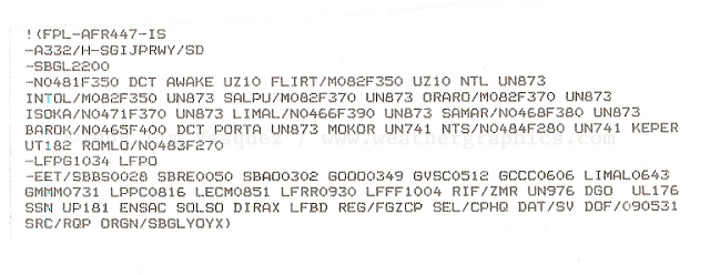
Tue, 2 Jun 2009 22:31:54 +0000
Your very professional and thorough weather analysis related to flight AF447 is what is all about I'm afraid. I am an A340 First Officer and my airline suffered a serious incident a couple years ago in similar circumstances when encountering severe icing and turbulence at high altitude which led to the sudden loss of all ADIRUs (Air Data/Inertial Reference Units) and to a reconfiguration to alternate fly by wire control law as a result, forcing the crew to declare an inflight emergency and land to the nearest suitable airport. Then it is not difficult for me to make a parrallel with flight AF447's last ACARS transmissions:
- 0210: Auto Pilot disconnects
- 0211,12,13: series of ADIRU and ISIS messages
- 0213: SEC1 FAULT, PRIM1 FAULT (Alternate Law) with lots of ATA34 (Navigation Systems), ATA22 (Auto Flight), and ATA27 (Flight Controls) messages, and increase of cabin vertical speed.
Best regards,
Alexandre B---
Tue, 2 Jun 2009 14:51:23 EDT
Hey Tim, I'm a UAL Airbus pilot and studying meteorology (using your Weather Maps and Forecasting books). What do you think of the possibility of a contributing factor being a positive lightning strike. From what I've read aircraft are not protected from positive strikes only negative. I read that positive chrges accumulate near the top of a convective cloud.
Thanks for your detailed analysis.
Mike A----
REPLY: Lightning polarity issues are kind of out of my league. Positive strikes can and do carry more current on average,
and they can occur in any storm with cold tops such as this one, but there's no way to know right now.
Tue, 02 Jun 2009 12:07:00 -0700
Tim,
Excellent information and analysis! There is no better to be found,
anywhere, I am certain.
Items that come to mind for me:
- Maximum altitude for an A330 is 12,300M -or- 40,354' (FL403)
- Lift/physics and aircraft performance is severely affected as the
altitude increases in smaller fractions/increments of altitude over FL300
- Flight crews often attempt to "fly over" cells/turbulence if
possible, when
severe conditions extend for periods that force a need to calm
passengers
- Navigation systems (and mission critical systems) have electrical
shunt to ground in case of increased electrical activity of an external
or internal nature (factors such as lightening strikes or ground power [AGE])
- A330 aircraft have RAT (ram air turbines) for backup electrical,
primarily due to the "fly by wire" profile/technology
- Debris field (post accident) is spread over 35 or so miles (latest
reports)
I wonder if the crew attempted to fly over the weather? My first three
points then
cause me to wonder if failure was inevitable.
I know that you had some question regarding the likelihood of the damage
any
lightening strike could have on systems. Flight computers and steering
command systems are internal and derive their data from external
sources.
Radar systems are external, and provide input to internal systems.
Failure from
a lightening strike has a higher probability in regards to a radar
system than it
does in regards to a navigation computer, due to their proximity to the
external
source of electricity. While the crew may have lost radar, it is
reasonable to
assume that the nav systems were most likely still available after a
reboot. The
radar being out would affect their ability to continue to "see" what was
ahead,
yet they most likely could still move in the same general direction
(navigate). It
is safe to assume that the shunt to ground of electricity would diminish
but not
eliminate their progress.
The debris field causes me great distress. To have debris in any body of
water, it
tends to stay close (say less than one mile). This debris field has been
reported
to be over 35 miles (see link provided). My curiousness has kicked into
major
overdrive here - something happened in flight and not at water level. I
am not an
alarmist, just the facts cause me to conclude this happened at a very
high flight
level - not at sea level.
Thanks again for your analysis, and time taken to share this with all of
us.
Steve G----
Tue, 02 Jun 2009 12:10:03 -0700
Tim, this is the most educated and advanced analysis that I've seen since this terrible accident occurred. As a Commercial Pilot for a major US Airline for over 15 years and now operating in Asia and the Middle East on Airbus Aircraft's, I find your theory, organization and knowledge and overall approach above all!
I hope that we can find the cause of this disaster soon, and most of all, to learn from it so it could be prevented in the future.
Great job and have a great day,
J J---- - Ex USAirways - Now, Hainan Airlines
Tue, 2 Jun 2009 14:11:46 -0500
Hi there. I'm married to a meteorologist who works for Lockheed's Flight Service group, working on my multi-engine IFR rating, and working on an advanced degree in atmospheric chemistry. I wanted to just shoot you a note recommending that you submit this to the AMS Journal and a few flight magazines for peer review- your analysis is excellent, and reads well for both laypeople and for academics.
My own curiosities about hail contributing to the crash were largely laid to rest by your analysis (that's why I'm a chemist and you're a meteorologist!), and I look forward to having other flight service specialists read your article.
Thanks much!
Thomas I----
Fort Worth, TX
Tue, 2 Jun 2009 15:22:20 -0400 (EDT)
FAR 25.341 which governs the (U.S.) certification of commercial airliners specifies gust encounters per the following:
(5) (i) At the airplane design speed VC: Positive and negative gusts with reference gust velocities of 56.0 ft/sec EAS must be considered at sea level. The reference gust velocity may be reduced linearly from 56.0 ft/sec EAS at sea level to 44.0 ft/sec EAS at 15000 feet. The reference gust velocity may be further reduced linearly from 44.0 ft/sec EAS at 15000 feet to 26.0 ft/sec EAS at 50000 feet.
While I have not checked, EASA (the European regulatory agency) probably has an identical requirement.
And though we do not know which gust condition is critical, whether a 44 fps gust at 15,000 ft or at the knee in the 20,000 to 30,000 ft range where the airplane's redline shifts from a knot limit to a Mach limit and the dynamic pressure is the greatest or at the maximum cruise altitude, the maximum tested vertical gust is 44 fps or less.
In practice, the airframe would be tested to loads 50% higher than the maximum expected. To take a SWAG, the energy level in a 54 fps gust would be roughly 150% of a 44 fps gust.
And reading from your weather analysis of AF447, the flight very well may have encountered a gust exceding 54 fps (37 mph).
Stan B--------
Tue, 02 Jun 2009 13:22:37 -0600
Excellent treatment of 447 weather issues. Thanks for taking the time to publish it. I'm neither a meteorologist nor an aviator, just intrigued by the science of both.
Questions:
Do you have anything to offer regarding the effect of both wind and tide on the debris location? If the aircraft either lost power or broke up at altitude, at the time of the 0214Z ACARS report, and was thereafter substantially in freefall, how far and in what direction might winds have pushed it before impact? Then, if you have any information on ocean currents at the time, how far and in what direction might debris have drifted--from impact until the possible debris sighting, about 1300Z on Tuesday?
--
Appreciatively,
The Muser
REPLY: I haven't yet looked into the debris field aspect. I think that would depend on very accurate coordinates
and I'm not sure this has been forthcoming from the media. Also there are too many unknown variables in regard
to heading during the descent (esp. if the flight was out of control), winds, and so forth.
Tue, 2 Jun 2009 15:28:16 -0400
Tim,
My compliments to you for a very professional description and summation.
I'm a retired (19 years) metallurgical engineer who specialized as a
materials failure analyst on jet engines.
Any such incident still grabs my attention. .
I appreciate your no nonsense approach and technical explanation of this
tragic event.
Regards,
Howard H----
Tue, 02 Jun 2009 22:42:40 +0300
Hey!
First of all, thanks for in-depth analysis and material of AFR477
tragedy.
http://www.weathergraphics.com/tim/af447/
I have meteorologist background and also lots of flying experience as
a passanger. Severe weather and aviation turbulence are special
interests.
First, in tropics, although thunderstorms normally reach very high
(15-19 km), the updrafts tend to be moderate or light compared to
mid-latitudes. Studies made on powerful hurricanes only showed some
10-15 m/s updrafts in the eyewalls. In short periods there can be
isolated stronger updrafts, but I guess they would also be below 30
m/s. Of course one might not only focus on updrafts. Downdrafts of
same amplitude nearby the updraft may also play a role.
Also, the reflectivity values (dBZ) are rather modest compared to
mid-latitudes. Above 50-55 dBZ values are quite rare even in a heavy
rain areas, indicating not so strong updrafts and slim chance of hail.
Lightning and water load, on the other hand, can be impressive.
Second, is about hail. I agree that anvil areas may contain small
graupel particles, but they are not usually dense enough to be even
felt in any way. Hail is very rare in tropics (sea level) and quite
rare in tropical thunderstorms (modest updrafts, very high water
content + warm air mass).
Third, severe turbulence. Tropical thunderstorms of this hight
(+50kft) are turbulence producers. I was wondering if some sort
gravity waves may have played some role here. Strong thunderstorms are
known to send these pockets of very turbulent air around them (CAT or
Clear Air Turbulence). If the airplane passed the new cell 10-20 km
distance, it may still have felt the turbulence waves. CAT is much
studied in the US and found to be the most common with visinity of
deep moist convection.
Fourth, the soundings. The Noronha soundings reach for humidity point
of view only to 11 km. Natal Aeroporto sounding (a bit further south
on mainland Brazil, but the closest from the coast) shows three layers
of dry air. Air is dry between 10.5-12 km. Winds are really weak
through out the sounding, but change direction eratically between 8
and 10 km. It is a bit hard to think how the dry air and sinking
motion behave in the big picture.
The picture I have in mind is that the plane has entered vast area of
cirrus clouds some time after leaving continental Brazil behind, and
the cloud layer has grown thicker and thicker. On some stage on-going
MOD turbulence has started. Not sure if pilots been able to see
visually flashes of in-cloud lightning (due to thick cirrus), but sure
plane's radar should have told them where the 'hot spots' are each
minute. Maybe the flight route got too rough for turbulence and the
pilots tried to manuver the plane away from hot spots, making it only
worse. We just don't know if the severe jolts of turbulence came with
total suprise or little by little, and if the cockpit was in full
force at the time (night flight, rest periods).
I wont go further on these speculations. These kind of cites gives
additional help and widens the view of perspective. Well done!
Best regards, JT
Tue, 02 Jun 2009 20:56:34 +0100
Tim
Fantastic analisys you performed here. Let me just feed you a couple of thoughts.
I'm a A310 pilot, and flown UN873 at night dozens of times, and deviations up to 80 nautical miles off track have been frequent. With tha A310 I don´t fly through any well shaped GREEN radar return at that altitude and in that area. Cb's are too tall in that area, and FL350 is well within the unacceptably active altitude, and will produce EXTREME turbulence (not severe), something aircraft structure can't cope with. The images you posted show an isolated cell right on UN873, between INTOL and the MCS, one that would probably favour a deviation of at least 25nm left of track. This deviation would put the aircraft facing the worse MCS zone, and would require further deviation.
The thing that puzzles me is that such deviations would require ATC coordination, and even if unable to contact the control, pilots will broadcast their deviation on interpilot 123.45 frequency. How come in a fairly busy area as that one at that hour, no one heard about AF447 deviating, nor ATC, nor other pilots? This is very strange, you don't fly trough such a storm.
Additionaly, concerning engine flameout, there have been several incidents involving B767's equiped with CF6-80 engines, caused by ice crystal buildups in the compressor stator vanes. Procedures instruct pilots that engine anti-ice is not required when SAT goes below -40ºC, but this incidents are rising the suspition that procedures may be wrong. These incidents have ended with succesful engine restarts when out of clouds.
Cheers
Manuel
Tue, 02 Jun 2009 16:00:53 -0500
Excellent write-up Tim! FYI, I also have some additional
satellite imagery and products posted on our CIMSS
Satellite Blog:
http://cimss.ssec.wisc.edu/goes/blog/archives/2601
-Scott
REPLY: Thanks Scott, and of course the analysis wouldn't have been possible without University of Wisconsin's
McIDAS software.
Tue, 2 Jun 2009 15:02:04 -0700 (GMT-07:00)
Tim,
Thank you for your thorough analysis. Very informative.
I am a scientist with a question to some of the pilots responding to your post. I usually listen to the cockpit communication channel on commercial flights, when available. Typically, when a plane hits turbulence, you hear the pilots communicating with other pilots, inquiring about whether at their altitudes and locations. I wonder how come there where no reports from other flights within radio range (what is that range?) of that nature. Any idea what the nearest flights at the time of crash were, and what were they seeing / feeling / hearing?
Many thanks,
Sharon
REPLY: There were probably only a couple of planes scattered over a vast area, probably crossing
through a weaker part of the storm and having nothing noteworthy to pass along. On the HF frequencies it can be
extremely hard to talk to one another. I was on a C-5 in Africa in July 1994, for example, and we were trying to give our
diplomatic clearance number to Cairo over HF radio. It was a nightmare due to static and bad reception, and by the time
we got our approval we were already 50 miles into Egyptian airspace. The pilot reports are a great thing over busy
airspace like the US where there is informality, but it's a different animal over the oceans.
Tue, 2 Jun 2009 19:02:03 -0300
Hi, Tim,thank you for your thorough analysis. One of the things that scare people most is not knowing exactly what happened and your report certainly helps clarifying it.
I came across a piece of news and am trying to make what it says meet with your report.
Apparently, there's a program by WMO (World Meteorological Organisation), called Aircraft Meteorological Data Relay Programme (AMDAR).
The data supports weather forecasting, climate predictions, and early warning systems ahead of natural disasters.
(more on that in this link from Reuters: http://www.reuters.com/article/latestCrisis/idUSL21026278)
Lufthansa jets subscribe to that, Air France doesn't.
Would this kind of information, available to the pilots of the Air France jet, have helped prevent the meeting of the airplane with the worst part of the thunderstorms it faced?
Julianna E---
REPLY: AMDAR/ACARS has only limited participation from a small handful of airlines, and it's all just automated wind and temperature
data. This can help improve forecast models somewhat, but it's not really of use for avoidance and real-time safety.
Sure would be nice if the airlines lifted the restrictions on the data, though. If you Gooogle around for it (see fsl.noaa.gov) you can see
they're very protective of it.
Tue, 2 Jun 2009 14:58:27 -0700
Sir: your informed article did not mention why a skilled crew, observing heavy precip. on the radar and a 200 mile lightning storm front would not take a 10degree deviation in heading and simply make up the time. I speculate that there might have been some hubris involved. JM
John M----
REPLY: It's speculation and I'll leave that to other forums that are focused on the flight deck.
In short flight operations in and around these systems are very
common, and in some route sectors in the tropics the systems are so large that there's just no way to avoid them.
Tue, 2 Jun 2009 14:36:14 -0700 (PDT)
I have just read Tim Vasquez's analysis of the flight of Air France 447. Maybe this is a stupid question, but why would a pilot ever fly into such a weather system? It sounds as though the ill-fasted Air France jet was one of at least several planes to go through what the media have described as a wall of violent tropical thunderstorms. Surely all pilots were aware of these storm masses. I thought SOP was to fly around such systems - in fact, it is incomprehensible to me that any pilot would play roulette by trying to plow through one.
Thank you for any light you can shed on this.
Best regards,
Nancy Lewis
REPLY: Flight ops through storms occur all the time with incidents being very rare, but they will always try to divert around cells using the airborne radar.
I would recommend checking out the airliners.net forum for the airline operations perspective.
From my own analysis this wasn't really a violent wall of storms, just a large active cluster typical for the tropics.
Tue, 2 Jun 2009 23:42:08 +0200
Well done, sir!
Phil
Tue, 2 Jun 2009 14:38:51 -0700
Hey Tim
About two years ago I remember seeing an email photo of a heavily loaded A330 wing in flight that a dead-heading pilot took. The picture showed large compression wrinkles on the upper skin just outside of the engine pylon. The discussion was that this condition on the stressed skin weakened the wing strength and an it was suggested that a engineering review of the G limit loading be conducted. Never heard any more on the subject.
Have you or anyone out there seen this email making the rounds or it could have been bogus.
Carl D----
37 yrs. w/US Carrier
Tue, 02 Jun 2009 16:14:41 -0500
Most (but not all) airliners that transit the ocean are now using CPDLC which essentially allows the airplane to pulse out position reports every so often regardless of the passage of a specific navigation fix. By doing so, the ATC computer can create what amounts to a radar blip on a screen where no radar really exists. If you were to go to Flightaware.com and input a FedEx flight from Memphis to Honolulu you would, in years past, see the track disappear off the map shortly after it passed beyond the Calif. coast. Now you can see the track all the way across the Pacific. The ATC controlling that segment of oceanic airspace would have to have compatible equipment. Many do these days. I don't know if that is available off the coast of Brazil but I feel certain most or all of the Air France long haul fleet are CPDLC capable. By the way, with CPDLC, there is no voice comm with ATC .. VHF or HF ... none. Once "feet wet", all comm is via the CPDLC system which means the two parties type messages to each other using a specific CPDLC protocol.
John W---- (retired cargo airline pilot)
Tue, 2 Jun 2009 09:30:48 -0700
Tim-
Thank you for your careful considered analysis of the weather in the vicinity of the loss of Air France. Having flown NY to/from the major cities of Brazil & Argentina I found your analysis fascinating. We were always crossing the ITZ in the dark trying to use the radar and lightning flashes to pick our way around and find crossing points in the seemingly ever present storms. I found your work fascinating and reinforced my position to go around the storms and pick a place to cross that is weakest. The airplane is no match for the destructive forces that can be found in and around thunderstorms. I once flew several hundred miles along a thunderstorm area until I found a place to cross. We were late arriving but we did arrive. My initial take is that these poor guys got caught in some weather the airplane could not handle and the airplane broke up in flight, probably through a series of events. I would hope that airlines put this analysis to use training those who must cross the ITZ every day. Well done.
Cheers,
Dennis L.
777-767 Captain ?retired.
Tue, 2 Jun 2009 09:47:52 -0700 (PDT)
Dear Tim:
Thank you for your meticulous endeavor to bring all the fact to such a real forum for all of us. I have be an Avionic/A&P Commercial Airline Mechanic for 20 years. I have in depth experience on both Airbus and Boeing. I have grown extremely fond of the Airbus because of it computerized nature. My personal experience has been with multiple airframe vibration, computer soft wear updated beyond belief. We have experienced many wiring problems with harness to short everywhere on the aircraft. This is all to save weight. There is no working wire what so ever. We have had lighting strikes that have put our aircraft down because of softball size dents and goofball size holes burnt right through the airframe. Sense there is so much composite on the aircraft for weight purposes we have some communication problems with the static dischargers. Most of all, the fly by wire, all the relays which..... if one little relay encounters a problem it can cause multiple issues. I have changed more hyd elec pump for failure and
ptu's than I can say. The elac,sec,and facs have there share along with the sfcc burning out. The issue of the aircraft going into alternate law and so on. A typical AM departure may be a power transfer problem ( AIRBUS) GAPCU lock out the power unit. A SEC fail. or SFCC wing tip brake lock out. no ACARS or ATSU. Power down rebot or remove power and start APU. I truly love the Airbus because of it's continues to amaze me. But a dark cockpit or 10 messages on ECAM. I do love this plane but in the Maintenance World it is call a throw away aircraft because of its life expectancy in comparison. I truly can only imagine what the crew would have been up against with such an abrupt end in communications. Thanks again for all your painstaking information you are a guru.
ACMX
Tue, 2 Jun 2009 13:03:10 -0400
Hi Tim
I am also a former AWS weather officer and I found your analysis quite interesting and very through. I've had a great deal of forecasting enroute weather for Tank Task force missions for 135's, 141's etc and I've been thinking for several days now about a hailstone hypothesis based on several experiences of hail at flight levels of 30, 000 feet over the mid-west US associated with super cells.
You're correct about hail normally staying in the low 20-25,000 AGL regime however, with super cell physics, the entire thermal environment shifts upwards with heating and strong convection. And the high reflectivity of hail may not register on the aircraft radar if the radar energy is heavily attenuated by high concentrations of precipable water in between the sensor and the hail field.
So my failure mode theory is hailstones colliding with the cockpit windscreen result in a hull or cockpit breach, followed by rapid depressurization and possible incapacitation of the flight crew thus preventing any emergency actions. The plane continues on for a very short time on A/P as water and possibly hailstone incursion soak/pulverize the interior cockpit electrical system, triggering the automated maintenance enunciators before the A/P goes off line with loss of all AC and DC electrical power.
I certainly don't like to speculate on such a horrible event but you may want to reconsider the potential of catastrophic hailstone damage associated with an unusually strong MCS traversal. The failure mode certainly fits the evidence although I don't have any factual evidence to prove/disprove the presence of hail at their FL. Bu t experience has taught me that sometimes we fail to appreciate the extremes in weather because we tend to study or observe average behavior (case in point, rogue waves). The largest hailstone on record is around 7 inches in diameter and came from a mid-latitude thunderstorm over Nebraska. Who knows what the ITCZ is capable of producing.
Again, nice analysis
Dick C-----
Senior Scientist
H---- Corporation
Tue, 2 Jun 2009 13:49:29 -0700 (PDT)
Dear Tim,
I'm an aviation enthusiast and a frequent flyer, 18 month ago I flew AF447 and since I asked to the captain to fill a logbook for me, Iâve the routing for my flight.
I copy: âNatal â Sal Amilcar â Canaria â Zamora â Nantesâ
I hope it can helps, unfortunately the season was very different (november) but was still an A330.
Congratulation for your analysis, really appreciated.
Regards,
Francesco P----
Genova - Italy
Tue, 2 Jun 2009 14:51:44 -0600
Tim,
I was a Delta B-767-400 Captain for many years flying the Pacific routes. While I believe weather WAS a factor, I think a more likely scenario is one similar to the AA 587 crash after takeoff from JFK in 2001.
Wake Turbulence caused the pilot to (allegedly- I have my doubts) push the rudder so hard that it separated from the fuselage. I think Airbus may have a design problem.
If turbulence for AF 447 was great enough, another structural failure may have occurred, causing the electronic malfunction signals to be sent to AF maintenance AFTER THE FACT- much like the signals that were sent to Mission Control as the Space Shuttle broke apart.
My best guess:
Turbulence resulting in structural failure or terrorism.
Thanks,
Captain Bill R---- (ret)
Tue, 2 Jun 2009 23:48:28 +0300
Hi Tim, thanks for an excellent analysis. I'm a First Officer with Gulf Air, flying the A330. Previously, I flew in West Africa for ten years which taught me a healthy respect for the ITCZ. Prior to reading your website, I had looked at the satellite images on the NASA website and the Met Office U.k, and your analysis confirms my fears. I'm disappointed that a flight could have been planned and dispatched through such dreadful weather. I'm not sure what factors came into play to lead to such a fatal decision.
Regards,
Richard Lambo
Tue, 2 Jun 2009 16:57:13 -0300
Congretulations Tim !
This analysis is one of the most professional that I ever had come across, when it comes to WX induced hazards for aviation. I am flying for more than 40 years now and the main lesson I draw from those years: ONE WILL NEVER STOP LEARNING. I would have to see my logbook to know how many times I crossed the ITC flying to/from Brazil, always considered it relatively less violent compared with e.g. a grown up monsoon squall line.......Your analysis is kinda readjusting my mindset.........
Keep on doing good work.
My best regards
Ernst S-----
Tue, 2 Jun 2009 16:44:59 -0400
Steven C wrote: "I think one key issue is whether the in flight conditions
across the ITCZ is unusual or is it common practice pilots to fly through
such weather conditions."
Having spent many years flying from the West Coast to Australia, I can
safely tell you that massive thunderstorms in the ITCZ are quite common.
Going from 10N to 5N was always an adventure, and often not a pleasant one.
The massive line of storms from west to east as shown on your image is not
unusual in the Pacific. You always pass through in the middle of the
night, so your greatest hope is a full moon that hasn't set yet. You have
radar, but sometimes all you see is the entire top of the screen in yellow
and magenta. Dispatch has access to satellite images, and sometimes that
helps when you are trying to decide in which direction to deviate.
But sometimes the lines of storms are so extensive that you can't go around
them because of fuel, or ATC has concerns about you flying into the
opposite direction track. Then all you can do is seat the Flight
Attendants, turn on the continous ignition, pucker up, and pick through the
line as best you can. Keep in mind that as soon as you enter the area
you're in the clouds and visually blind. You can never climb above the big
storms, but being higher helps clear some of the weather (but gives you
less of a performance margin).
One other thing to remember is the "dry thunderstorms" in the ITCZ.
There's a lot of violent storms in that area that don't have enough
moisture in them to show up on radar. There is a "turbulence mode" on your
radar that picks up the doppler wind shifts, but you have to be in the
lowest distance settings for it to work.
Kenneth ----
Tue, 2 Jun 2009 15:31:58 -0400
I've read your very accurate analysis on http://www.weathergraphics.com/tim/af447/ , by far the most interesting and scientific one available on
the internet. I?m am sometimes Flying small airplanes and I had a chance to do some research studies on weather and climate changes before my
PhD in Applied Mathematics & I am very impressed with this quick & sharp analyzis around this unexpected event chaining. Even if I am a
scientist, working mostly in the computer domain and aerospace sector, I wish this could only been theorical and we can find survivors
so that a miracle can happen.
Hervé A., France
Tue, 2 Jun 2009 12:48:18 -0700
Tim,
I just read your breakdown of the AIr France 447 tragedy. Very well
done. I fly an Airbus 320 (UAL), although smaller than the mishap
aircraft, similar in design--so I stay informed on issues that may
affect my aircraft.
I also flew C-141's out of KTCM from '89 through '02 and wanted to say
how much respect I have for AF forecasters and meteorologists like
yourself. I always had very valuable and useful information to go fly
with , and in very remote parts of the world. I really miss that level
of professional service now!
Thank you for your service and keeping us well informed!
Chip -----
Tue, 2 Jun 2009 20:02:07 -0000
If the lightning knocked out the radar for a while, they were flying blind and could have plowed into some really fierce cells. The Southern flight that went down flying to Atlanta years ago was a situation where the radar what shadowed by an extremely strong cell making the pilots believe the weather was a thin line. The normal practice is to tilt the radar down to show ground return behind the storm in order to detect a radar shadow, but over the water, this doesn?t work.
Byron A----
Tue, 2 Jun 2009 15:12:12 -0500
I found the evaluation of AF447 weather very interesting. Thanks!
I looked at your web site and see you were at Chanute AFB. You may or may not know Chanute is now closed. I Live in Rantoul and have a business located on the former base.
Best regards
Chris -----
Tue, 2 Jun 2009 15:24:30 +0200 (CEST)
G day Tim
I am an Air France Captain, found your post very interesting and if true, will be hugely damaging for Air France.
Best regards
B-----
Tue, 2 Jun 2009 08:32:11 -0400
I came across your analysis of the Air France accident, I just wanted
to say thanks for a thoughtful, fair, and well-reasoned theory of the
possible accident sequence. I also learned a bit about thunderstorms
in the ITCZ. Thanks again.
Jim E----
Captain B-737, Newark, NJ
Tue, 2 Jun 2009 08:21:23 -0400
Hi, Tim. I found your page after looking for more analysis on the Flight 447 disappearance. I want to thank you for your weather analysis related to the flight. It is by far the best resource I've found on the web.
Cheers,
Ken M-----
Tue, 2 Jun 2009 09:47:52 -0700 (PDT)
Thank you for your meticulous endeavor to bring all the fact to such a real forum for all of us. I have be an Avionic/A&P Commercial Airline Mechanic for 20 years. I have in depth experience on both Airbus and Boeing. I have grown extremely fond of the Airbus because of it computerized nature. My personal experience has been with multiple airframe vibration, computer soft wear updated beyond belief. We have experienced many wiring problems with harness to short everywhere on the aircraft. This is all to save weight. There is no working wire what so ever. We have had lighting strikes that have put our aircraft down because of softball size dents and goofball size holes burnt right through the airframe. Sense there is so much composite on the aircraft for weight purposes we have some communication problems with the static dischargers. Most of all, the fly by wire, all the relays which..... if one little relay encounters a problem it can cause multiple issues. I have changed more hyd elec pump for failure
and ptu's than I can say. The elac,sec,and facs have there share along with the sfcc burning out. The issue of the aircraft going into alternate law and so on. A typical AM departure may be a power transfer problem ( AIRBUS) GAPCU lock out the power unit. A SEC fail. or SFCC wing tip brake lock out. no ACARS or ATSU. Power down rebot or remove power and start APU. I truly love the Airbus because of it's continues to amaze me. But a dark cockpit or 10 messages on ECAM. I do love this plane but in the Maintenance World it is call a throw away aircraft because of its life expectancy in comparison. I truly can only imagine what the crew would have been up against with such an abrupt end in communications. Thanks again for all your painstaking information you are a guru.
ACMX
Tue, 2 Jun 2009 12:39:37 +0200
hi Tim,
I just read the analysis you made here...
http://www.weathergraphics.com/tim/af447
Thank you for the insight and excellent documentation.
Best regards
Oscar Stefan M----
Copenhagen - Denmark
Tue, 2 Jun 2009 12:36:53 +0200
Tim, what a super professional meteorological analyzis of the AF447 crash.
I'd fly with you anytime.
I wish the pilots had had the info you have gathered.
RIP for all crew and passengers of AF447.
Kelly
Tue, 2 Jun 2009 10:42:32 +0200
Hi Tim!
I live in Sweden and I have worked as a pilot since forever it feels like. I´ve flown into, over and around tropical storms (but I NEVER get used to the BANG of a lightning strike...) and I am impressed about your analysis of the Air France 447 situation. Being 48 yo I am SO tired of rumors and bs and I really get a kick out of analysis, knowledge and research. I work as an instructor as well as for the Swedish CAA with pilot examinations and it is really a lot of fun spreading knowledge. Life gets so much easier when it´s based on fact.
Keep up the good work!
Lars N-----
Tue, 2 Jun 2009 09:49:17 -0400
Hello Tim,
I find your explanation of the meteorology for the Air France flight extremely interesting. I have a few questions though:
- how come updrafts are materialized by cold air? Since this is air coming from below, it should be warmer than its surrounding or am I wrong?
- at one point you speak about "CAPE" Since I am an aerospace phd student and I am curious about it, what is CAPE? how is it expressed ? and how do you relate that to the vertical up-gusts?
- do you have any recommended good reading (textbooks) about these concepts?
I am very interested. Thanks for your great explanations so far !
My regards
Cedric
Tue, 2 Jun 2009 22:27:14 +0930
Top analysis: Thanks for doing it.
J
Tue, 02 Jun 2009 12:47:26 +0300
Hello Tim,
On your page of meteorological analysis of the recently lost flight you
weren't quite sure what lightning would do to an aircraft. If you're
interested, here's a study by the FAA of the effects of lightning
strikes on planes: http://www.tc.faa.gov/its/worldpac/techrpt/ar04-13.pdf
Regards,
Sami Y------
Tue, 2 Jun 2009 09:47:02 +0200
HI Tim,
As an air traffic controller myself, I was very interested in your
meteorological analysis of AF447's possible cause of disappearance.
One small note, on the related flightplan you mention. VRG = Varig
Linhas Aereas, not Virgin Atlantic (which is VIR)...
Thanks for the interesting info.
Cheers,
Steven
Tue, 2 Jun 2009 16:45:49 +1000
I think its SOP with many airlines and airliners, to turn on the engine ignition system when approaching heavy precip ? the exact term for the procedure escapes me, its 20 years since I was an air traffic controller.
Whether or not its Airbus or Air France SOP to do so is not known to me.
Excellent analysis btw ? all I can say is I hope your wrong and all are found safe&
Leif E----- | Support Analyst
Adelaide
Tue, 2 Jun 2009 11:57:52 +0100
Just a short note of thanks for your detailed analyis of the
conditions encountered by AF447. I am a pilot and an amatuer
meteorologist and have bought all your books, and this was just the
type of information I was looking for.
Well done
Fergal T-----
Ireland
Tue, 02 Jun 2009 00:41:56 -0400
Hello,
Your analysis is very interesting and very informative. It is a very
unfortunate incident.
I think one key issue is whether the in flight conditions across the
ITCZ is unusual or is it common practice pilots to fly through such
weather conditions. I am not
an expert to aviation, but I have flown through or near bad weather. So
it will be informative to know under what conditions pilots will go
around bad weather. A MCS
of that size can be probably spotted by the crew visually (via lighting
strike) or radar on the aircraft.
I actually look at what the TRMM website for data around that time. It
shows very impressive MCS around the general area of the flight around
03Z01JUN.
Best Regards,
Steven C----
Tue, 2 Jun 2009 14:00:50 +1000
Thank you for your explanation of the MCS system, that 100 mph vertical
rise would have been quite horrifying. Have been a pilot for 40 years
and have seen a few lines of TS in Papua New Guinea and Australia,
there is always one cell that is more violent than the last .
Thank You,
Bruce T-----
Mon, 01 Jun 2009 20:49:51 -0400
Found your website via Wikipedia entry on AF447.
An insightful analysis; thanks.
[BTW My bet is structural breakup in extreme turbulence, though I
sometimes wonder about lightning strikes on FBW control systems]
Good luck to you in all your endeavors.
chuck
Chuck E-------
Mon, 1 Jun 2009 19:56:44 -0400
Tim just read your analysis of the Air France Flight crash. Great job !!! Sad situation.
Anyway to speculate updraft strength? A 100 mph updraft or downdraft is a lot to overcome should that have been the problem. My thinking it was probably a combination of electrical failures and severe turbulence.
Jim -------
The Weather Channel
Mon, 1 Jun 2009 22:25:12 -0600
Tim,
I really liked your weather analysis of the thunderstorms along AF
447's route. I drive an Airbus for a new US carrier. I have a theory
based upon what I've read so far, but your analysis doesn't mention
the critical contributing factor I believe caused the crash...
Hail
Can you determine from your information if it was present and in what
degree?
Thanks for the interesting read.
Chad H-----
REPLY: Thanks. I'm open to the hail idea but I've never heard of large
hail in equatorial sectors, partly due to the degree of shear,
instability, and proximity of cold air to the updraft required
to sustain it, and I'm not seeing much in the way of patterns
on the soundings to support it. The plane would have been
far above the critical hail formation layer and I don't think
there was enough instability to form or loft any stones
up to FL350, though I could be wrong.
Maybe I haven't read enough reports from the tropics about
inflight hail occurrences to make a good assessment.
Chad writes on Mon, 1 Jun 2009 23:31:18 -0600:
That's what I was wondering about. A hail encounter at 350 would be
very rare. The highest I'm aware of, that actually resulted in an
accident over North America was AirTran 426 that encountered hail up
to FL205.
The reported loss of both the electrical system and pressurization
would almost certainly have to be a dual engine flameout. Though
lightning has been speculated, I don't buy it. A dual flameout would
however immediately result in a complete electrical and pressurization
failure. LIkely causes for a dual flameout could be rain/hail, icing,
or perhaps an upset.
If such an event occurred, the plane is equipped with a Ram Air
Turbine (RAT) which provides electrical power to essential busses as
well as hydraulic power to one of the three hydraulic systems. This
would give them enough power to effect a controlled descent and a
reasonably controlled ditching. However, if it was a hail encounter
of sufficient intensity to cause a flameout of both engines, the hail
would almost certainly damage or destroy the RAT's composite propeller
blades, rendering it useless and the plane uncontrollable.
Previous hail encounters sufficient to cause dual engine flameouts
occurred around 16,000 ft in the case of Southern Airways 282 and TACA
110. Given your analysis I'd almost begin to wonder about a
turbulence induced upset.
Thanks again for the info.
Chad
Mon, 1 Jun 2009 23:38:02 -0400
Tim,
I am an A320 Captain at US Airways. Your analysis is extremely compelling. I am curious as your take on this flight encountering hail. My other thought is whether this aircraft was flying at an econ cruise speed just above Vls, encountered an updraft that may have suddenly decreased the speed below alpha floor causing a stall. Although the Airbus has protections, during the dark, lightning flashing, turbulence, etc, the crew may have easily become disoriented if this was the case.
Thoughts?
Regards,
Steve B-----
Mon, 1 Jun 2009 22:20:38 -0400
I enjoyed reading your analysis of last night's weather and how it may
have impacted the AF flight. I am neither a pilot or a meteorologist,
just a physician that flies a lot and always interested in the clouds
outside the aircraft. Thank you.
Bruce C-----
Mon, 1 Jun 2009 18:21:59 -0700
dude, you rock!
i'm a commercial (UAL) international pilot -
nice job!
mark
Mon, 1 Jun 2009 20:42:53 -0800
Thank you for your indepth (impressive) analysis on the weather conditions present for flight 447. It gave me a far better understanding of the challenges they faced than has been shared in the media outlets.
http://www.weathergraphics.com/tim/af447/
Regards,
Gail G------
©2009 Tim Vasquez / All rights reserved
|
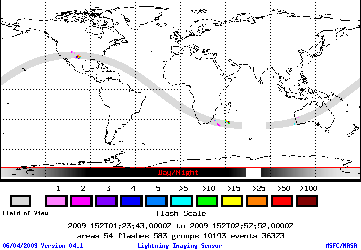
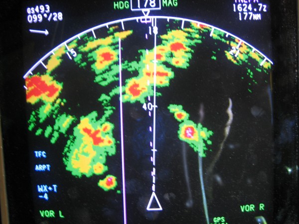
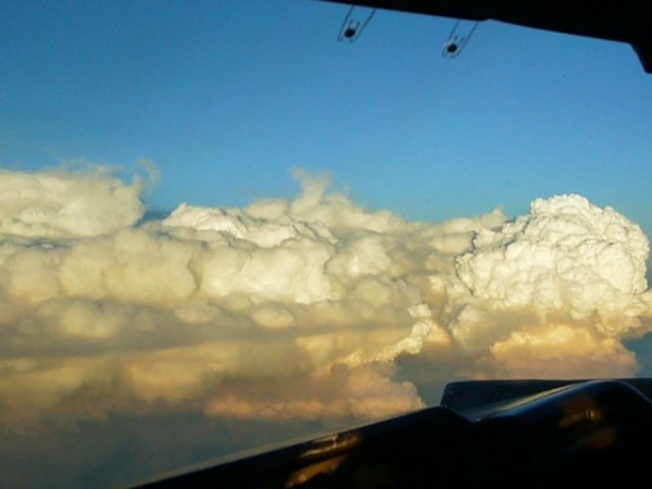